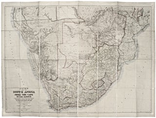
Myanmar (Burma)/ Thailand/ Bangladesh. FRIES, L., PTOLEMY, C. [Lyons: 1522/ 1535] [On verso:] Tabula XI Asiae. 11 x 16 inches. Fine hand color; excellent condition. One of the earliest acquirable maps to focus on a specific region of Southeast Asia. The areas depicted on the map is primarily today’s Myanmar.....
Results
Eur: IX Tab:.
The very scarce, first state of this attractive map engraved by Gerard Mercator himself of what is today northwest Turkey, including Istanbul (here Byzantium) and the Dardanelles. Also on the map are present-day northern Greece, Macedonia, Albania, Bulgaria, Romania, Kosovo and Serbia. Meeting in this map are two of the.....
Europ: III Tab:.
A scarce, early issue, the second overall, from Mercator’s definitive edition of Ptolemy’s geography. The map shows France as it was known in the Roman Imperial period. It was based on geographic data and mapmaking instructions left by Alexandrian astronomer and geographer, Claudius Ptolemy (fl. A.D. 127-180), whose work laid.....
Appendix. III. Tabulae Afr:.
An attractive example of the second issue from Mercator’s definitive edition of Ptolemy’s geography. The map shows the area as it was known in the Roman Imperial period and includes Alexandria, the homeland of it maker, Claudius Ptolemy, and the center of learning at the time. Also on the map.....
Novi Belgii Novaeque Angliae.
A map that is as historically important as it is attractive: it was the culmination of all the surveys conducted by the Dutch colonists of New Netherlands during their first three decades in America. It is also the first printed map to delineate the shape of Manhattan with relative accuracy;.....
Two sheets: America West Cape Mendocino to Vancouver Id. from Cape Flattery southward... [and] America West Diego Bay to Cape Mendocino.
Scarce, finely engraved chart on two sheets of the entire west coast of the United States and including the southern portion of Vancouver Island. Each of the 27 coastal recognitions on the charts is delicately realized. These provided visual reference for the entry to the major bays and ports as.....
Perrine's New Topographical War Map of the Southern States Taken from the latest government surveys and official reports. [With booklet:] A Concise History Of The War….
Large, detailed, up-to-date map of the entire theatre of the American Civil War, accompanied by a booklet that provides a day to day history of the war from its beginning to November 30th, 1863. Red circles on the map indicate the sites of engagements. Railroad lines are shown throughout, and.....
Out of stock
Caelestem Hic Terram Inspicias Terrestre Q[uam] Caelum.
One of the earliest and rarest printed world maps; the first to be published in northern Italy. The Berlinghieri is certainly the rarest of the early Ptolemiac world maps, aside from the unobtainable 1477 Bologna edition. It is also the only early Ptolemaic world map to employ the same projection.....
Europae II Tab:.
An early edition, the second, of Mercator’s definitive presentation of Ptolemy’s map of Spain and Portugal. In this map, engraved by Mercator himself, was the meeting of two of the most important figures in the history of geography. Geographic data and mapmaking instructions left by the Alexandrian, Claudius Ptolemy (fl.....
Norumbega Et Virginia.
This very early map reveals the state of geographic knowledge of the Northeast and Mid-Atlantic regions at the time of their initial colonization. "A superbly executed engraving, [the map] depicts the northeastern American coastline as it was perceived by European geographers one hundred years after the discovery of the New World.....
Novi Belgii Novaeque Angliae.
This is the most lavishly decorative of all the early editions of the best 17th century, Dutch map of the Northeast and New York. It added illustrations of animals and other detail not found on previous issues. The map was the culmination of all the surveys of the area conducted.....
Map of the Towns of Saybrook and Old Saybrook Middlesex County Connecticut.
A beautifully preserved wall map, in very attractive, period wash coloring, of the lower Connecticut towns of Old Saybrook, Essex, Deep River, Centerbrook and Ivoryton, located at or near the mouth of the Connecticut River on the eastern side. The overall map is complemented with plans of the central areas.....
State of California. Published by the Department of the Interior, General Land Office. J. A. Williamson, Commissioner.
Attractive, richly detailed map, important for the extent of railroad information that includes even small spur lines and stations. Also significant is the table listing 545 private land grants that are keyed to the map. Using the best available sources, the map was compiled from the official records of the.....
State of Nevada. Published by the Department of the Interior, General Land Office. J. A. Williamson, Commissioner.
An excellent map of the state compiled from the official records of the General Land Office and other sources by C. Roeser, Principal Draughtsman of the G.L.O. Mining operations and mountain ranges are shown in considerable details. It also shows rail lines, range and township lines, cities and towns, county.....
Gentlemen's Driving Map Showing The Park System Of Boston…First Edition.
A rare map (not appearing in map market records) made of the "Gentleman" bicyclist, highlighting the not particularly ample park areas of Boston at the time. Noted with cautionary red lines are roads with street car tracks, presumably to be avoided by cyclists. Slanted green lines indicate unfinished roads. Bicycling.....
Railway And Highway Map of the Famous Berkshire Hills Region, Showing Villages And Also Points Of Interest;….
Large, attractive map of the lovely highlands of Berkshire County, one of the premier cultural-recreational destinations in the United States. Issued as a promotional instrument for the Berkshire Life Insurance Co., the map dates from the early days of the area as a recreational area. The map notes the mountain.....
Juta’s Map of South Africa From The Cape To The Zambezi.
This large, superbly detailed map of South Africa shows the region just prior to the outbreak of the Second Boer War. The Boer territories - Orange Free State and the South African Republic - are both shown in yellow, as distinct from the surrounding red of British lands. The gold.....