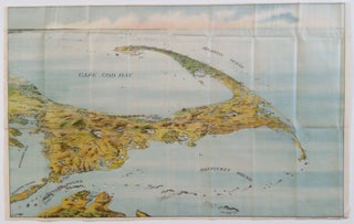
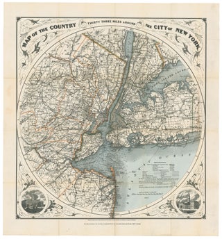
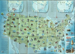
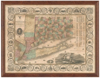
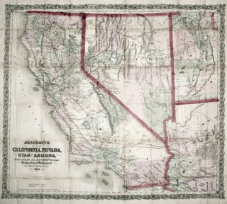
Results
Bancroft's Map of California, Nevada, Utah and Arizona,
A bright, vibrant example of a map of California and the western states by "the greatest map publisher of the Pacific Coast" (Wheat). The map descended from what Wheat called "the great 'map of the Pacific states'"--that of William H. Knight, published in 1863, also by the Bancroft firm. The.....
The First Hotel Erected by the Oak Bluffs Land & Wharf Co. 1867.
A superb chromolithograph, subtly capturing the burnishing effects of rosy dawn lighting, on Martha’s Vineyard first resort hotel. The plain, somewhat barn-like structure depicted here is in keeping with the middle-class nature of the Wesleyans who created the island’s first resort community. Other and grander hotels soon followed, resulting in.....
United States/ New York State/ Railroads/ Advertising. HANNIFAN & CO., Publisher/ RAND MCNALLY, Printer [New York, 1886] 1885.-Railroad Map And Business Guide in Book Form.-1886.Embracing the Principal Manufacturers, Trades and Representative Business House of Utica, Rome Camden..and Schenectady. 25 ½ x 39 ½ inches. Lithographed folding map with original hand.....
Provincetown, Massachusetts. Walker Lith. & Pub Co. ]Boston: 1910] Walker’s Bird’s_Eye View of Provincetown… 10 ½ x 16 ¾ inches. Two-stone, folding lithograph on banknote paper, in original heavy paper covers, with street plan on front cover. Light glue stain at left else an excellent example. In.....
Map Of The Balkan Peninsula….
A rare, clearly printed, political map of this volatile region, described as "entirely new" in the advertisement included here. Although the map is not dated, the Royal Geographic Society reported its acquisition of an example in July of 1914 (see below). Since the Archduke Franz Ferdinand was assassinated on June.....
Out of stock
A New Chart of the World On Mercator's Projection With The Track Of The Most Celebrated & Recent Navigators.
A beautiful example in full, vibrant, period color of a majestic, folding world map. A rare issue with very important updates. The map is an extraordinary compendium of oceanic exploration and contains voyage tracks from the 15th century to those contemporaneous with the map including those relating to polar and.....
The Cerographic Missionary Atlas… [Imprint inside front cover:] Entered according to Act of Congress, in the year 1848, By Se. E. Morse & Co.,….
An unusually well-preserved, scarce, and quite early American atlas of areas where missionary activity was being, or could be conducted. Includes an excellent map exclusively of the Hawaiian Islands. A map entitled “Indian Territory” encompasses Texas and east from Lake Superior and the Mississippi River to the Rocky Mountains in.....
Minneapolis, MINN.
Rare and in superb condition. The second printed view of the Minneapolis, which was preceded only by Hageboeck view of 1873 and a view of both St. Anthony and Minneapolis in 1867, the year of the latter city obtained its charter. This is the larger, separately-published version of the view.....
Washington Territory. J. K. GILL & CO./ GALVANI, W. H. [Portland, OR: 1884] J. K. Gill & Cos. Map of Washington. Portland Ogn. 1884./ New Sectional, Township & County Map of Washington…1884. 22 ½ x 27 inches. Lithograph with full, original wash color. Ex-folding map, here flattened, original embossed covers.....
Washington State/ Mining History. RAND, MCNALLY & CO. [Chicago: 1890] Rand, McNally & Co.’s Sectional Map Of Washington. Scale, Eight Miles to One Inch. The Map Includes The Coeur d’Alene Mining District In Idaho… 37 1/4 x 55 3/4 inches. Lithograph with original hand color. Ex-folding map that has been.....
Panoramic Views along the Line of the Denver & Rio Grande Railroad. The Scenic Line Of The World.
A superbly realized promotional brochure, one of the finest we've seen, issued by the Denver & Rio Grande Railroad, featuring a sequence of nine beautiful views of Colorado's mountainous natural wonders, many with trains cutting through the landscape. Fittingly the railroad's original motto was "Through the Rockies, not around them.".....
New England/ Business & Real Estate History. CALHOUN PRINT CO. (publisher) [Hartford, CT: n.d. c. 1900] BUY HOMES OF J.W. WILBUR CO. 26 ¼ x 39 inches. Color-printed wood engraving. A few edge splits, printer’s crease at upper left, overall excellent condition. A large, vibrant broadside, produced for the visionary.....
Elmer J. Chute’s Map of the Goldfield Mining District Nye and Esmeralda Counties, Nevada. 1905.
Rare, separately published map of the site of the last, great American gold rush. The map clearly plots out the claims of the many companies working the area with colors designating the largest of them. The great hopes for the area are expressed on the map in the route of.....
Cape Cod. MURPHY, John F./ FEDERAL ENG. & PUB. CO. [Boston: dated 1905] Untitled view/ map of Cape Cod. 17 x 26 ¾ inches. Colored lithograph. Folding view, flattened; without covers; very slight fold wear, else a fine example. A rare, sweeping, aerial view emphasizing Cape Cod’s striking hook-like shape.....