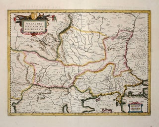
Serbia/ North Macedonia/ Bulgaria/ / Romania/ Bosnia/ Kosovo/ Albania/ Constantinople. MERCATOR, G. / HONDIUS, H./ JANSSON, J. [Amsterdam: 1636] 13 1/2 x 18 1/2 inches. Walachia, Servia, Bulgaria, Romania. Fine hand color; centerfold reinforced, else excellent condition. A detailed and attractive map of the lands surrounding the Lower Danube in the.....
Results
Colton’s Map of the Oil District of West Virginia and Ohio.
Very scarce, richly informative map showing the oil, gas and coal discoveries in West Virginia at the beginning of that region’s oil boom. The key areas along the Little Kanawha and Hughes Rivers in West Virginia and on Buck Creek in Ohio are shown in great detail. Roads, railroads and.....
Bancroft's Map of California, Nevada, Utah and Arizona,
A bright, vibrant example of a map of California and the western states by "the greatest map publisher of the Pacific Coast" (Wheat). The map descended from what Wheat called "the great 'map of the Pacific states'"--that of William H. Knight, published in 1863, also by the Bancroft firm. The.....
Out of stock
Occidentalis Americae partis, ve, earum Regionum quas Christophorus Columbus.
Arguably the most beautifully engraved early map of the Caribbean, including Florida and the Southeast, here with color of uncommon beauty. The map includes representations of Columbus’ ships and various notes regarding his discoveries. It appeared in Book IV of De Bry’s Grands Voyages with text by Benzoni. De Bry’s.....
Southeast/ Florida/ Columbia/ Bolivia ORTELIUS, A./ CHIAVES, H. [Antwerp/ London, 1584/ 1606] La Florida. Auctore Hieron. Chiasues. Peruviae Auriferae Regionis Typus… Guastecan Reg. 14 x 18 inches. Fine original color; light staining along centerfold & a bit in the margins, else excellent condition. .....
The North part of America . . .
North America/ California as an Island/ Northwest Passage. BRIGGS, H. [London, 1625] The North part of America . . . 11 3/8 x 14 inches. Excellent condition. .....
Carte Tres Curieuse de la Mer du Sud.
A splendid example, with rich, vibrant hand color, of a wall map of extraordinary intricacy and detail: "one of the most decorative maps of North America of the 18th century" (Tooley). Its elaborate illustrations provide a panorama of the Discovery Period, colorfully depicting the mores, rituals and practices of indigenous.....
Burritt's Sectional and Township Map of Minnesota Compiled from the latest authentic sources by J.B. Power, Chief Draughtsman Sur. Genl. Office, St. Paul, Minn. 1870. .
Scarce. A large, richly detailed map of the state of Minnesota, revealing the dramatic expansion of railway connections from the Great Lakes into the West. First printed in 1870, the map was quickly updated with this 1871 edition in order to keep up with the rapid changes taking place in.....
Minneapolis, MINN.
Rare and in superb condition. The second printed view of the Minneapolis, which was preceded only by Hageboeck view of 1873 and a view of both St. Anthony and Minneapolis in 1867, the year of the latter city obtained its charter. This is the larger, separately-published version of the view.....