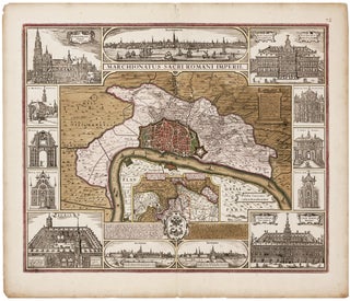
Antwerp/ Financial History. VISSCHER, C.J. /VISSCHER, N. J. [Amsterdam, c. 1630] Marchionatus Sacri Romani Imperii… C.J. Visscher Excudebat. 18 x 21 ¾ inches. Fine original color; bit of edge chipping & toning in margins, else excellent. .....
Antwerp/ Financial History. VISSCHER, C.J. /VISSCHER, N. J. [Amsterdam, c. 1630] Marchionatus Sacri Romani Imperii… C.J. Visscher Excudebat. 18 x 21 ¾ inches. Fine original color; bit of edge chipping & toning in margins, else excellent. .....
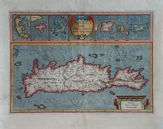
Crete/ Greek Islands. MERCATOR, G./ HONDIUS, J. [Amsterdam, 1633] Candia cum Insulis aliquot circa Graeciam. 13 ¼ x 18 ¾ inches. Fine hand color; lower margin, centerfold & cartouche at lower right reinforced, still very good overall. A very beautifully engraved and colored Dutch map from the great partnership of.....
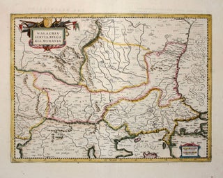
Serbia/ North Macedonia/ Bulgaria/ / Romania/ Bosnia/ Kosovo/ Albania/ Constantinople. MERCATOR, G. / HONDIUS, H./ JANSSON, J. [Amsterdam: 1636] 13 1/2 x 18 1/2 inches. Walachia, Servia, Bulgaria, Romania. Fine hand color; centerfold reinforced, else excellent condition. A detailed and attractive map of the lands surrounding the Lower Danube in the.....
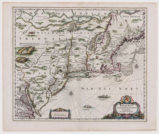
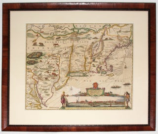
Northeast/ New York City. JANSSON, J. [Amsterdam, 1651] Belgii Novi, Angliae Novae, Et Partis Virginiae Novissima Delineatio. 17 ¼ x 20 ¼ inches. Superb original color; a few vertical creases else excellent with wide margins. .....
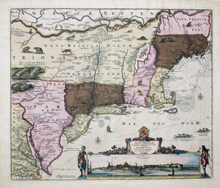
A map that is as historically important as it is attractive: it was the culmination of all the surveys conducted by the Dutch colonists of New Netherlands during their first three decades in America. It is also the first printed map to delineate the shape of Manhattan with relative accuracy;.....
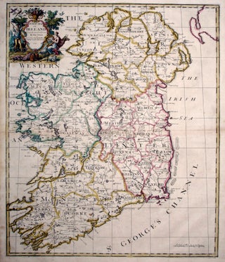
John Senex’s large folio map of Ireland, in a beautiful example with a bold strike and rich hand color. The map shows Ireland’s counties, cities and towns, waterways and loughs as expected, but includes more unusual information as well, such as the pilgrimage site of Saint Patrick’s Purgatory in County.....
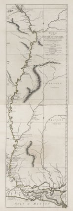
Tall, striking work based on the first official survey of the lower Mississippi River done in 1763. The map extends north to just below St. Louis. It provides considerable detail for the New Orleans area and shows Baton Rouge and Lake Pontchartrain. The map is significant for its delineation of.....
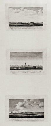
The complete set of six views (on two sheets), all relating to Boston; very rarely seen complete. These fine engravings of various vistas of Boston are important records of the area prior to as well as just after the beginning of the Revolution. Three of views show Boston itself, from.....
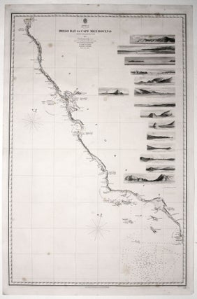
Scarce, finely engraved chart on two sheets of the entire west coast of the United States and including the southern portion of Vancouver Island. Each of the 27 coastal recognitions on the charts is delicately realized. These provided visual reference for the entry to the major bays and ports as.....
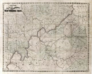
Very scarce, richly informative map showing the oil, gas and coal discoveries in West Virginia at the beginning of that region’s oil boom. The key areas along the Little Kanawha and Hughes Rivers in West Virginia and on Buck Creek in Ohio are shown in great detail. Roads, railroads and.....
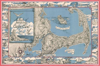
Cape Cod. MILLER, F. J. [Westwood, MA, c. 1945-1950] A Map of Interesting Cape Cod Plublished (sic) by F. J. Miller 1045 High Street Westwood, Mass. Copywright (sic) F. J. Miller Three-stone lithograph. 21 ¾ x 33 inches; with frame: 25 x 36 inches. Some fading of red border, else.....
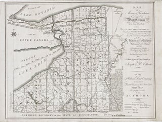
New York State/ Land Speculation. ELLICOTT, J. & B. [Philadelphia: 1801/ 1804] Map of Morris's Purchase or West Geneseo in the State of New York: Exhibiting Part of the Lakes Erie and Ontario, the Straights of Niagara, Chautauque Lake and All the Principal Waters ... Purchased by the Holland Land.....
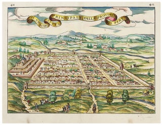
Cusco/ Peru. RAMUSIO, J. G./ GASTALDI, G. [Venice, 1556/ ?] Il Cuscho Citta Principale Della Provincia Del Peru 11 x 15 inches. Fine hand color; bit of creasing along vertical fold else fine condition .....
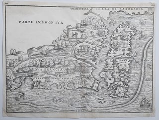
New England/ New York City. RAMUSIO, J. B./ GASTALDI, G. [Venice, 1556] La Nuova Francia. 10 1/2 x 14 1/2 inches. Woodcut map. A few minor marginal repairs, else excellent condition. .....
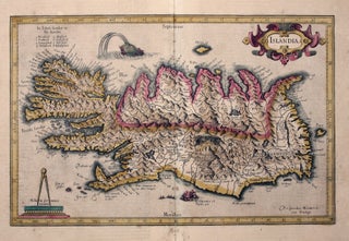
Iceland. MERCATOR, G./ HONDIUS, J. [Amsterdam, 1609] Islandia. 11 x 17 inches. Fine original color; lower centerfold reinforced, lightly toned, overall very good. .....
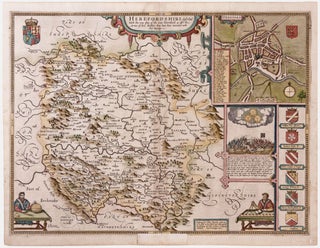
First edition and a fine example of this picturesque map evoking the rugged, forested terrain of the western English county with its many castles. At upper right is a plan of the town of Hereford with its great cathedral at the center, where is housed the legendary, medieval world map. .....
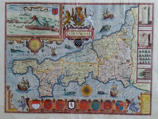
Cornwall/ England. SPEED, J./ John SUDBURY & G. HUMBLE [London, 1610 [1614?] Cornwall. 15 x 19 ¾ inches. Fine hand color; a few mended edge split, else excellent. First edition and finely colored example of Speed’s Cornwall, one of his most elaborately decorative maps. A plethora of ships, sea.....
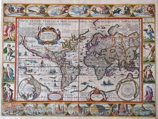
World/ Northwest Passage/ Australiana. KEERE, P. VAN DEN/ JANSSON, J. [Amsterdam, 1621/c. 1636] Totius Terrarum Orbis Geographica ac Hydrographica Tabula. 15 1/2 x 21 inches. Fine hand color; a few mended, inconspicuous into engraved surface & along a vertical crease, largely in margins, good overall. .....
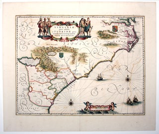
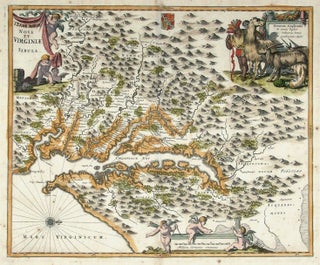
A map that combines elegant design with historical importance, it depicts the area from the lower Chesapeake Bay, down through North Carolina’s Outer Banks, the entire coastlines of South Carolina and Georgia, along through to northern Florida. The map reflects the growth of the English colony beyond the Jamestown settlement.....
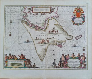
Patagonia/Tierra del Fuego. JANSSON, J. [Amsterdam: c. 1650] Tabula Magellanica Qua Tierrae del Fuego... 16 x 20 ¾ inches. Fine original color, fine condition. A stunning example, in full original color, of Dutch decorative cartography, this.....
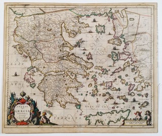
Greece/ Greek Islands. LAURENBERG, J./ JANSSON, J. [Amsterdam: 1650] Hessas. Seu Graecia Universa. Autore J. Laurenbergio. 18 ½ x 22 ¼ inches. Fine original color; lightly toned, a marginal split, else excellent. .....
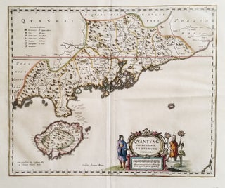
An exceptionally fresh example, in brilliant original color, of the earliest separate map of the area that now includes Hong Kong. Macau, Guangzhou (Canton), and several other place names appear in the Zhu (Pearl) River delta, and Hainan Island to the southwest is quite well detailed. Finely engraved Oriental figures.....
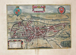
Scarce, large-paper, Jansson edition beautifully engraved, bird’s-eye view of the English cathedral city of Norwich that was also a center of the wool trade. With vibrant, full original color. From Jansson’s magnificent, eight-volume townbook atlas.
Virginia/ Maryland. OGILBY, J./ MONTANUS, A. [Amsterdam: 1671] [Terrae- Mariae] Nova [et] Virginiae Tabula. 11 3/8 x 13 7/8 inches. Fine hand color; old manuscript additions to title; lightly age-toned, else excellent condition. .....
This is the most lavishly decorative of all the early editions of the best 17th century, Dutch map of the Northeast and New York. It added illustrations of animals and other detail not found on previous issues. The map was the culmination of all the surveys of the area conducted.....