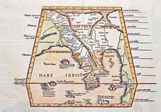
Myanmar (Burma)/ Thailand/ Bangladesh. FRIES, L., PTOLEMY, C. [Lyons: 1522/ 1535] [On verso:] Tabula XI Asiae. 11 x 16 inches. Fine hand color; excellent condition. One of the earliest acquirable maps to focus on a specific region of Southeast Asia. The areas depicted on the map is primarily today’s Myanmar.....
Results
Partie des Côtes de Labrado Depuis le Cap Charles a la Baye de Sandwich….
A mint example of this Revolutionary War-era chart, made for the use of the French Navy, and published the year before France became an ally of the American cause. It details the easternmost coastline of Labrador, and provides an inset chart of Mecklenburg Harbor. Georges-Louis Le Rouge (c. 1712-c. 1790).....
Bancroft's Map of California, Nevada, Utah and Arizona,
A bright, vibrant example of a map of California and the western states by "the greatest map publisher of the Pacific Coast" (Wheat). The map descended from what Wheat called "the great 'map of the Pacific states'"--that of William H. Knight, published in 1863, also by the Bancroft firm. The.....
Out of stock
Carte des Antilles Francoises et des Isles Voisines.
A very handsome example of De l’Isle’s map of the French Antilles, covering an area stretching from Guadeloupe in the north to Grenada in the south. Included on it are St. Vincent and the Grenadines, showing and naming both Bequia and Mustique. This is the Amsterdam edition of the map.....
Plan de Paris Commence l’Annee 1734.... Leve et Desine par Louis Bretez Grave par Claude Lucas / Et Ecrit par Aubin.
One of the most ambitious and finely engraved works of urban cartography ever produced: it depicts every structure existing in Paris at the time. This remarkable engraving enables the viewer to virtually hover a few hundred feet above the city and take in the exquisite details of its architectural glories.....
Antigua/ Slave Emancipation. STOBWASSER, L./ HURLIMANN [Basel, 1835] Vue de Gracehill dans I’Isle d’Antigoa aux Indes occidentales. 8 ¾ x 11 1/8 inches. Aquatint with fine original color; slight mended edge split, few spots, else excellent. Rare, luminously colored view that relates directly to the then recent emancipation of slaves.....
GREELEY, Horace/ FARWELL, Leonard J. [Madison?: n.d. but 1856] Map of Madison and the Four Lake Country, Dane Co. Wis. 16 ¾ x 26 ¼ inches. Ceragraphic (wax-engraved) map on thin paper. Lightly toned, some fold reinforcements, restored losses at two fold intersections and to outer margins; still good condition for.....
Manhattan. VIELE, Egbert L. [New York, 1865] Topographical Map of the City of New York,… 18 x 62 ½ inches. Lithograph with original hand color; flattened & mounted on rice paper, light discoloration & a few reinforcements at some folds, else excellent. With pamphlet (13 pp) describing the map and.....
Stamford, Conn. BURLEIGH, L. R./ BECK & PAULI LITH. [Troy, NY & Milwaukee, WI: 1883] Stamford, Conn. 19 x 34 inches. Lithograph. Reinforced with rice paper, lower margin extended but no loss of printed surface, closed 7-inch split at left center & marginal splits, a few filled wormholes in printed.....