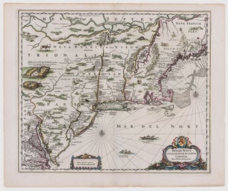
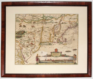
Northeast/ New York City. JANSSON, J. [Amsterdam, 1651] Belgii Novi, Angliae Novae, Et Partis Virginiae Novissima Delineatio. 17 ¼ x 20 ¼ inches. Superb original color; a few vertical creases else excellent with wide margins. .....
Northeast/ New York City. JANSSON, J. [Amsterdam, 1651] Belgii Novi, Angliae Novae, Et Partis Virginiae Novissima Delineatio. 17 ¼ x 20 ¼ inches. Superb original color; a few vertical creases else excellent with wide margins. .....
A map that is as historically important as it is attractive: it was the culmination of all the surveys conducted by the Dutch colonists of New Netherlands during their first three decades in America. It is also the first printed map to delineate the shape of Manhattan with relative accuracy;.....
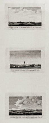
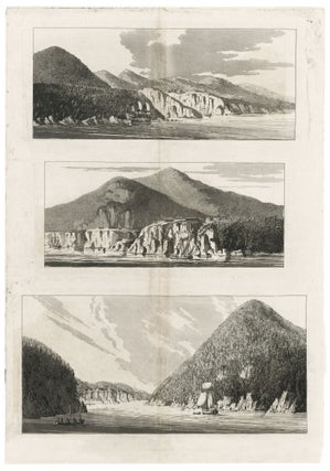
The complete set of six views (on two sheets), all relating to Boston; very rarely seen complete. These fine engravings of various vistas of Boston are important records of the area prior to as well as just after the beginning of the Revolution. Three of views show Boston itself, from.....
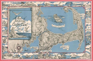
Cape Cod. MILLER, F. J. [Westwood, MA, c. 1945-1950] A Map of Interesting Cape Cod Plublished (sic) by F. J. Miller 1045 High Street Westwood, Mass. Copywright (sic) F. J. Miller Three-stone lithograph. 21 ¾ x 33 inches; with frame: 25 x 36 inches. Some fading of red border, else.....
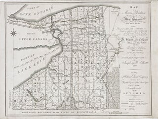
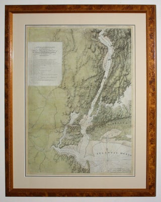
New York State/ Land Speculation. ELLICOTT, J. & B. [Philadelphia: 1801/ 1804] Map of Morris's Purchase or West Geneseo in the State of New York: Exhibiting Part of the Lakes Erie and Ontario, the Straights of Niagara, Chautauque Lake and All the Principal Waters ... Purchased by the Holland Land.....
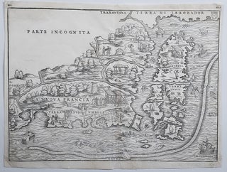
New England/ New York City. RAMUSIO, J. B./ GASTALDI, G. [Venice, 1556] La Nuova Francia. 10 1/2 x 14 1/2 inches. Woodcut map. A few minor marginal repairs, else excellent condition. .....
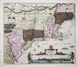
This is the most lavishly decorative of all the early editions of the best 17th century, Dutch map of the Northeast and New York. It added illustrations of animals and other detail not found on previous issues. The map was the culmination of all the surveys of the area conducted.....
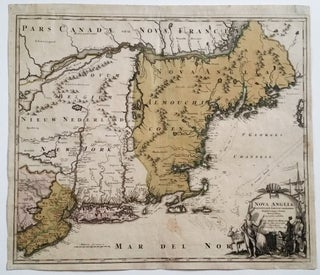
Northeast/ New Jersey. HOMANN, J. B. [Nuremberg, 1724] Nova Anglia Septentrionali Americae implantata . . . 19 ¼ x 22 ¾ inches. Fine original wash color; lightly age-toned, a few light stains, overall very good with a strong impression. .....
Forts Montgomery & Clinton/ Hudson River/ Revolutionary War. DES BARRES, J. F. W. [London, c. 1778-1781] Three Untitled Aquatints with Etching on a Single Sheet Showing the above forts from three different perspectives. Image area: 26 x 18 ½ inches. Light staining along vertical fold, else excellent condition. Extremely.....
"One of the greatest of the Atlantic Neptune charts, with the best topographical information on the lower Hudson River valley, western Long Island, and Staten Island” (Nebenzahl, Bibliography). A rare and highly evocative map that provides a cartographic overview of both the ground and naval actions of the Revolutionary War.....
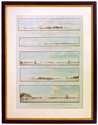
New York City/ American Revolution/ Navigation. DES BARRES, J. F. W. [London, Octr. 4, 1777] Five Profile Views from Various Points in New York Harbor, Including One Showing the City Itself. 28 x 18 ¼ inches. Aquatints with delicate, original wash color; fine condition. .....
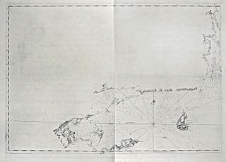
A rare and most unusual chart that provided the best mapping of eastern Long Island, including Shelter Island, and Block Island to date. That the chart was only partially finished affords us a rare look at what an 18th-century map in mid process would look like. In relatively complete form.....
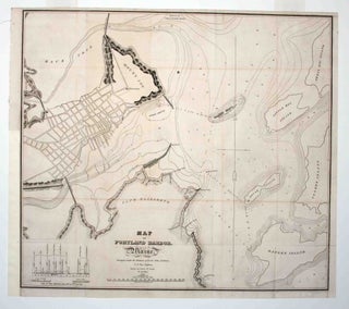
Early, detailed plan of Portland Harbor, produced to accompany a report to the 23rd Congress with regard to a proposed breakwater for the harbor. The survey was executed by Lt. Col. John Anderson at the instruction of the Secretary of War Lewis Cass; the chart itself was drawn by Lt.....
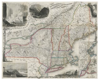
Northeast/ Canada/ Transportation History. SMITH, J. Calvin [New York: 1855/ 1858] Smith’s Rail Road, Steam Boat & Stage Route Map Of New England, New-York And Canada. By J. Calvin Smith. Published by J. Calvin Smith71 Nassau St. N.Y. MDCCCLVIII. 22 X 26 ¾ inches. Folding map, here flattened & mounted.....
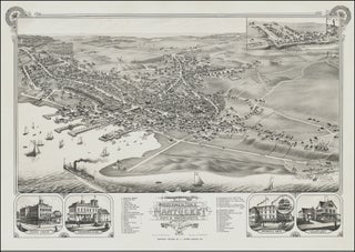
Nantucket/ Baseball History. STONER, J. J./ BECK & PAULI [Madison, WI, 1881] Bird’s Eye View of the Town of Nantucket in the State of Massachusetts. Looking Southwest.1881. 19 ¼ x 27 3/8 inches. Two-stone lithograph. Mounted on acid-free paper, invisible mends in margin and of one split entering the printed.....
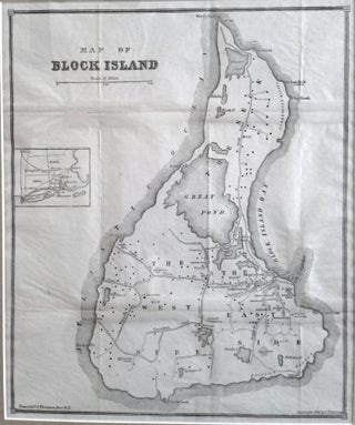
Block Island. THOMPSON, J. C. [Providence, RI: 1882] Map Of Block Island. 13 ¾ x 11 ¾ inches. Framed size: 22 x 19 inches. Lithograph. Very minor fold wear; excellent condition. [With:] Block Island. I. Map and Guide. II. Historic Sketch. Rev. S. T. Livermore [Hartford, CT: 1882] 125 pp.....