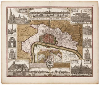
Antwerp/ Financial History. VISSCHER, C.J. /VISSCHER, N. J. [Amsterdam, c. 1630] Marchionatus Sacri Romani Imperii… C.J. Visscher Excudebat. 18 x 21 ¾ inches. Fine original color; bit of edge chipping & toning in margins, else excellent. .....
Antwerp/ Financial History. VISSCHER, C.J. /VISSCHER, N. J. [Amsterdam, c. 1630] Marchionatus Sacri Romani Imperii… C.J. Visscher Excudebat. 18 x 21 ¾ inches. Fine original color; bit of edge chipping & toning in margins, else excellent. .....
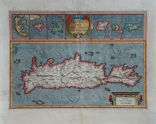
Crete/ Greek Islands. MERCATOR, G./ HONDIUS, J. [Amsterdam, 1633] Candia cum Insulis aliquot circa Graeciam. 13 ¼ x 18 ¾ inches. Fine hand color; lower margin, centerfold & cartouche at lower right reinforced, still very good overall. A very beautifully engraved and colored Dutch map from the great partnership of.....
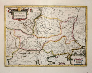
Serbia/ North Macedonia/ Bulgaria/ / Romania/ Bosnia/ Kosovo/ Albania/ Constantinople. MERCATOR, G. / HONDIUS, H./ JANSSON, J. [Amsterdam: 1636] 13 1/2 x 18 1/2 inches. Walachia, Servia, Bulgaria, Romania. Fine hand color; centerfold reinforced, else excellent condition. A detailed and attractive map of the lands surrounding the Lower Danube in the.....
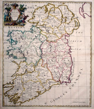
John Senex’s large folio map of Ireland, in a beautiful example with a bold strike and rich hand color. The map shows Ireland’s counties, cities and towns, waterways and loughs as expected, but includes more unusual information as well, such as the pilgrimage site of Saint Patrick’s Purgatory in County.....
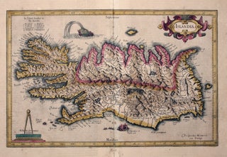
Iceland. MERCATOR, G./ HONDIUS, J. [Amsterdam, 1609] Islandia. 11 x 17 inches. Fine original color; lower centerfold reinforced, lightly toned, overall very good. .....
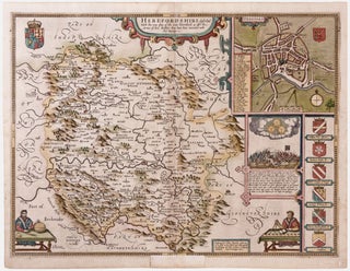
First edition and a fine example of this picturesque map evoking the rugged, forested terrain of the western English county with its many castles. At upper right is a plan of the town of Hereford with its great cathedral at the center, where is housed the legendary, medieval world map. .....
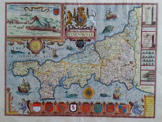
Cornwall/ England. SPEED, J./ John SUDBURY & G. HUMBLE [London, 1610 [1614?] Cornwall. 15 x 19 ¾ inches. Fine hand color; a few mended edge split, else excellent. First edition and finely colored example of Speed’s Cornwall, one of his most elaborately decorative maps. A plethora of ships, sea.....
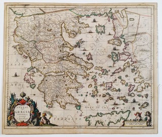
Greece/ Greek Islands. LAURENBERG, J./ JANSSON, J. [Amsterdam: 1650] Hessas. Seu Graecia Universa. Autore J. Laurenbergio. 18 ½ x 22 ¼ inches. Fine original color; lightly toned, a marginal split, else excellent. .....
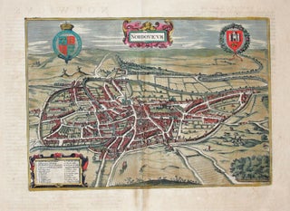
Scarce, large-paper, Jansson edition beautifully engraved, bird’s-eye view of the English cathedral city of Norwich that was also a center of the wool trade. With vibrant, full original color. From Jansson’s magnificent, eight-volume townbook atlas.
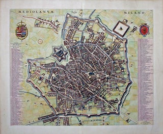
This large, oblique aerial view of Milan is certainly among the most beautiful early depictions of the city known. The city's structures are shown with considerable architectural detail, especially the larger structures such as the Duomo in center of the work. In all, 256 structures are listed and keyed to.....
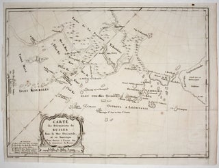
A scarce, attractively engraved map, from Russian sources, focusing on northeastern Russia, the Bering Strait and its islands, and Alaska. It appeared in M. Marbault’s Essai sur le commerce de Russie…, which is an account of Russian trade as well as a history of Russian explorations in the areas depicted.....