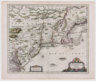
Northeast/ New York City. JANSSON, J. [Amsterdam, 1651] Belgii Novi, Angliae Novae, Et Partis Virginiae Novissima Delineatio. 17 ¼ x 20 ¼ inches. Superb original color; a few vertical creases else excellent with wide margins. .....
Northeast/ New York City. JANSSON, J. [Amsterdam, 1651] Belgii Novi, Angliae Novae, Et Partis Virginiae Novissima Delineatio. 17 ¼ x 20 ¼ inches. Superb original color; a few vertical creases else excellent with wide margins. .....
A map that is as historically important as it is attractive: it was the culmination of all the surveys conducted by the Dutch colonists of New Netherlands during their first three decades in America. It is also the first printed map to delineate the shape of Manhattan with relative accuracy;.....
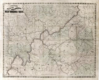
Very scarce, richly informative map showing the oil, gas and coal discoveries in West Virginia at the beginning of that region’s oil boom. The key areas along the Little Kanawha and Hughes Rivers in West Virginia and on Buck Creek in Ohio are shown in great detail. Roads, railroads and.....
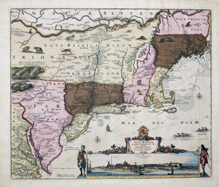
This is the most lavishly decorative of all the early editions of the best 17th century, Dutch map of the Northeast and New York. It added illustrations of animals and other detail not found on previous issues. The map was the culmination of all the surveys of the area conducted.....
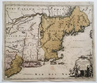
Northeast/ New Jersey. HOMANN, J. B. [Nuremberg, 1724] Nova Anglia Septentrionali Americae implantata . . . 19 ¼ x 22 ¾ inches. Fine original wash color; lightly age-toned, a few light stains, overall very good with a strong impression. .....
"One of the greatest of the Atlantic Neptune charts, with the best topographical information on the lower Hudson River valley, western Long Island, and Staten Island” (Nebenzahl, Bibliography). A rare and highly evocative map that provides a cartographic overview of both the ground and naval actions of the Revolutionary War.....