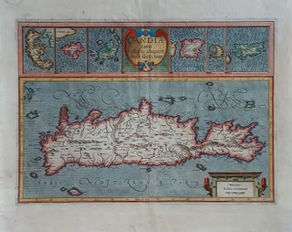
Crete/ Greek Islands. MERCATOR, G./ HONDIUS, J. [Amsterdam, 1633] Candia cum Insulis aliquot circa Graeciam. 13 ¼ x 18 ¾ inches. Fine hand color; lower margin, centerfold & cartouche at lower right reinforced, still very good overall. A very beautifully engraved and colored Dutch map from the great partnership of.....
New Arrivals
Geographic Allegorical Figures. W.B. WALKER (publisher) [London: 4 Fox & Knot Court, Cow Lane: 1805] EUROPE. ASIA. 10 ½ x 14 3/8 inches. Mezzotint, transferred to glass, finished with oil color. Sightly age-toned, small area of lower right corner chipped off, two areas of bubbling; color rich & vibrant, overall.....
Stockholm, Sweden. MERIAN, M. [Frankfurt am Main, 1638`] Stockholm. 7 ½ x 13 inches. Marginal mend well away from printed image, else excellent condition. A superb bird’s-eye view, published just after Stockholm had become the official capital of the Swedish Empire. The view is oriented to the south.....
Atlas. ORTELIUS, A./ GALLE, F. [Antwerp, 1579] Le Miroir Du Monde, Reduict Premierement En Rithme… A Anvers, De l’Imprimerie de Christofle Plantin, pour Philippe Galle. M.D.LXXIX.Oblong octavo in contemp. Vellum, ties lacking; 72 maps, 6 of which folding; slight edge wear to text leaves, partial cropping to some folding maps for.....
Map Of The Balkan Peninsula….
A rare, clearly printed, political map of this volatile region, described as "entirely new" in the advertisement included here. Although the map is not dated, the Royal Geographic Society reported its acquisition of an example in July of 1914 (see below). Since the Archduke Franz Ferdinand was assassinated on June.....
Portugalliae et Algarbiae Regna.
Superb original-color example of this large, ornate map of the kingdom of Portugal, with an inset map of the kingdom’s former colonies in Brazil. The allegorical cartouche alludes to Portugal’s profitable history of exploration. To the left, Neptune astride his chariot, showing dominance over the sea. To the right, Europa.....
Regiae Celsitudinis Sabaudicae Status in quo Ducatus Sabaudiae Principat. Pedemontium ut et Ducatys Montisferrati….
A very attractive map of a geo-politically very important area at the time that encompasses northwestern Italy and southeastern France and includes the cities of Milan, Genoa, Turin, Nice, Grenoble as well as Monaco and the French Alps including Chamonix. In its beautiful allegorical cartouche, putti representing Armenia, Sardinia, Jerusalem.....
Pianta Topografica Della Citta Di Roma Dell' Anno 1829.
A finely engraved plan of Rome flanked by 15 floor plans of the city's most important structures, both ancient and more recent. It was likely intended for the more serious-minded visitor, such as northern Europeans on the Grand Tour, and for students of architecture. Pietro Ruga was active in the.....
Pianta Della Citta Di Roma Con La Indicazione Di Tutte Le Antichita E Nuovi Abellimenti.
Large, attractively engraved plan of Rome, flanked by 16 vignettes, each approximately 4 x 5 inches, of the city's most prominent ancient and modern structures. Included among the latter are the Pantheon of Agrippa, Trajan's Column, and the Colosseum; among the former are the basilicas of St. Peter, St. John.....
Serbia/ North Macedonia/ Bulgaria/ / Romania/ Bosnia/ Kosovo/ Albania/ Constantinople. MERCATOR, G. / HONDIUS, H./ JANSSON, J. [Amsterdam: 1636] 13 1/2 x 18 1/2 inches. Walachia, Servia, Bulgaria, Romania. Fine hand color; centerfold reinforced, else excellent condition. A detailed and attractive map of the lands surrounding the Lower Danube in the.....
Eur: IX Tab:.
The very scarce, first state of this attractive map engraved by Gerard Mercator himself of what is today northwest Turkey, including Istanbul (here Byzantium) and the Dardanelles. Also on the map are present-day northern Greece, Macedonia, Albania, Bulgaria, Romania, Kosovo and Serbia. Meeting in this map are two of the.....
Prospectus Pontis Westmonasteriensis Londini/ Viso Del Ponte De Westmiinster a Londra.
A beautifully engraved, lively view of London with Westminster Bridge in the foreground. The Thames River teems with sailboats and river barges. The old Westminster Palace’s river steps can be seen at the right-hand foot of the bridge, and St. Paul’s Cathedral can be seen in the distance to the.....
Cyprus Insula.
One of the finest early maps of Cyprus in a beautiful original-color example. Its magnificent cartouche portrays Venus, pulled on a sea-chariot by two swans, accompanied by Cupid (distinguishable from an ordinary putto by the arrow he brandishes.) The waters around the island are embellished with three ships, two compass.....
Europ: III Tab:.
A scarce, early issue, the second overall, from Mercator’s definitive edition of Ptolemy’s geography. The map shows France as it was known in the Roman Imperial period. It was based on geographic data and mapmaking instructions left by Alexandrian astronomer and geographer, Claudius Ptolemy (fl. A.D. 127-180), whose work laid.....
A New Map of Ireland….
John Senex’s large folio map of Ireland, in a beautiful example with a bold strike and rich hand color. The map shows Ireland’s counties, cities and towns, waterways and loughs as expected, but includes more unusual information as well, such as the pilgrimage site of Saint Patrick’s Purgatory in County.....
Untitled Globe Gore.
A gore (constituent globe part) by the greatest early globe maker, showing the Azores and Cape Verde island groups. Tracks of various 17th century European voyages headed to the East Indies, which used these islands as way stations, are plotted out, with their positions for particular dates indicated. In the.....
de Cust van Barbaryen.
Fine, early chart of the Barbary Coast--the pirate haven along the southwestern coast of Morocco. The two primary horizontal charts cover from Safi in the north to Cap Blanc in the south. At the bottom of the chart are three insets: of the Madeira Islands, of Angra, the primary city.....