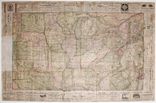
United States/ New York State/ Railroads/ Advertising. HANNIFAN & CO., Publisher/ RAND MCNALLY, Printer [New York, 1886] 1885.-Railroad Map And Business Guide in Book Form.-1886.Embracing the Principal Manufacturers, Trades and Representative Business House of Utica, Rome Camden..and Schenectady. 25 ½ x 39 ½ inches. Lithographed folding map with original hand.....
New Arrivals
Results 1 - 3 (of 3)
Bancroft's Map of California, Nevada, Utah and Arizona,
A bright, vibrant example of a map of California and the western states by "the greatest map publisher of the Pacific Coast" (Wheat). The map descended from what Wheat called "the great 'map of the Pacific states'"--that of William H. Knight, published in 1863, also by the Bancroft firm. The.....
Course of the River Mississippi from the Balise to Fort Chartres.
Tall, striking work based on the first official survey of the lower Mississippi River done in 1763. The map extends north to just below St. Louis. It provides considerable detail for the New Orleans area and shows Baton Rouge and Lake Pontchartrain. The map is significant for its delineation of.....
Results 1 - 3 (of 3)