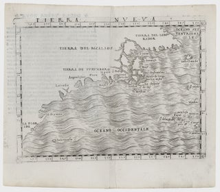
Northeast-Southeast/ New York City/ Bermuda. GASTALDI, G. [Venice, 1548] Tierra Nueva. 5 1/4 x 6 3/4 inches. A fine example with an uncommonly strong impression. .....
Northeast-Southeast/ New York City/ Bermuda. GASTALDI, G. [Venice, 1548] Tierra Nueva. 5 1/4 x 6 3/4 inches. A fine example with an uncommonly strong impression. .....
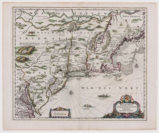
Northeast/ New York City. JANSSON, J. [Amsterdam, 1651] Belgii Novi, Angliae Novae, Et Partis Virginiae Novissima Delineatio. 17 ¼ x 20 ¼ inches. Superb original color; a few vertical creases else excellent with wide margins. .....
A map that is as historically important as it is attractive: it was the culmination of all the surveys conducted by the Dutch colonists of New Netherlands during their first three decades in America. It is also the first printed map to delineate the shape of Manhattan with relative accuracy;.....
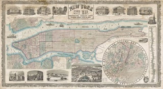
PHELPS, Humphrey [New York: 1857] Phelps' New York City Map, With Portions of Brooklyn, Jersey City, Williamsburgh, Greenpoint, Astoria, and Hoboken… 25 x 45 ¾ inches. 25 x 45 ¾ inches. Lithographed wall map with fine original color, refreshed; professionally conserved & re-backed, with some stabilized tears and a few.....
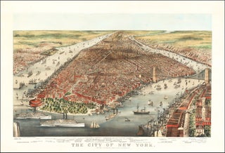
Brooklyn Bridge/ New York City. CURRIER & IVES/ PARSONS & ATWATER (artists & lithographers) [New York: 1876] The City of New York. 22 x 33 ¼ inches. Color lithograph; mounted on heavy stock; a few minor abrasions, else fine condition. A breathtaking bird’s-eye view capturing the dynamism and animation of.....
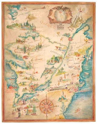
Pictorial Map/ United States/ Canada. CASS, Katherine "Kae" Dorn [Cleveland, Ohio: 1928] Untitled Manuscript of the Northeast & Midwest U. S. & Part of Canada. 26 ¾ x 21 inches. Watercolor & ink on poster board; excellent condition. Highly animated and well-executed biographical map chronicling the travels, activities, adventures and.....
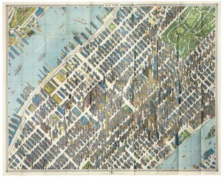
New York City/ Architecture/ Graphic Arts. BOLLMANN, H. [New York, 1963 [1964]New York Map-Guide. 33 ¾ x 44 ½ inches. Color-printed folding view of Midtown with a regional map on the verso, with original covers containing a 48 pp. booklet. Very slight fold wear to map, else excellent. .....