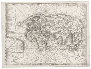
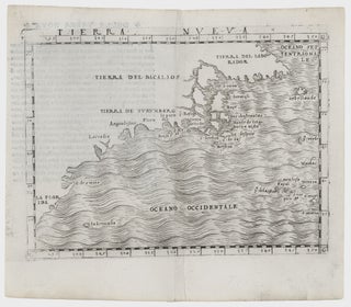
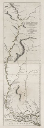
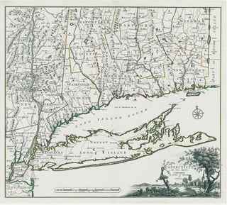
New Arrivals
Norumbega Et Virginia.
A very early and revealing map of the Northeast and Mid-Atlantic regions at the time of initial colonization. "A superbly executed engraving, [the map] depicts the northeastern American coastline as it was perceived by European geographers one hundred years after the discovery of the New World. [It] marks the approximate.....
World/ Northwest Passage/ Australiana. KEERE, P. VAN DEN/ JANSSON, J. [Amsterdam, 1621/c. 1636] Totius Terrarum Orbis Geographica ac Hydrographica Tabula. 15 1/2 x 21 inches. Fine hand color; a few mended, inconspicuous into engraved surface & along a vertical crease, largely in margins, good overall. .....
Novi Belgii Novaeque Angliae.
A map that is as historically important as it is attractive: it was the culmination of all the surveys conducted by the Dutch colonists of New Netherlands during their first three decades in America. It is also the first printed map to delineate the shape of Manhattan with relative accuracy;.....
Portugalliae et Algarbiae Regna.
Superb original-color example of this large, ornate map of the kingdom of Portugal, with an inset map of the kingdom’s former colonies in Brazil. The allegorical cartouche alludes to Portugal’s profitable history of exploration. To the left, Neptune astride his chariot, showing dominance over the sea. To the right, Europa.....
Course of the River Mississippi from the Balise to Fort Chartres.
Tall, striking work based on the first official survey of the lower Mississippi River done in 1763. The map extends north to just below St. Louis. It provides considerable detail for the New Orleans area and shows Baton Rouge and Lake Pontchartrain. The map is significant for its delineation of.....
1. A View of Boston from Dorchester Neck. 2. Long Island . . . 3. Boston from Willis Creek. 4. A Front View of the Lines taken from the advanced Post near Browns House. 5. A View of the Harbour of Boston taken from Fort Hill. 6. A View of the Country towards Dorchester, taken from the advanced works on Boston Neck.
The complete set of six views (on two sheets), all relating to Boston; very rarely seen complete. These fine engravings of various vistas of Boston are important records of the area prior to as well as just after the beginning of the Revolution. Three of views show Boston itself, from.....
Connecticut. ROMANS, B./ COVENS & MORTIER & COVENS [Amsterdam, 1780] Connecticut and Parts adjacent… 20 ½ x 23 ¼ inches. Copperplate engraving with original outline color; all edges deckled, uncut; mint condition; in a fine archival frame. Very rare; separately published. The earliest acquirable map of Connecticut.....
Untitled Nautical Chart.
A rare and most unusual chart that provided the best mapping of eastern Long Island, including Shelter Island, and Block Island to date. That the chart was only partially finished affords us a rare look at what an 18th-century map in mid process would look like. In relatively complete form.....
FIRST VIEW of the BATTLE of PATAPSCO NECK [:] DEDICATED TO THOSE WHO LOST THEIR FRIENDS IN DEFENCE OF THEIR COUNTRY [:] SEPTR 12 1814.
Extremely rare, unrecorded proof (or first) state, by an American participant, of the September 1814 Battle of North Point, at which Maryland militia stoutly defended Baltimore against a large force of British regulars. The early land campaigns of the War of 1812 took place along the Canadian border, but in.....
Plat of Navarino Green Bay, Wisconsin Territory. 1836..., Daniel Whitney, Joshua Whitney, Henry Hamilton - Proprietors. A. E. Baker’s Lithogry. 8 Wall St. N. York, 1836.
Very rare. Green Bay, Wisconsin's seminal map, Ellis' plan shows the town as it was originally laid out, extending from the Fox River east to present North Irwin Avenue, and from Walnut Street north to present Eastman Street. All the surveyed blocks are divided into numbered lots, with two public.....
United States/ Cartographic Curiosity. BOYNTON, George W. (engraver)/ TUTTLE, Joseph Willard (publisher) [Boston: Tremont Print Company: dated 1841] A MAP OF THE UNITED STATES, FROM THE LATEST SURVEYS. WITH THE HEIGHT OF MOUNTAINS And length of the PRINCIPAL RIVERS. PATENT. 25 3/4 x 25 inches (image not including margins). Lithographed map.....
Cuba/ Opera History. CARDENA, Mariano/ BECHERINIE, F. [Havana, 1848] Arribo de Albina Steffanoni a la Isla de CUBA. 1848. 8 x 11 inches (sheet size). Manuscript in pen & ink & watercolors on heavy, watermarked wove paper, bit of soiling & toning, else excellent. [With:] A ms. sonnet titled Omaggio.....
Connecticut. NEVERS, R./ DAMERUM, W. [Hartford, 1851] The State of Connecticut including Parts of New York and New Jersey. 23 x 28 ¼ inches (engraved area only. Original wash hand color, refreshed; re-mounted on new linen & expertly conserved; toned, some spotting, a few splits but overall very good. In.....
Map of the Towns of Saybrook and Old Saybrook Middlesex County Connecticut.
A beautifully preserved wall map, in very attractive, period wash coloring, of the lower Connecticut towns of Old Saybrook, Essex, Deep River, Centerbrook and Ivoryton, located at or near the mouth of the Connecticut River on the eastern side. The overall map is complemented with plans of the central areas.....
Two sheets: America West Cape Mendocino to Vancouver Id. from Cape Flattery southward... [and] America West Diego Bay to Cape Mendocino.
Scarce, finely engraved chart on two sheets of the entire west coast of the United States and including the southern portion of Vancouver Island. Each of the 27 coastal recognitions on the charts is delicately realized. These provided visual reference for the entry to the major bays and ports as.....
Xapthe The Amepikhe Ek Toy Ataantoe Toy….
A very rare, Greek cartographic imprint in a separately published example. We located a copy of the map at the Library of Congress but not elsewhere, either in institutional collections or in market records. Cf. Tooley's Dictionary K-P, p. 102.