![Item #10631 Two sheets: America West Cape Mendocino to Vancouver Id. from Cape Flattery southward... [and] America West Diego Bay to Cape Mendocino. BRITISH ADMIRALTY/ J., C. WALKER-engravers.](https://rtamaps.cdn.bibliopolis.com/pictures/10631.jpg?width=768&height=1000&fit=bounds&auto=webp&v=1588173041)
click here to zoom
![Two sheets: America West Cape Mendocino to Vancouver Id. from Cape Flattery southward... [and] America West Diego Bay to Cape Mendocino...](https://rtamaps.cdn.bibliopolis.com/pictures/10631_2.jpg?auto=webp&v=1585677025)
![Two sheets: America West Cape Mendocino to Vancouver Id. from Cape Flattery southward... [and] America West Diego Bay to Cape Mendocino...](https://rtamaps.cdn.bibliopolis.com/pictures/10631_3.jpg?auto=webp&v=1585677025)
![Two sheets: America West Cape Mendocino to Vancouver Id. from Cape Flattery southward... [and] America West Diego Bay to Cape Mendocino...](https://rtamaps.cdn.bibliopolis.com/pictures/10631_4.jpg?auto=webp&v=1585677025)
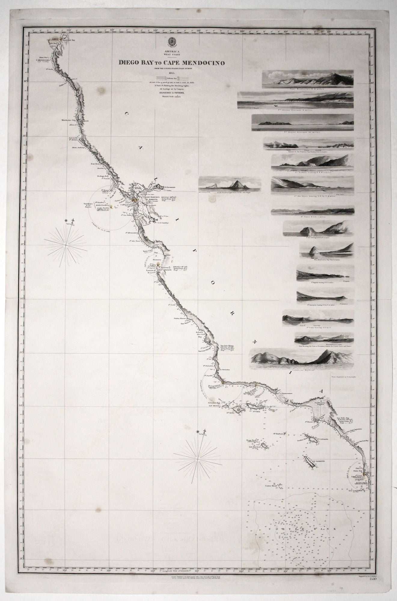
Two sheets: America West Cape Mendocino to Vancouver Id. from Cape Flattery southward... [and] America West Diego Bay to Cape Mendocino.
Each, 38 1/2 x 25 1/4 inches, Engraved with lighthouses colored by hand. On heavy paper, slight spotting, southern sheet reinforced fold split, else excellent condition.
Scarce, finely engraved chart on two sheets of the entire west coast of the United States and including the southern portion of Vancouver Island. Each of the 27 coastal recognitions on the charts is delicately realized. These provided visual reference for the entry to the major bays and ports as well as depict important landmarks along the way. They were the work of Edward Radclyffe (1810-1863), who was primarily known as a skilled landscape engraver, who provided vignettes for several maps. As is evidence by his work here, he was artistically trained and won a medal for etching in 1824.
The charts were mostly based on surveys by the U. S. Coast Survey. There is excellent detail for Strait of Juan de Fuca, Puget Sound and the San Juan Islands, based on 1847 surveys by Capt. Kellet of the Royal Navy. Topography along the entire coast is nicely rendered. The engravers of the chart, John and Charles Walker, had a long and very productive association with the British Admiralty as well as prolific publishers on their own. John also worked with the East India Company and was a founding member of the Royal Geographic Society in 1830.
* Worms & Baynton-Williams, British Map Engravers, pp. 542-43, 690, 692-94
Price: $2,800.00