
click here to zoom
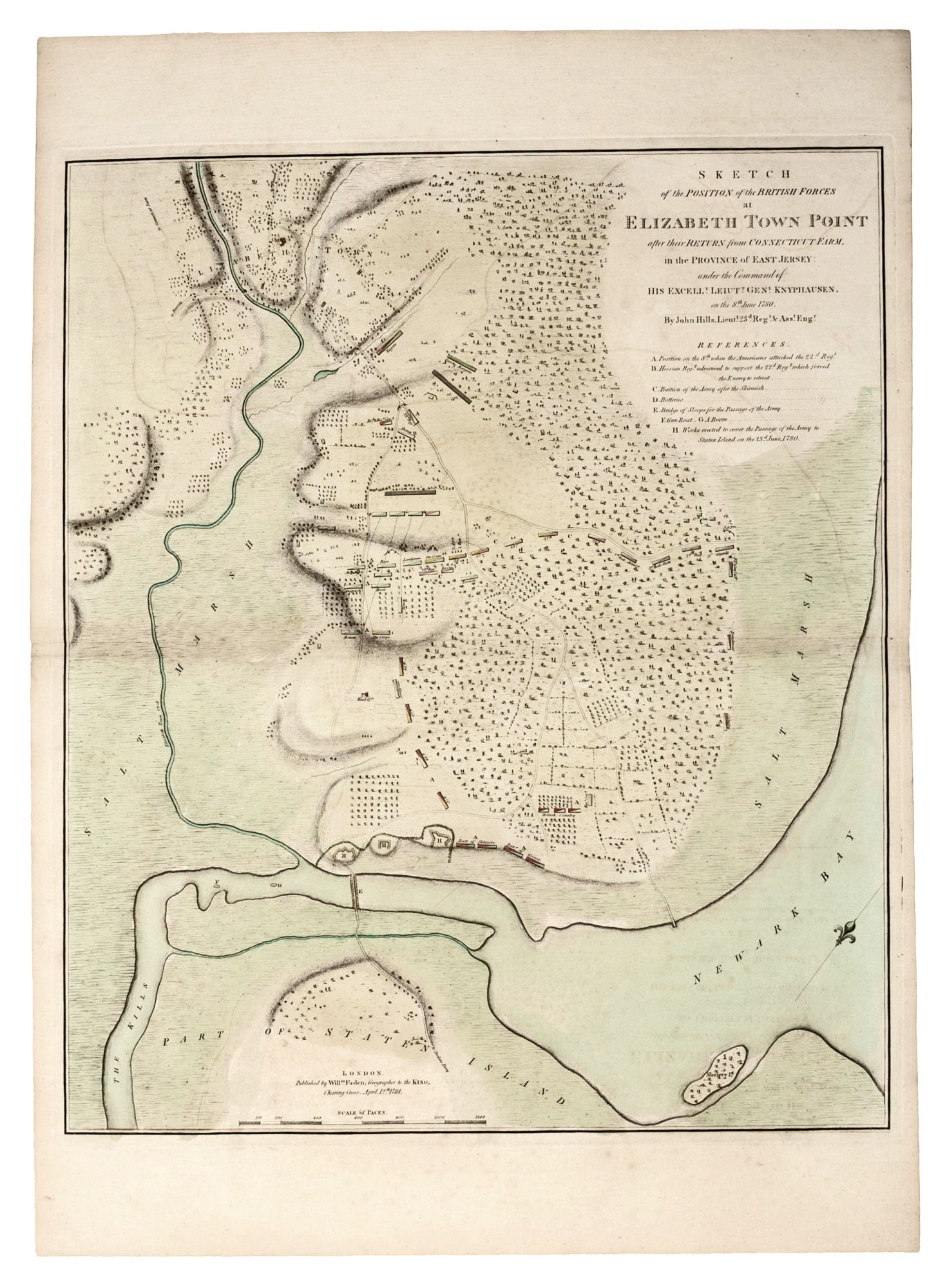
Sketch of the Position of the British Forces at Elizabeth Town Point after their Return from Connecticut Farm, in the Province of East Jersey….
24 x 20 ¼ inches. Full original wash color; slight offsetting & discoloration along fold, else excellent. A superb example of this rare and finely engraved plan of the Battle of Elizabeth Town, New Jersey, after a manuscript by the great military cartographer John Hills. The work chronicles one of the rare engagements in the New York/ New Jersey area of the protracted middle period of the Revolution. This is one of only a few early printed, Revolutionary War battle plans relating specifically to New Jersey. Offered here is the original edition of the map; there was also a mid-19th century re-strike. The engagement depicted in this work, called the Battle of Elizabeth Town, consisted of two phases fought on June 8 and 23, 1780, during the last major British campaign in the northern theatre of the American Revolution. It occurred on fields that lay to the south of the village of Elizabeth Town (today known as Elizabeth), a position bordered on three sides by salt marshes and water. In the Spring of 1780, the British held all of Manhattan, while New Jersey was controlled by American forces headquartered in Morristown. However, the situation remained both tense and fluid, as the British were always on guard for an American invasion of Manhattan, while the Americans were ever vigilant for enemy attacks from across the Hudson. Lieutenant General Wilhelm von Knyphausen (1716-1800), a Hessian Baron who served as the British commandant of New York, decided to launch an invasion of New Jersey. His force of 6,000, mostly German mercenaries, encountered sharp resistance at Connecticut Farm, New Jersey, from a smaller but highly motivated American force under General Nathaniel Greene. Nevertheless, Knyphausen was able to proceed to Springfield Bridge, but the Americans managed to check him and to force him to retreat to the area of Elizabeth Town. The action portrayed on the map begins on the morning of June 8, 1780 with the depiction of Knyphausen's lines assembled in a defensive position as if to ward off a siege (as indicated by 'A' on the map). With the various British regiments carefully labeled and color coded, the map indicates how Knyphausen's lines were forced to contract inwards in response to an American assault. However, the arrival of reinforcements (B) saved the British from having to give up further ground and enabled them to eventually occupy a better position on elevated land. Despite this lackluster performance, the British force remained a viable threat, as Washington's army in Morristown was ill-prepared to face a well-orchestrated British assault. On June 23, the British again encountered the Americans at Springfield Bridge, but this time the former were decisively defeated, forcing them to make a hasty retreat to the relative safety of Staten Island across the improvised bridge depicted on the map (E). In sum, the British at Elizabeth squandered a real opportunity to gain control of New Jersey and thus threaten Washington's plans to conclude the war on American terms. The map is based on a now lost manuscript by John Hills, one of the most talented and prolific cartographers of the Revolutionary War, and a direct eyewitness to many of the events depicted on his maps. John Hills ( fl. 1777-1816) served as Ensign in the 38th Regiment and later as a lieutenant in the 23rd. His abilities were greatly valued by his superiors even though his mercurial personality frequently led him into violent altercations with fellow officers and civilians alike. Hills was an important figure in New Jersey cartography in other respects. He seems to have been in contact with various local surveyors in both New Jersey and Pennsylvania. His greatest work was the manuscript atlas of 20 maps of parts of New Jersey he made in 1780 for the British Commander-in-Chief, Sir Henry Clinton, now preserved in the Library of Congress. Included in this atlas is a "Plan of the road from Elizabeth Town Point to Elizabeth Town: shewing the rebel works raised for its defence," which shows the battle site immediately prior to the first action of June 8, 1780. This map was surely used in the preparation of the manuscript on which the present map is based. Following the war, Hills settled in Philadelphia, and existing manuscripts show that as early as 1788, he was working as professional draftsman and surveyor. In 1796, with the support of Philadelphia's mayor, Matthew Clark, Hills completed the most important survey of the city of the Post-Revolutionary generation. This was published as A Plan of the City of Philadelphia and its Environs (London, 1798), and is today a landmark of early American urban cartography. William Faden (1749-1836), the Geographer to the King, ascended to the apex of the London map world based on his groundbreaking cartography of the American Revolution. Faden included the present map in his exceedingly rare Atlas of Battles of the American Revolution (London, 1784), although some examples were also issued separately.
* Guthorn, British Maps of the American Revolution, 57/16 & 43; Nebenzahl & Higginbotham, Atlas of the American Revolution, map 33; Nebenzahl, Bibliography of Printed Battle Plans of the American Revolution, no.146; cf. Augustyn/ Cohen, Manhattan in Maps, pp. 88-89.
Sold