click here to zoom
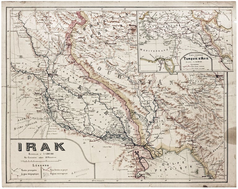
Iraq/ World War I. PERVITITCH, Jacques [Jakub PERVITIĆ] [Constantinople: c. 1918] Irak. 18 ½ x 23 inches (47 x 58.5 cm. Color lithography, with some contemporary manuscript additions in pencil, bearing stamp of "J. Pervititch Constantinople." Mended marginal split, a few penetrating printed surface, some staining & creasing, yet still very good for a separate publication. Iraq and the neighboring regions of southwestern Persia were of tremendous geopolitical importance during World War I and in its aftermath. In 1907, the declining Qajar Dynasty agreed to place all Southern Persia under British suzerainty, whereupon it became the focus of operations of the Anglo-Persian Oil Company (later British Petroleum). Ottoman Iraq, likewise, rich in oil, also strategically hosted a key section of the telegraph lines that connected Britain to India. During the Mesopotamian Campaign (1915-18) of World War I, British Imperial attempts to conquer Iraq initially met with disastrous failure at the hands of Ottoman forces. However, by 1917, the tables were turned, and by the end of the war the country was in British hands. The victorious Entente powers had agreed that following the war Iraq would become a British mandate, or an Arab-ruled protectorate with an undetermined degree of autonomy. Britain very much coveted the oilfields of the Basra region, while seeking to solidify its dominance over the Persian Gulf. For a time, the fate of the former Mosul Vilayet was up in the air; the emerging Turkish state lobbied to retain the region, while British interests converted its vast oil wealth. Notably, few considered the interests of the region’s Kurds. Interestingly, in neat manuscript lines in pencil, on both the main map and the inset map, proposed boundary lines are traced between the emerging new state of Turkey and Mandate Iraq. These lines show Turkey retaining most of the Mosul Vilayet and were likely made by a pro-Turkish individual in Constantinople during the period when the boundaries were actively subject to debate. In 1921, after much diplomatic wrangling, Mosul Vilayet was added to Mandate Iraq, largely confirming the country’s modern boundaries. Iraq gained its independence from Britain in 1932. The map's legend in the lower left corner identifies symbols for the principal roads, telegraph lines, swampy areas, and projected railways. Most importantly, it shows the planned route of the Baghdad Railway, the German-financed line that was intended to run from Constantinople to Baghdad (here also showing the possible extensions to Basra and even Kuwait). The inset map, in the upper right corner, ‘Carte d’ensemble de la Turquie d’Asie’, shows the greater region with international boundaries as they existed at the beginning of World War I. The railway networks are delineated, both as they existed and as they were projected, serving to emphasize Iraq’s crucial geopolitical location. Jacques Pervititch was born Jakub Pervitić in Močići, just south of Durbrovnik, Dalmatia, the son of a sea captain. His family moved to Constantinople in 1880, where he grew up immersed in Pera’s Francophone Roman Catholic community. Pervititch is best known for creating what is inarguably one of the most impressive works of urban cartography of the 20th century, the Plan cadastral d’assurances…de la ville de Constantinople, a 243-sheet set of insurance maps of Istanbul, produced in various editions from 1922 to 1945. These phenomenally precise maps detailed every property in the entire city and formed the bedrock of administrative planning in Turkey’s great metropolis until the 1950s. Moreover, Pervititch was known to have created a small number of maps of other subjects, produced in small print runs in a ‘boutique’ fashion, such as the present map. All these works are today exceedingly rare. N / A – Seemingly Unrecorded. Cf. Musemma Sabancioğlu, ‘Jacques Pervititch and his Insurance Maps of Istanbul’, Dubrovnik Annals, no. 7 (2003): pp. 89-98.
An apparently unrecorded, separately-issued map of Iraq, Kuwait and southwestern Iran, published towards the end of World War I in Constantinople by the important Croatian-Turkish cartographer, Jacques Jacques Pervititch (Jakub Pervitić) (1877-1945). This geo-politically interesting work captures what would have been Turkey’s preference in the creation of what would soon become modern Iraq. This attractive map was published as the Ottoman Empire was on the eve of its collapse.
Price: $1,500.00