click here to zoom
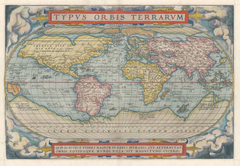
World. ORTELIUS, A. [Antwerp: 1570 [1574] Typvs Orbis Terrarvm. 13 ¼ x 19 ¼ inches. Copperplate engraving with fine hand color; invisible split along top of centerfold, supported with thin rice paper on verso, overall very good A very attractive example of an early issue of the first edition of the stately world map that appeared in the first standardized atlas; it provided the conception of the world that would prevail for many decades to follow. Using the freshest information available, Ortelius employed as his chief source Mercator’s profoundly important world map of 1569, on which was introduced the eponymous projection. Since only three copies survive of Mercator’s map, it was through Ortelius’ rendering of it that the master’s advanced geography became more generally available. While using Mercator’s geography, Ortelius did not employ his projection, as the mathematics for implementing it would not be well understood until decades later. An important geographic feature of the map is the wide, enticing Northwest Passage across the north part of America, which encouraged a number of fruitless English voyages of exploration in this area. Both Frobisher and Drake are believed to have had copies of Ortelius' atlas with them on their voyages. The eastern seaboard of the United States is still quite crudely delineated on the map, taking a radical west-to-east turn in the area of the Carolinas. Likewise, South America is distorted in the famous "potato" shape. Africa, on the other hand, is quite well formed. Japan appears in the "kite" shape, one of the four distinctly different delineations of the country to be found in Ortelius's atlas. The Southern Hemisphere is dominated by a vast continent, here labeled Terra Australis Nondum Cognita but also known as Magellanica. As it is depicted in this map, Magellanica was thought to include the land now known as Australia in the Eastern Hemisphere and Tierra del Fuego in the West. Shirley no. 122, pl. 104, state 1; van den Broecke Ort 1: 1574 L1, p. 70; van der Krogt 0001:31:012.
Sold