click here to zoom
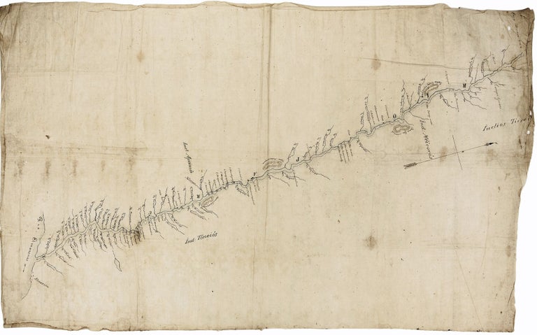
This remarkably detailed and precise map of the Paru River, a northern tributary of the Lower Amazon in Pará State, was clearly the result of a thorough exploration of the river. There is a strong probability that it was in some manner associated with the much-honored French explorer, Jules Crevaux (1847-1882), who in 1878, during the second of his four major explorations in South America, is known to have explored the Paru River. We are not aware of any other explorations of the river in the 19th century. Crevaux explored some of the remotest regions of French Guiana and northern Brazil as well as other locales in South America. Although the language used on the map is Portuguese, it is certainly more than possible that the cartographer on Crevaux's expedition was either Brazilian or Portuguese. A positive identification of this map would require the examination of other maps associated with Crevaux, if indeed such exist. The fact the map is on silk and shows evidence of folds indicate it was made for portability and hence use in the field. Moreover, the place names on the map are in at least two clearly different hands, suggesting it may have been used and then updated. In any case, its level of detail for this still remote region is remarkable.
Paru River/ Almeirim/ Brazil. CREVAUX, Jules? [Brazil?: c. 1878] Untitled & unsigned manuscript map of the Parú River in pen & ink on silk. 840 x 500mm (33 x 19 ¾ inches). Lightly age-toned, creasing and old folds, two or three holes in blank areas, very good.
The Paru River intersects with the Amazon at the town of Almeirim. The map's extensive annotations include the river's numerous tributaries, houses and settlements, waterfalls and bordering hills, and the names of Indian tribes (Apana, Toneios, Meicoros and Tiereis (?)) along its course. The river flows through the 'moist forest' area of the Uatuma-Trombetas eco-region and the Maicuru Biological Reserve.
Price: $1,950.00