click here to zoom
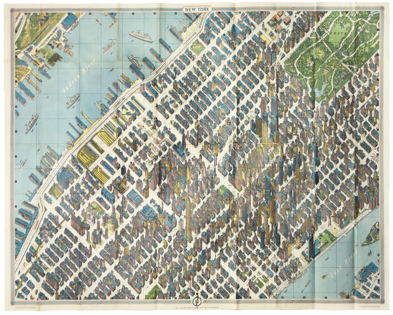
New York City/ Architecture/ Graphic Arts. BOLLMANN, H. [New York, 1963 [1964]New York Map-Guide. 33 ¾ x 44 ½ inches. Color-printed folding view of Midtown with a regional map on the verso, with original covers containing a 48 pp. booklet. Very slight fold wear to map, else excellent. A masterpiece of modern cartographic art displaying Midtown Manhattan at the pinnacle of the Age of the Skyscraper. Bollmann created an image of remarkable precision, while employing subtle distortion and exaggeration to emphasize scale and clarity. The entire work was originally drawn by hand, and its preparation boasted the use of over 67,000 photographs, 17,000 of which were aerial. Rather than rely entirely on photorealism, Bollmann widened the streets to keep the image uncluttered; his view dispenses with perspective to maintain a uniform scale for all the buildings and allow comparison of size. Color is judiciously used to help the viewer to visually differentiate structures. The result captures the highest concentration of skyscrapers in the world of its day, presenting each with its uniquely recognizable profile: the iconic Empire State building, the graceful Art Deco curves of the Chrysler building, the sleek blade of the United Nations, and the ultra-modern helicopter pad of the Pan Am building. The work’s exactitude extends to the shorelines, and although a relatively small extent is shown, it nevertheless provides a valuable record of piers and structures, most now gone, in this area. Also, even some cruise ships are rendered in detail and named in the Hudson River. A mammoth version of this map was displayed at the 1964 World’s Fair; this example (as is the case with most available on the market) was one of those sold before and during the Fair for both promotion and as a guide to the city. Corporate and business sponsors of the of the Bollman Map-Guide had their businesses indicated in the body of the view. American Airlines was the primary sponsor of the work, so its ticket offices can be found marked throughout the view, and a sharp eye will find B. Altman’s department store, kitty-corner from the Empire State Building. (Many antique map collections had their beginning with purchases made on the eighth floor of that storied building.) The accompanying booklet is vivid expression of American dynamism and confidence of the period. It provides a history of New York City in French, Spanish and Japanese as well as English. It provides the visitor with the full range of information about the city, including a section on “Famous American Companies.” This issue of the map, lithographed in New York by Barnes Press, is bolder and more attractive than the contemporaneous edition printed by Verlag Busche in West Germany. Augustyn, R. T., Cohen, P., Manhattan in Maps 152 - 153.
Price: $450.00