click here to zoom
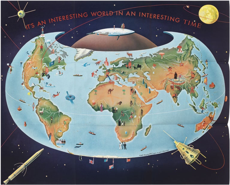
World Map. CHAPIN, Robert MacFarlane/ DONOVAN, Jeremiah. New York: TIME Inc., 1959] IT’S AN INTERESTING WORLD IN AN INTERESTING TIME. 24 ½ x 30 inches. Poster printed in color halftone; folds for mailing as issued, else excellent. A striking pictorial map from the Cold War period and early years of the Space Race evoking the zeitgeist of the period. The downright strange map utilizes cartoonishly light-hearted graphics to depict some quite frightening developments at the time—atomic explosions in Russia and the American Southwest, oversized space craft surrounding the earth, and a fist-raising Khrushchev menacing Europe. The map’s weirdly cheery style seems to reflect a sense of obligation felt by American media at the time to allay the anxieties of the age. The used the unusual “armadillo” projection, developed by Erwin Raisz in the 1940s, enabling them to depict the Earth as if viewed from space, yet still showing the vast majority of its surface. Dozens of vignettes scattered across the map offer a range of cultural, political, and historic references, with some merely stereotypical but many reflective of the times. World leaders are scattered across their respective countries with President Eisenhower in the U.S., Premier Khrushchev in the U.S.S.R., Prime Minister Nehru in India, President Nasser in Egypt. A woman, apparently standing atop the Pacific, holds up a star representing Hawaii’s accession to statehood in August of 1959. Africa and even South America are seen on the map through largely colonialist eyes. The choice of projection also enabled the artists to put terrestrial events in the context of the Space Race, which arguably began in 1955, when both the U.S. and Soviet Union declared their intentions to launch competing artificial satellites. Accordingly, the American Vanguard 1 and Explorer 1 satellites, along with the Soviets’ Sputnik 3, are shown in orbit. Mapmaker Robert MacFarlane Chapin graduated from the University of Pennsylvania in 1933 with a degree in architecture. Finding little demand for his training during the Depression, he took a job as a retoucher of photos at Newsweek, where he somehow learned to draw maps. In 1937 he was lured away to run the map department at Newsweek rival TIME, where he worked for the next 33 years. He and his team were extremely prolific, particularly during the Second World War, when they produced four, five and six maps per week to keep up with breaking news. After the War Chapin remained at TIME for another quarter century, during which period he produced numerous maps, including many addressing aspects of the Cold War, a titanic “us vs. them” struggle to which his bold style and liberal use of red were well suited. “The Time-Chapin association, extending over almost two decades, has been one of the major pillars of American journalistic cartography. Chapin maps have established a pattern and style for modern newsmagazine cartography” (Ristow, p. 384). Chapin’s maps were enormously popular, and they were often enlarged and reprinted in poster format for distribution to schools. Artist Jeremiah Donovan (1916-1982) studied at the Pratt Institute and the Art Students League in New York before working as a freelance artist for Time, Inc. in 1946. In 1951 he was hired on as a staff cartographer and artist, and he succeeded Chapin as the head of Time’s cartography department, retiring in 1973. Over his career, more than 1300 of his drawings were published in Time Magazine, and his work was highly sought by commercial firms. Hornsby, Picturing America, p. 245, plate 157.
Sold