
click here to zoom
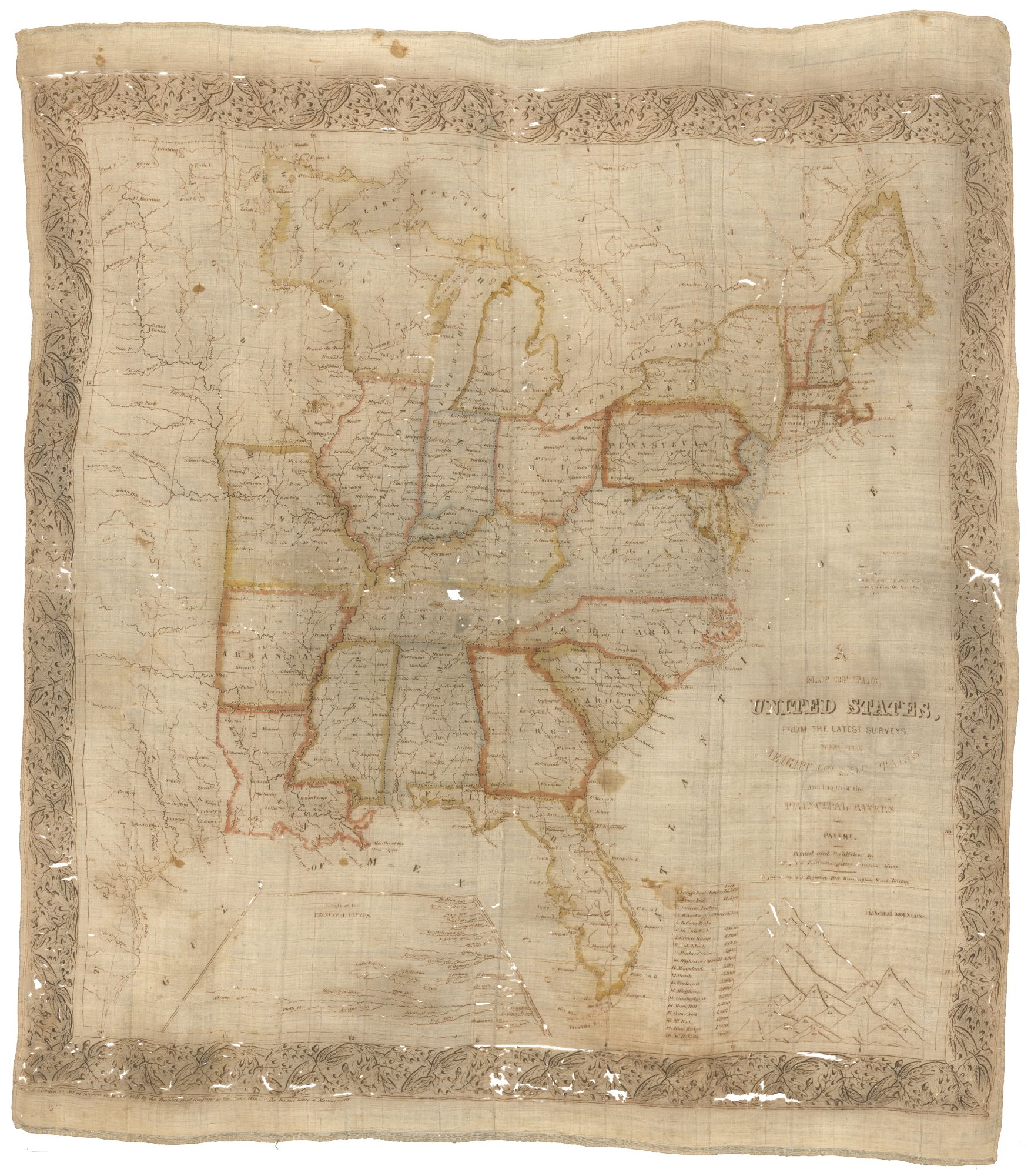
United States/ Cartographic Curiosity. BOYNTON, George W. (engraver)/ TUTTLE, Joseph Willard (publisher) [Boston: Tremont Print Company: dated 1841] A MAP OF THE UNITED STATES, FROM THE LATEST SURVEYS. WITH THE HEIGHT OF MOUNTAINS And length of the PRINCIPAL RIVERS. PATENT. 25 3/4 x 25 inches (image not including margins). Lithographed map in sepia ink with original outline & light wash color on polished linen. Toned with a few stains as expected; several small areas of missing cloth, several place names obscured in West Virginia and Tennessee & some as well in title and imprint; fair to good condition overall. A very rare and decorative map of the United States printed on cloth, one of only a few textile-printed maps to appear in the United States prior to 1900. In Threads of History, a quite comprehensive work on textile printing of Americana, this was one of only four early American maps thus printed. The map itself is, geographically speaking, of surprisingly high quality for work intended as a piece of ornamental clothing. It extends far enough west to include the eastern part of the then Republic of Texas and shows Houston only four years after its founding. Arkansas, admitted in 1836, is shown as a state, as are Missouri and Louisiana. It is not clear what the prototype was for this map, though it does bear some resemblance to Tanner’s 1829 map of the United States. Below the map, two interesting diagrams depict the lengths and heights respectively of the nation’s major rivers and mountains. In the 19th century such items were referred to, sometimes interchangeably, as bandannas, kerchiefs and handkerchiefs. Although printing on textiles began to appear in the United States in late 18th century, it did not flourish until the latter half of 19th century. Most produced at this time were political in nature, often associated with presidential candidates. Advertisements of the period indicate that this item was sold as an elegant pocket handkerchief that doubled as a handy geographic reference. The following appeared in the Boston Daily Atlas for May 25, 1841, page 2: We found upon our table yesterday an entire new article for pocket handkerchiefs, an exact and accurate copy of the map of the United States, printed in permanent color upon white silk. It makes a neat and splendid handkerchief, and must be at the same time exceedingly useful and convenient for reference, the color being entirely fast. It is printed and published by Joseph W. Tuttle, and was engraved by Mr Geo. W. Boynton, who is entitled to great credit for the taste and skill displayed in the work. The goods are for sale by the package or piece, by William G. Eaton, 36 Kilby street.” Joseph Willard Tuttle was a Boston map engraver and publisher active in the second quarter of the 19th century, though Stauffer’s American Engravers mentions him only in the context of the partnership of Morse & Tuttle, established in the 1830s. That partnership must have been dissolved by 1841, when this map was issued. Boston Daily Atlas for May 25, 1841, page, 2. George W. Boynton was a prominent map engraver and publisher during the same period, who produced a number of maps of Boston; see Mapping Boston, pp. 198-199. He also revised globes published by Loring and Joslin. Rumsey no. 2955 (sepia but uncolored); Threads of History, #152 (linen) & #153 (silk).
Sold