
click here to zoom
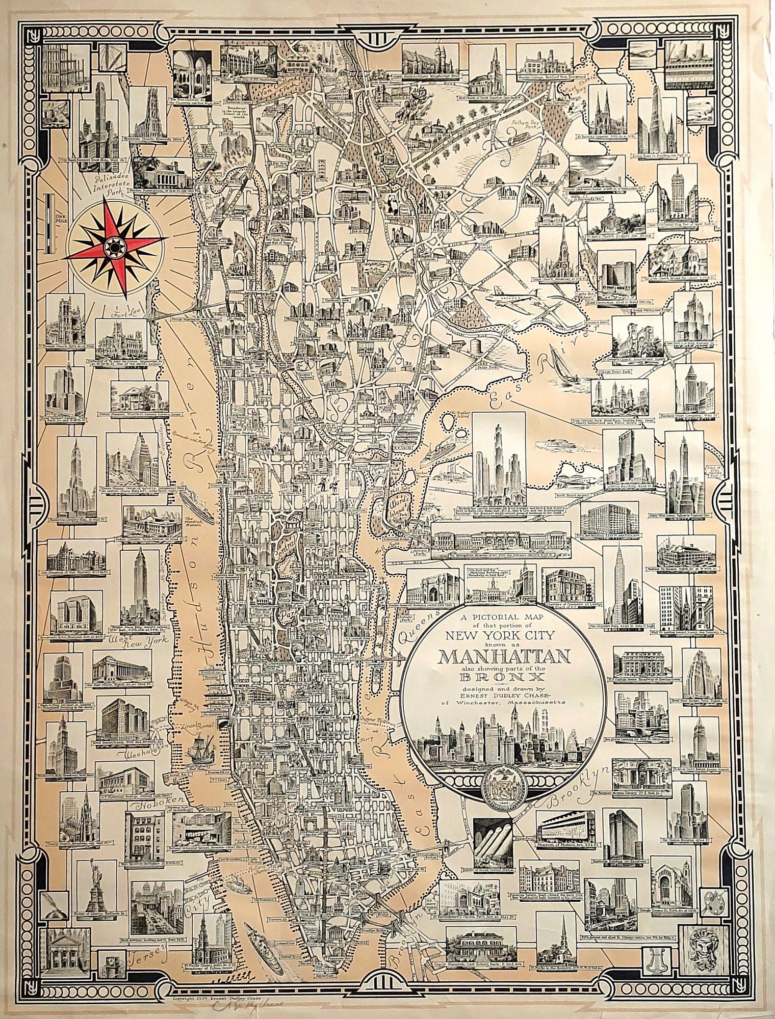
New York City. CHASE, Ernest Dudley [Winchester, MA: dated 1939] A Pictorial Map of that portion of New York City known as Manhattan also showing parts of the Bronx . . . 20 ½ x 27 ½ inches. Artist's signature in pencil lower left below copyright. Some chipping & mended splits in outer margin not affecting printed surface, else excellent. An excellent, signed example of one of the finest works by the great pictorial map artist, whose “maps were among the most ambitious of all American pictorial maps, …Chase was a skillful designer and meticulous mapmaker whose works retain great appeal” (Hornsby, pp. 31-32). A photo portrait of Chase’s warmly smiling visage is aptly captioned: “The man who turns the prose of maps into the poetry of art (Hornsby, p. 33). Chase spent six months to a year on each of his maps, and the nearly 100 finely detailed vignettes of New York City buildings and other scenes testify to his meticulous craftsmanship. Chase used a magnifying glass in his process, working "dot by dot, with tiny pens" in a pointillist style. In addition to the work’s numerous illustrations of buildings, it contains unexpected images, such as of the entrance to the Holland Tunnel and a view of Park Avenue looking north toward Grand Central Station. An exceptional aspect of this work is that provides an equally rich depiction of the major structures of the Bronx as it does for Manhattan. These include vignettes of several public and parochial schools. An attractive Art Deco border frames the map. Ernest Dudley Chase (1878-1966) was also one of the most prolific pictorial map artists of the 20th century, producing about 50 maps published from the 1930s to the 1960s, covering a wide assortment of places and topics. Born in Lowell, Massachusetts, he began his career as a graphic artist, establishing his own greeting card company, which he sold to Rust Craft Publishers in 1920. He authored The Romance of Greeting Cards, the first complete history of the medium, published in 1926, with a revised edition in 1956. It wasn’t until he was 49 years old did Chase began drawing maps, which he self-published from his home in Winchester, Massachusetts. Chase donated many examples of his maps to the Harvard University Map Collection, Pusey Library, which featured them in the exhibition "The Pictorial Maps of Ernest Dudley Chase" from February to April 2003. According to the curators of the exhibit, Chase "designed pictorial maps ranging in scale from his own hometown to global themes of navigation, exploration, communication, and world peace. He could be alternately whimsical, didactic, and subtly allusive--often on the same map." In 2009, the State Library of Massachusetts presented the exhibition "Ernest Dudley Chase: A Worldview in Maps," showcasing the wide variety of his works. Hornsby, S. Picturing America, pp. 31-31; “Ernest Dudley Chase.” National Cyclopedia of American Biography. James T. White & Co., after 1966; “Ernest Dudley Chase: A Worldview in Maps: Exhibit now on view at the State Library.” 22 May 2009; State Library of Massachusetts. Blog. http://mastatelibrary.blogspot.com/2009/05/ernest-dudley
Sold