click here to zoom
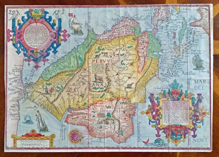
South America/ Southeast U.S./ Gulf of Mexico. LINSCHOTEN, J. VAN [Amsterdam, 1596/ ?] Delineatio omnium orarum totius Australis partis Americae, . . . 15 x 20 1/4 inches. Fine, possibly early hand color; right margin with some expert reinstatement of engraved border, very good. Arguably the most beautiful early map of South America (and part of North America) in a richly colored example. It displays the area at the approximate high water mark of the Spanish Empire in the New World. It was the only map of the Americas in Linschoten’s Itinerarium, the work that is credited with enabling the Dutch entry into the lucrative East Indies and Brazilian trade, once the exclusive preserves of the Portuguese. This ornately engraved work adopted the style of the Portuguese portolan chart on which it was based. Its vignettes illustrate many of the legends associated with South America, such as the giants of Patagonia. It was in Goa while employed as the secretary to the Portuguese archbishop from 1583 to 1589 that Linschoten acquired most of the information that was the basis of his maps and plans. Also valuable were the sailing guides he obtained that not only provided the best sailing routes to the East Indies and its lucrative spice trade but also showed the way from port to port once there. Upon his return to the Netherlands, Linschoten published these documents with accompanying maps along with his own lively descriptions of the area in the momentously important work, the Itinerario. Few books have had greater influence on historical events; this work literally “broke the Portuguese monopoly on the East Indian trade” (Walter) and helped usher in the Dutch Golden Age of unprecedented prosperity. Tooley et al, Landmarks of Mapmaking, pp. 216-220 (folding plate).
Sold