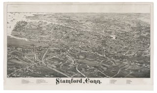
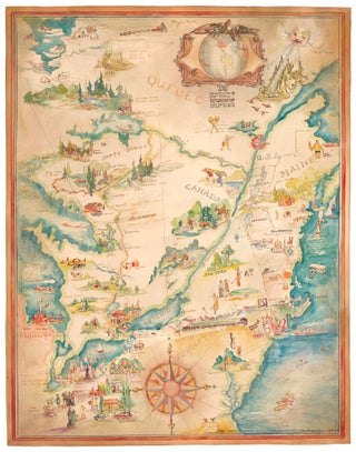
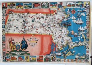
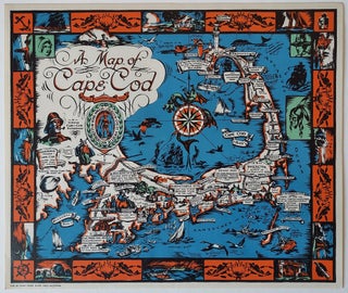
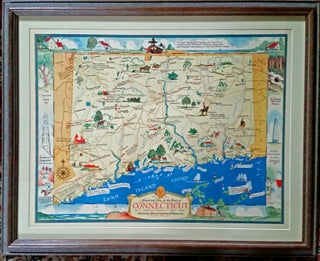
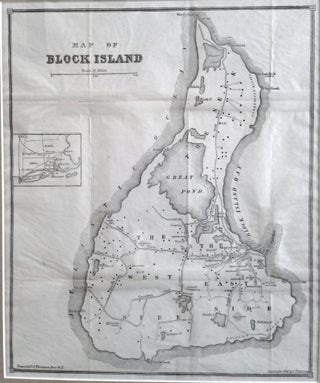
New England & New York
Out of stock
Stamford, Conn. BURLEIGH, L. R./ BECK & PAULI LITH. [Troy, NY & Milwaukee, WI: 1883] Stamford, Conn. 19 x 34 inches. Lithograph. Reinforced with rice paper, lower margin extended but no loss of printed surface, closed 7-inch split at left center & marginal splits, a few filled wormholes in printed.....
Board Game/ Newport/ Block Island. MCLOUGHLIN BROTHERS [New York: 1891] The Newport Yacht Race - An Exciting Game. Game board: 10 x19 ½ inches. Overall framed size: 29 1/4 x 23 1/4 x 1 3/4 inches. Multi-stone Lithography. Complete with cover, two sailboat game pieces, a spinning dial & instructions.....
Gentlemen's Driving Map Showing The Park System Of Boston…First Edition.
A rare map (not appearing in map market records) made of the "Gentleman" bicyclist, highlighting the not particularly ample park areas of Boston at the time. Noted with cautionary red lines are roads with street car tracks, presumably to be avoided by cyclists. Slanted green lines indicate unfinished roads. Bicycling.....
Railway And Highway Map of the Famous Berkshire Hills Region, Showing Villages And Also Points Of Interest;….
Large, attractive map of the lovely highlands of Berkshire County, one of the premier cultural-recreational destinations in the United States. Issued as a promotional instrument for the Berkshire Life Insurance Co., the map dates from the early days of the area as a recreational area. The map notes the mountain.....
New England/ Business & Real Estate History. CALHOUN PRINT CO. (publisher) [Hartford, CT: n.d. c. 1900] BUY HOMES OF J.W. WILBUR CO. 26 ¼ x 39 inches. Color-printed wood engraving. A few edge splits, printer’s crease at upper left, overall excellent condition. A large, vibrant broadside, produced for the visionary.....
Cape Cod. MURPHY, John F./ FEDERAL ENG. & PUB. CO. [Boston: dated 1905] Untitled view/ map of Cape Cod. 17 x 26 ¾ inches. Colored lithograph. Folding view, flattened; without covers; very slight fold wear, else a fine example. A rare, sweeping, aerial view emphasizing Cape Cod’s striking hook-like shape.....
Geo. W. Eldridge’s Chart C Vineyard Sound Lt-Ship to Chatham.
An uncommonly fine example of this scarce, well-detailed yet highly legible, nautical chart of the challenging waters in the area of Martha’s Vineyard and Nantucket. It is rich with navigational detail vital to anyone plying these problematic seas, all of which is presented with Eldridge’s characteristic clarity. In addition to.....
Nantucket/ Martha’s Vineyard/ Cape Cod. ELDRIDGE, George [Boston: 1914/ 1915 (stamped)] Geo. W. Eldridge’s Chart C Vineyard Sound Light-Ship to Chatham. 27 ¼ x 47 ½ inches. Lithograph mounted on original linen as originally issued, with identifying label & price list of available charts by Eldridge pasted on back; minor.....
Pictorial Map/ United States/ Canada. CASS, Katherine "Kae" Dorn [Cleveland, Ohio: 1928] Untitled Manuscript of the Northeast & Midwest U. S. & Part of Canada. 26 ¾ x 21 inches. Watercolor & ink on poster board; excellent condition. Highly animated and well-executed biographical map chronicling the travels, activities, adventures and.....
Massachusetts/ Education. SHURTLEFF, Elizabeth [New York: dated 1930] Map of Massachusetts The Old Bay State. [Secondary title:] A Picture History Map Published by the Graphic History Association… 26 ¼ x 38 inches. Four-color print. Two mended splits in margins, pin holes in corners, else excellent condition with very vibrant color. .....