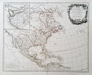
Canada & Arctic
Out of stock
A New Chart of the World On Mercator's Projection With The Track Of The Most Celebrated & Recent Navigators.
A beautiful example in full, vibrant, period color of a majestic, folding world map. A rare issue with very important updates. The map is an extraordinary compendium of oceanic exploration and contains voyage tracks from the 15th century to those contemporaneous with the map including those relating to polar and.....
A New Map For Travelers Through The United States Of America Showing The Railroads, Canals & Stage Roads.
A delicately beautiful map of mid-19th century United States with extensive transportation-related content. Four of the work’s five inset maps focus on rail lines and canals in specific parts of the country. The large inset of the western United States at bottom right completes the picture of the country that.....
Northeast/ Canada/ Transportation History. SMITH, J. Calvin [New York: 1855/ 1858] Smith’s Rail Road, Steam Boat & Stage Route Map Of New England, New-York And Canada. By J. Calvin Smith. Published by J. Calvin Smith71 Nassau St. N.Y. MDCCCLVIII. 22 X 26 ¾ inches. Folding map, here flattened & mounted.....
Washington State/ Mining History. RAND, MCNALLY & CO. [Chicago: 1890] Rand, McNally & Co.’s Sectional Map Of Washington. Scale, Eight Miles to One Inch. The Map Includes The Coeur d’Alene Mining District In Idaho… 37 1/4 x 55 3/4 inches. Lithograph with original hand color. Ex-folding map that has been.....
Pictorial Map/ United States/ Canada. CASS, Katherine "Kae" Dorn [Cleveland, Ohio: 1928] Untitled Manuscript of the Northeast & Midwest U. S. & Part of Canada. 26 ¾ x 21 inches. Watercolor & ink on poster board; excellent condition. Highly animated and well-executed biographical map chronicling the travels, activities, adventures and.....