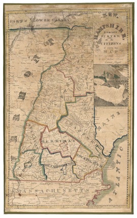
New Hampshire. RUGGLES, Edward/ EDDY, O. T. [Walpole, NH: 1817] NEW-HAMPSHIRE, From Late SURVEY; TO THE CITIZENS of which this MAP is most respectfully Dedicated by their obedient Servant Edward Ruggles. Engraving with outline color, refreshed, on two joined sheet: 29 x 18 ½ inches. Expertly conserved & fully stabilized.....
Americas
Out of stock
United States/Early Geographic Education/ Native American History. DAWES Jr., Samuel [Mississippi?: Dated: 1820] A Map of the United. States By Samuel Dawes Jr. 1820. [Verso:] Asia. 18 ¾ x 23 3/8 inches. Pen & ink & watercolor on woven paper. Some staining and age toning, three neatly closed splits into.....
Map of Portland Harbor, Maine.
Early, detailed plan of Portland Harbor, produced to accompany a report to the 23rd Congress with regard to a proposed breakwater for the harbor. The survey was executed by Lt. Col. John Anderson at the instruction of the Secretary of War Lewis Cass; the chart itself was drawn by Lt.....
Antigua/ Slave Emancipation. STOBWASSER, L./ HURLIMANN [Basel, 1835] Vue de Gracehill dans I’Isle d’Antigoa aux Indes occidentales. 8 ¾ x 11 1/8 inches. Aquatint with fine original color; slight mended edge split, few spots, else excellent. Rare, luminously colored view that relates directly to the then recent emancipation of slaves.....
DAGGETT & ELY (engravers)/ HUNTINGTON, E. (publisher) [Hartford: 1837] Map Of Connecticut from actual Survey…1837. 18 ¼ x 21 ¾ inches. Engraved map with vibrant, original hand color; excellent condition. Rare. The first known, printed map on which the town of Westport and its boundary lines appear. The town was.....
A New Chart of the World On Mercator's Projection With The Track Of The Most Celebrated & Recent Navigators.
A beautiful example in full, vibrant, period color of a majestic, folding world map. A rare issue with very important updates. The map is an extraordinary compendium of oceanic exploration and contains voyage tracks from the 15th century to those contemporaneous with the map including those relating to polar and.....
United States/ Cartographic Curiosity. BOYNTON, George W. (engraver)/ TUTTLE, Joseph Willard (publisher) [Boston: Tremont Print Company: dated 1841] A MAP OF THE UNITED STATES, FROM THE LATEST SURVEYS. WITH THE HEIGHT OF MOUNTAINS And length of the PRINCIPAL RIVERS. PATENT. 25 3/4 x 25 inches (image not including margins). Lithographed map.....
MCBRIDE, James (Mapmaker)/ KLAUPRECH & MENZEL (Lithographers)/ CAMERON, James B. (Publisher) [Cincinnati: c. 1839-1844] Map Of The Towns Of Hamilton And Rossville… 26 x 33 ¾ inches. Lithograph. Expertly conserved involving some loss of image reinstated in facsimile, particularly at top; margins almost entirely reinstated. Lingering toning and staining, again.....
The Cerographic Missionary Atlas… [Imprint inside front cover:] Entered according to Act of Congress, in the year 1848, By Se. E. Morse & Co.,….
An unusually well-preserved, scarce, and quite early American atlas of areas where missionary activity was being, or could be conducted. Includes an excellent map exclusively of the Hawaiian Islands. A map entitled “Indian Territory” encompasses Texas and east from Lake Superior and the Mississippi River to the Rocky Mountains in.....
A New Map For Travelers Through The United States Of America Showing The Railroads, Canals & Stage Roads.
A delicately beautiful map of mid-19th century United States with extensive transportation-related content. Four of the work’s five inset maps focus on rail lines and canals in specific parts of the country. The large inset of the western United States at bottom right completes the picture of the country that.....
Map of the Towns of Saybrook and Old Saybrook Middlesex County Connecticut.
A beautifully preserved wall map, in very attractive, period wash coloring, of the lower Connecticut towns of Old Saybrook, Essex, Deep River, Centerbrook and Ivoryton, located at or near the mouth of the Connecticut River on the eastern side. The overall map is complemented with plans of the central areas.....
Nautical Chart: Block Island to Cuba. BLUNT, E. & G. W./ COPLEY, Charles [New York, 1853] Coast Of North America from Point Judith to Cape St. Antonio. (Island Of Cuba) Including The Bhama Banks… Every Authentic Survey, American, English & Spanish, Has Been Used In The Construction Of This Chart… 29.....
NIC. MULLER (Printer)/ NICHOLS, David (Engraver) [New York: dated October 1854] BUSSINES (sic) DIRECTORY OF WESTPORT. 20 ½ X 25 ½ inches. Two-stone lithograph (red and blue) mounted on heavy card stock. Two mended 4-inch splits at right and left, a few other mended splits entering printed surface, some edge.....
GREELEY, Horace/ FARWELL, Leonard J. [Madison?: n.d. but 1856] Map of Madison and the Four Lake Country, Dane Co. Wis. 16 ¾ x 26 ¼ inches. Ceragraphic (wax-engraved) map on thin paper. Lightly toned, some fold reinforcements, restored losses at two fold intersections and to outer margins; still good condition for.....
Northeast/ Canada/ Transportation History. SMITH, J. Calvin [New York: 1855/ 1858] Smith’s Rail Road, Steam Boat & Stage Route Map Of New England, New-York And Canada. By J. Calvin Smith. Published by J. Calvin Smith71 Nassau St. N.Y. MDCCCLVIII. 22 X 26 ¾ inches. Folding map, here flattened & mounted.....
N. America West Coast San Francisco HarbourSurveyed by Lieut. James Alden U. S Navy 1856.
A superb, scarce, very well-preserved, mid-19th century chart of San Francisco Bay and Harbor. Although a semi-official British chart, it was based on the survey of an American Naval officer, Lt. James Alden. Under the superintendence of Capt. Washington, the Admiralty office greatly increased its output and obtained surveys sources.....
Large, Untitled Chart of Long Island Sound, the Connecticut Shoreline, New York City & Vicinity, All of Long Island. [With three large, titled inset charts:] Chart Of Massachusetts Bay…/ Chart Of The East River Entrance To New York … / Hell Gate, And Its Approaches….
Rare. This was as authoritative a chart of these waters as was available at the time. Despite its density of detail, the chart was engraved with uncommon clarity. Its delineation of the Connecticut shoreline includes the many, small harbor islands, especially along the western shore. Also, all inlets, rivers and.....
Battle of Gettysburg. DITTERLINE, T. [New York, 1864] Sketch of the Battles of Gettysburg…Compiled From The Personal Observation Of Eye-Witnesses Of The Several Battles… [Map:] Field Of Gettysburg …Prepared By T. Ditterline. Octavo in original, blue, whorled, silked paper wrappers, 24pp; now separate; chromolithographed, folding map with troop position in.....
Manhattan. VIELE, Egbert L. [New York, 1865] Topographical Map of the City of New York,… 18 x 62 ½ inches. Lithograph with original hand color; flattened & mounted on rice paper, light discoloration & a few reinforcements at some folds, else excellent. With pamphlet (13 pp) describing the map and.....