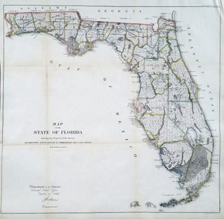
Florida. GENERAL LAND OFFICE [Washington, DC: Oct. 2, 1866] Map Of The State Of Florida Showing the Progress of the Surveys… 23 x 24 ¼ inches. Lithograph with outline hand color; slight losses at fold intersections, back with rice paper for stability, overall an excellent, bright example. Large, attractive.....
Americas
Out of stock
Field Of Gettysburg …Prepared By T. Ditterline.
This striking, oval-shaped plan provided the American public with its first detailed and accurate visual account of one of the most significant battles in American history. It is accompanied by a pamphlet that provides an in-depth, chronological account of the complex battle. Offered here is the very rare second edition.....
Burritt's Sectional and Township Map of Minnesota Compiled from the latest authentic sources by J.B. Power, Chief Draughtsman Sur. Genl. Office, St. Paul, Minn. 1870. .
Scarce. A large, richly detailed map of the state of Minnesota, revealing the dramatic expansion of railway connections from the Great Lakes into the West. First printed in 1870, the map was quickly updated with this 1871 edition in order to keep up with the rapid changes taking place in.....
Minneapolis, MINN.
Rare and in superb condition. The second printed view of the Minneapolis, which was preceded only by Hageboeck view of 1873 and a view of both St. Anthony and Minneapolis in 1867, the year of the latter city obtained its charter. This is the larger, separately-published version of the view.....
Nantucket/ Martha’s Vineyard/ Cape Cod. ELDRIDGE, G. [Boston, 1857/ 1874] Chart of the Vineyard Sound and Nantucket Shoals… 40 ½ x 62 ½ inches. Lighthouses and other navigational aid highlighted in color; expertly conserved & re-mounted on new linen, margins extended, some relatively light staining, early notations in pencil, still.....
Camp Apache, Arizona.
An important, wonderfully detailed, signed and dated watercolor view of arguably the most storied western American fort, here called Camp Apache, later becoming Fort Apache. The fort was located near present-day Whiteriver in the central eastern part of Arizona. It was at the flashpoint of the decades-long Apache Wars and.....
California & Western States/ Pacific Northwest/ Railroad History. WATSON, Gaylord [New York, 1876] Watson’s New County and Railroad Map of the Pacific States… 38 x 25 inches. Lithographed folding map with period hand color; extracted from original covers, retained, flattened & expertly mounted on rice paper; few splits & some.....
State of California. Published by the Department of the Interior, General Land Office. J. A. Williamson, Commissioner.
Attractive, richly detailed map, important for the extent of railroad information that includes even small spur lines and stations. Also significant is the table listing 545 private land grants that are keyed to the map. Using the best available sources, the map was compiled from the official records of the.....
State of Nevada. Published by the Department of the Interior, General Land Office. J. A. Williamson, Commissioner.
An excellent map of the state compiled from the official records of the General Land Office and other sources by C. Roeser, Principal Draughtsman of the G.L.O. Mining operations and mountain ranges are shown in considerable details. It also shows rail lines, range and township lines, cities and towns, county.....
Nantucket/ Baseball History. STONER, J. J./ BECK & PAULI [Madison, WI, 1881] Bird’s Eye View of the Town of Nantucket in the State of Massachusetts. Looking Southwest.1881. 19 ¼ x 27 3/8 inches. Two-stone lithograph. Mounted on acid-free paper, invisible mends in margin and of one split entering the printed.....
Stamford, Conn. BURLEIGH, L. R./ BECK & PAULI LITH. [Troy, NY & Milwaukee, WI: 1883] Stamford, Conn. 19 x 34 inches. Lithograph. Reinforced with rice paper, lower margin extended but no loss of printed surface, closed 7-inch split at left center & marginal splits, a few filled wormholes in printed.....
Washington Territory. J. K. GILL & CO./ GALVANI, W. H. [Portland, OR: 1884] J. K. Gill & Cos. Map of Washington. Portland Ogn. 1884./ New Sectional, Township & County Map of Washington…1884. 22 ½ x 27 inches. Lithograph with full, original wash color. Ex-folding map, here flattened, original embossed covers.....
Bermuda. U. S. NAVY HYDROGRAPHIC OFFICE [Washington, DC: March 1878/ June 1887] North Atlantic Ocean. Bermuda Islands. From The Most Recent Brit. Admty. Surveys. 1877. 28 x 38 ¼ inches. Lithograph with three insets printed on separate sheets & pasted on. Lighthouses denoted with hand color. Expertly mounted on new.....
OREGON IMMIGRATION BOARD. Portland Oregon and Its Surroundings, 1889. Issued by the Oregon Immigration Board. Portland, Oregon: Oregon Immigration Board, 1889. Lewis & Dryden Print Co. Lith. Lithograph. 12 x 19.1/4 inches plus margins. Lightly toned, short mended fold split, two pin holes in centerfold, else excellent. .....
Washington State/ Mining History. RAND, MCNALLY & CO. [Chicago: 1890] Rand, McNally & Co.’s Sectional Map Of Washington. Scale, Eight Miles to One Inch. The Map Includes The Coeur d’Alene Mining District In Idaho… 37 1/4 x 55 3/4 inches. Lithograph with original hand color. Ex-folding map that has been.....
Board Game/ Newport/ Block Island. MCLOUGHLIN BROTHERS [New York: 1891] The Newport Yacht Race - An Exciting Game. Game board: 10 x19 ½ inches. Overall framed size: 29 1/4 x 23 1/4 x 1 3/4 inches. Multi-stone Lithography. Complete with cover, two sailboat game pieces, a spinning dial & instructions.....
Gentlemen's Driving Map Showing The Park System Of Boston…First Edition.
A rare map (not appearing in map market records) made of the "Gentleman" bicyclist, highlighting the not particularly ample park areas of Boston at the time. Noted with cautionary red lines are roads with street car tracks, presumably to be avoided by cyclists. Slanted green lines indicate unfinished roads. Bicycling.....
Panoramic Views along the Line of the Denver & Rio Grande Railroad. The Scenic Line Of The World.
A superbly realized promotional brochure, one of the finest we've seen, issued by the Denver & Rio Grande Railroad, featuring a sequence of nine beautiful views of Colorado's mountainous natural wonders, many with trains cutting through the landscape. Fittingly the railroad's original motto was "Through the Rockies, not around them.".....
Railway And Highway Map of the Famous Berkshire Hills Region, Showing Villages And Also Points Of Interest;….
Large, attractive map of the lovely highlands of Berkshire County, one of the premier cultural-recreational destinations in the United States. Issued as a promotional instrument for the Berkshire Life Insurance Co., the map dates from the early days of the area as a recreational area. The map notes the mountain.....
New England/ Business & Real Estate History. CALHOUN PRINT CO. (publisher) [Hartford, CT: n.d. c. 1900] BUY HOMES OF J.W. WILBUR CO. 26 ¼ x 39 inches. Color-printed wood engraving. A few edge splits, printer’s crease at upper left, overall excellent condition. A large, vibrant broadside, produced for the visionary.....
Maui. ALEXANDER, W. D./ DODGE, F. S. [Washington, DC: 1885/ 1903] Hawaiian Government Survey. W. D. Alexsander Surveyor-General. Maui Hawaiian Islands… 43 ¼ x 54 inches. Lithograph with bright water colors. Folding map here expertly flattened and mounted on acid-free paper and linen; a few minor mends at folds else.....