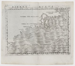
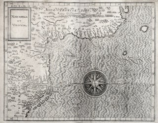
Northeast-Southeast/ New York City/ Bermuda. GASTALDI, G. [Venice, 1548] Tierra Nueva. 5 1/4 x 6 3/4 inches. A fine example with an uncommonly strong impression. .....
Northeast-Southeast/ New York City/ Bermuda. GASTALDI, G. [Venice, 1548] Tierra Nueva. 5 1/4 x 6 3/4 inches. A fine example with an uncommonly strong impression. .....
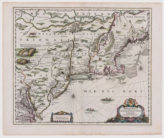
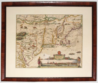
Northeast/ New York City. JANSSON, J. [Amsterdam, 1651] Belgii Novi, Angliae Novae, Et Partis Virginiae Novissima Delineatio. 17 ¼ x 20 ¼ inches. Superb original color; a few vertical creases else excellent with wide margins. .....
![Item #11075 FIRST VIEW of the BATTLE of PATAPSCO NECK [:] DEDICATED TO THOSE WHO LOST THEIR...](https://rtamaps.cdn.bibliopolis.com/pictures/11075.jpg?width=320&height=427&fit=bounds&auto=webp&v=1585677032)
Extremely rare, unrecorded proof (or first) state, by an American participant, of the September 1814 Battle of North Point, at which Maryland militia stoutly defended Baltimore against a large force of British regulars.The early land campaigns of the War of 1812 took place along the Canadian border, but in mid.....
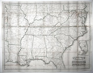
Large, detailed, up-to-date map of the entire theatre of the American Civil War, accompanied by a booklet that provides a day to day history of the war from its beginning to November 30th, 1863. Red circles on the map indicate the sites of engagements. Railroad lines are shown throughout, and.....
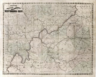
Very scarce, richly informative map showing the oil, gas and coal discoveries in West Virginia at the beginning of that region’s oil boom. The key areas along the Little Kanawha and Hughes Rivers in West Virginia and on Buck Creek in Ohio are shown in great detail. Roads, railroads and.....
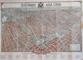
A very scarce and precise "Aero View" of Washington, DC, as seen from the southeast, self described, not entirely without justification, as "the most remarkable picture map that has ever been made." With a 48-page travel guide to the city illustrating its notable attractions. Referring to a larger version of.....
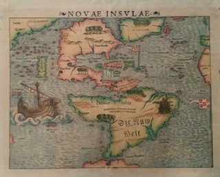
Americas. MUNSTER, Sebastian. [Basle: 1540 [c. 1544-50]] Novae Insulae. 10 ½ x 13 ½ inches. Fine early color; some age toning, a few marginal stains, else excellent. The earliest collectible map of the Western Hemisphere.....
This very early map reveals the state of geographic knowledge of the Northeast and Mid-Atlantic regions at the time of their initial colonization. "A superbly executed engraving, [the map] depicts the northeastern American coastline as it was perceived by European geographers one hundred years after the discovery of the New World.....
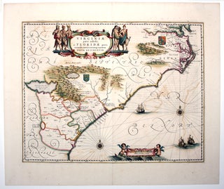
A map that combines elegant design with historical importance, it depicts the area from the lower Chesapeake Bay, down through North Carolina’s Outer Banks, the entire coastlines of South Carolina and Georgia, along through to northern Florida. The map reflects the growth of the English colony beyond the Jamestown settlement.....
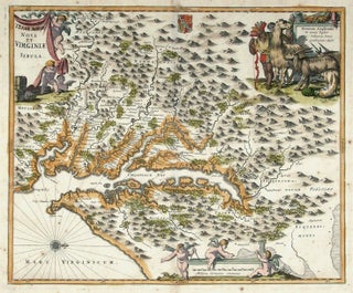
Virginia/ Maryland. OGILBY, J./ MONTANUS, A. [Amsterdam: 1671] [Terrae- Mariae] Nova [et] Virginiae Tabula. 11 3/8 x 13 7/8 inches. Fine hand color; old manuscript additions to title; lightly age-toned, else excellent condition. .....
This is the most lavishly decorative of all the early editions of the best 17th century, Dutch map of the Northeast and New York. It added illustrations of animals and other detail not found on previous issues. The map was the culmination of all the surveys of the area conducted.....
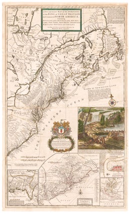
North America/ Postal History/ Carolinas. MOLL, H. [London, 1715/ 1731] A New and Exact Map of the Dominions of the King of Great Britain on ye Continent of North America. ... By Herman Moll Geographer. ... 39 5/8 x 23 7/8 inches. Full original color; lightly toned, some folds reinforced.....
Northeast/ Mid Atlantic/ Old Northwest. ROBERT DE VAUGONDY, Didier. [Paris, 1755] Amerique Septentrionale, dressee, sur les Relations les plus modernes des Voyageurs et Navigateurs 18 ¾ x 22 ¾ inches. Original outline color; excellent condition. First state of a well-detailed map of a soon-to-be contested part.....
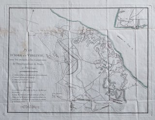
Attractive map showing the English, French and American positions at the Battle of Yorktown with French and American units named. Washington’s headquarters, as well as those of the French commanders, are shown. From F. Soules’ Histoire des troubles de l’Amerique Anglaise.
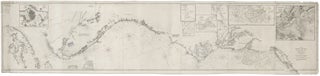
Nautical Chart: Block Island to Cuba. BLUNT, E. & G. W./ COPLEY, Charles [New York, 1853] Coast Of North America from Point Judith to Cape St. Antonio. (Island Of Cuba) Including The Bhama Banks… Every Authentic Survey, American, English & Spanish, Has Been Used In The Construction Of This Chart… 29.....
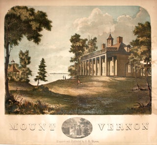
WELLS, C. H. (Artist)/ COLLINS, F. (Printer)/ BYRAM, J. H. (Publisher) [Philadelphia: 1859] Mount Vernon. 18 ¼ x 19 ¾ inches. Color-printed lithograph. Lightly toned, darker on back, two mended marginal splits, overall very good. .....