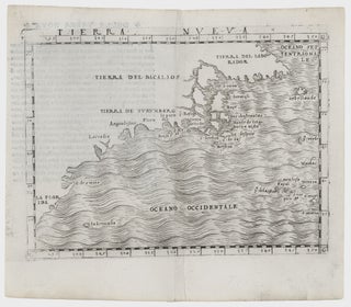
Northeast-Southeast/ New York City/ Bermuda. GASTALDI, G. [Venice, 1548] Tierra Nueva. 5 1/4 x 6 3/4 inches. A fine example with an uncommonly strong impression. .....
Northeast-Southeast/ New York City/ Bermuda. GASTALDI, G. [Venice, 1548] Tierra Nueva. 5 1/4 x 6 3/4 inches. A fine example with an uncommonly strong impression. .....
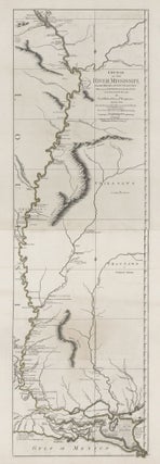
Tall, striking work based on the first official survey of the lower Mississippi River done in 1763. The map extends north to just below St. Louis. It provides considerable detail for the New Orleans area and shows Baton Rouge and Lake Pontchartrain. The map is significant for its delineation of.....
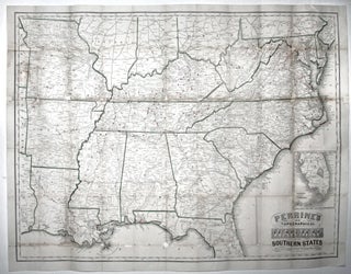
Large, detailed, up-to-date map of the entire theatre of the American Civil War, accompanied by a booklet that provides a day to day history of the war from its beginning to November 30th, 1863. Red circles on the map indicate the sites of engagements. Railroad lines are shown throughout, and.....
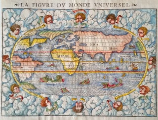
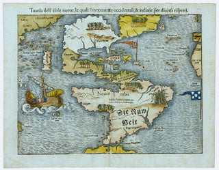
An excellent example of this early, woodcut world map, rich in the imagery of the Discovery Period with its many sea monsters and surrounding wind heads. The map provides an overview of the known world of the mid-16th century, just after the first great wave of New World discoveries. The.....
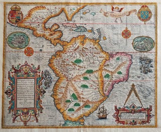
Excellent example of the earliest separate map of the entire Western Hemisphere. This was also the earliest map to refer to the Pacific Ocean (along with Munster's world map) by a variant of its present name, Mare pacificum. It was one of earliest acquirable maps to show Japan prominently, which.....
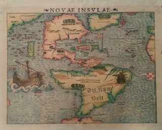
Americas. MUNSTER, Sebastian. [Basle: 1540 [c. 1544-50]] Novae Insulae. 10 ½ x 13 ½ inches. Fine early color; some age toning, a few marginal stains, else excellent. The earliest collectible map of the Western Hemisphere.....
Arguably the most beautifully engraved early map of the Caribbean, including Florida and the Southeast, here with color of uncommon beauty. The map includes representations of Columbus’ ships and various notes regarding his discoveries. It appeared in Book IV of De Bry’s Grands Voyages with text by Benzoni. De Bry’s.....
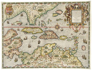
South America/ Southeast U.S./ Gulf of Mexico. LINSCHOTEN, J. VAN [Amsterdam, 1596/ ?] Delineatio omnium orarum totius Australis partis Americae, . . . 15 x 20 1/4 inches. Fine, possibly early hand color; right margin with some expert reinstatement of engraved border, very good. .....
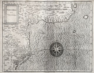
This very early map reveals the state of geographic knowledge of the Northeast and Mid-Atlantic regions at the time of their initial colonization. "A superbly executed engraving, [the map] depicts the northeastern American coastline as it was perceived by European geographers one hundred years after the discovery of the New World.....
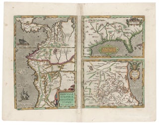
Southeast/ Florida/ Columbia/ Bolivia ORTELIUS, A./ CHIAVES, H. [Antwerp/ London, 1584/ 1606] La Florida. Auctore Hieron. Chiasues. Peruviae Auriferae Regionis Typus… Guastecan Reg. 14 x 18 inches. Fine original color; light staining along centerfold & a bit in the margins, else excellent condition. .....
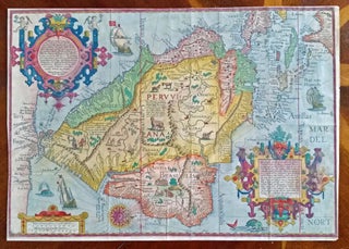
South America/ Brazil/ Caribbean/ Florida. DE BRY, T. [Frankfurt, 1592/ 1624] Americae Pars Magis Cognita. Chorographia nobilis & opulentae Peruanae Provinciae, atque Brasiliae, . . . MDCXXIV. 14 3/8 x 17 1/4 inches. Fine hand color; margins expertly extended with no loss of engraved surface, else excellent condition. .....
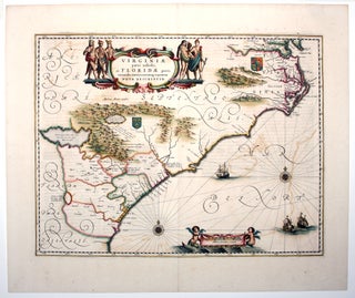
A map that combines elegant design with historical importance, it depicts the area from the lower Chesapeake Bay, down through North Carolina’s Outer Banks, the entire coastlines of South Carolina and Georgia, along through to northern Florida. The map reflects the growth of the English colony beyond the Jamestown settlement.....
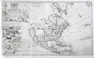
North America/ California as Island. MOLL, H. [London, 1720] To the Right Honourable John Lord Sommers . . . This Map of North America . . . 22 5/8 x 38 inches. Original outline color; few, small wormholes in upper margin, reinforcement in lower margin, else excellent condition. .....
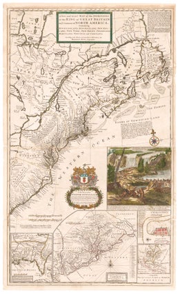
North America/ Postal History/ Carolinas. MOLL, H. [London, 1715/ 1731] A New and Exact Map of the Dominions of the King of Great Britain on ye Continent of North America. ... By Herman Moll Geographer. ... 39 5/8 x 23 7/8 inches. Full original color; lightly toned, some folds reinforced.....
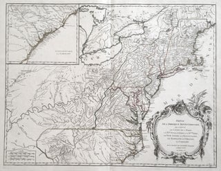
Northeast/ Mid Atlantic/ Old Northwest. ROBERT DE VAUGONDY, Didier. [Paris, 1755] Amerique Septentrionale, dressee, sur les Relations les plus modernes des Voyageurs et Navigateurs 18 ¾ x 22 ¾ inches. Original outline color; excellent condition. First state of a well-detailed map of a soon-to-be contested part.....
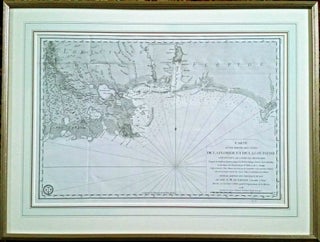
American Revolution/ New Orleans/ Baton Rouge/ Mobile Bay/ Pensacola. De SARTINE, Gabriel Carte [Paris: 1778 [1780]] D’une Partie Des Cotes De La Floride Et De La Louisiane. 15 3inches. Fine condition. In fine archival frame and French mat. .....
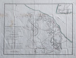
Attractive map showing the English, French and American positions at the Battle of Yorktown with French and American units named. Washington’s headquarters, as well as those of the French commanders, are shown. From F. Soules’ Histoire des troubles de l’Amerique Anglaise.
United States/ Cartographic Curiosity. BOYNTON, George W. (engraver)/ TUTTLE, Joseph Willard (publisher) [Boston: Tremont Print Company: dated 1841] A MAP OF THE UNITED STATES, FROM THE LATEST SURVEYS. WITH THE HEIGHT OF MOUNTAINS And length of the PRINCIPAL RIVERS. PATENT. 25 3/4 x 25 inches (image not including margins). Lithographed map.....
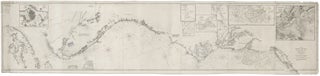
Nautical Chart: Block Island to Cuba. BLUNT, E. & G. W./ COPLEY, Charles [New York, 1853] Coast Of North America from Point Judith to Cape St. Antonio. (Island Of Cuba) Including The Bhama Banks… Every Authentic Survey, American, English & Spanish, Has Been Used In The Construction Of This Chart… 29.....
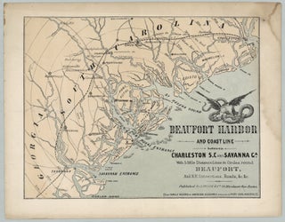
Beaufort, SC & Environs/ Civil War. L. PRANG & CO. [Boston: c. 1861] Beaufort Harbor and Coast Line Between Charleston S.C. and Savanna Ga. With 5 Mile Distance Lines in Circles round Beaufort, and R.R. Connections, Roads, &c. &c. 9 x 12 inches. Color Lithograph, 9” x 12”, plus margins.....
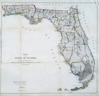
Florida. GENERAL LAND OFFICE [Washington, DC: Oct. 2, 1866] Map Of The State Of Florida Showing the Progress of the Surveys… 23 x 24 ¼ inches. Lithograph with outline hand color; slight losses at fold intersections, back with rice paper for stability, overall an excellent, bright example. Large, attractive.....
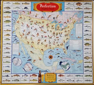
HORLACHER BREWING CO. [Allentown, Pennsylvania, 1946] Perfection Angler's Guide. 32 x 34 ½ inches. Color-printed. Excellent condition with vibrant color. A scarce, vibrant and informative promotional poster featuring two of mankind’s greatest pleasures—beer and.....