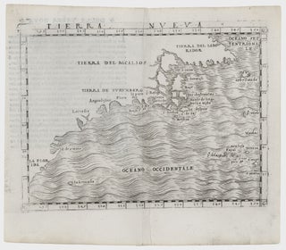
Northeast-Southeast/ New York City/ Bermuda. GASTALDI, G. [Venice, 1548] Tierra Nueva. 5 1/4 x 6 3/4 inches. A fine example with an uncommonly strong impression. .....
Northeast-Southeast/ New York City/ Bermuda. GASTALDI, G. [Venice, 1548] Tierra Nueva. 5 1/4 x 6 3/4 inches. A fine example with an uncommonly strong impression. .....
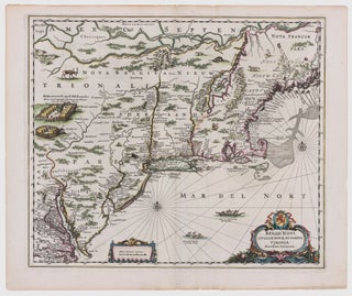
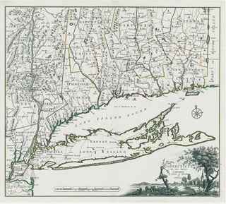
Northeast/ New York City. JANSSON, J. [Amsterdam, 1651] Belgii Novi, Angliae Novae, Et Partis Virginiae Novissima Delineatio. 17 ¼ x 20 ¼ inches. Superb original color; a few vertical creases else excellent with wide margins. .....
A map that is as historically important as it is attractive: it was the culmination of all the surveys conducted by the Dutch colonists of New Netherlands during their first three decades in America. It is also the first printed map to delineate the shape of Manhattan with relative accuracy;.....
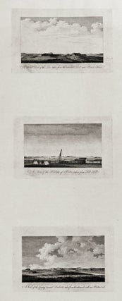
The complete set of six views (on two sheets), all relating to Boston; very rarely seen complete. These fine engravings of various vistas of Boston are important records of the area prior to as well as just after the beginning of the Revolution. Three of views show Boston itself, from.....
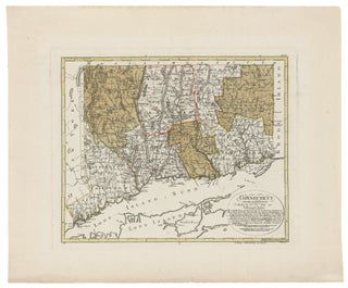
Connecticut. ROMANS, B./ COVENS & MORTIER & COVENS [Amsterdam, 1780] Connecticut and Parts adjacent… 20 ½ x 23 ¼ inches. Copperplate engraving with original outline color; all edges deckled, uncut; mint condition; in a fine archival frame. Very rare; separately published. The earliest acquirable map of Connecticut.....
Connecticut. SOTZMANN, D. F. [Hamburg: 1796] Connecticut entworfen van D. F. Sotzmann… 14 x 17 1/8 inches. Full original wash color; fine condition with very wide margins. Separately published. One of the most advanced and detailed maps of Connecticut to date. Sotzmann's.....
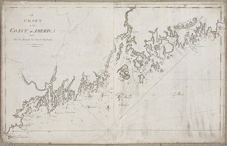
Maine/ Canada. NORMAN, John & William. [Boston, 1801/ 1803] A Chart of the Coast of America from Wood Island to Good Harbour From Hollands Surveys. 20 x 32 inches. Expected soiling & wear, some repairs to outer areas with small areas of restorations, still very good of this kind. The.....
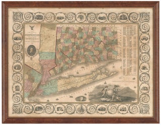
Connecticut. WARREN & GILLET/ GEORGE GILLET ESQ./ WILLARD, A. (PUBLISHER) [Hartford, 1847] Connecticut from the actual Surveys of Warren & Gillet With addition of new towns turnpike roads &C by George Gillet Esqr. 17 5/8 x 21 ¾ inches. Lithograph with original hand color, refreshed; expertly conserved & re-backed with.....
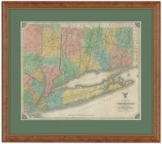
Connecticut. NEVERS, R./ DAMERUM, W. [Hartford, 1851] The State of Connecticut including Parts of New York and New Jersey. 23 x 28 ¼ inches (engraved area only. Original wash hand color, refreshed; re-mounted on new linen & expertly conserved; toned, some spotting, a few splits but overall very good. In.....
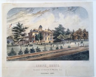
BONAR, Thomas [New York, c. 1855] Compo House. The Residence of Richard H. Winslow Esq. at Westport, Conn. 17 ¼ 21 ¼ inches. Color lithograph. Expertly mounted on acid-free paper; well-mended split lower right imperceptibly extending into printed surface, light mat burn, very good overall. .....
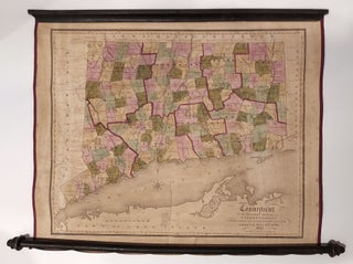
The State of Connecticut with all the new towns, including Parts of New York and New Jersey. 23 x 33 inches. Lithograph with original hand color, refreshed; wall map expertly conserved & re-mounted on new linen; relatively minor cracking, excellent of this type. Elegantly framed. .....
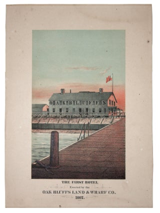
A superb chromolithograph, subtly capturing the burnishing effects of rosy dawn lighting, on Martha’s Vineyard first resort hotel. The plain, somewhat barn-like structure depicted here is in keeping with the middle-class nature of the Wesleyans who created the island’s first resort community. Other and grander hotels soon followed, resulting in.....
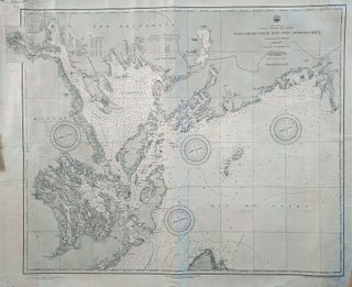
Maine/ Canada/ Passamaquoddy Bay/ Deer & Campobello Islands. HYDROGRAPHIC OFFICE, U. S. NAVY [Washington, D. C.: January, 1891] North America United States And Canada Passamaquoddy Bay And Approaches. 29 x 34 ½ inches. Lithograph with ighthouses daubed in yellow watercolor; some mended splits entering surface, partial reinforcing of outer margins.....
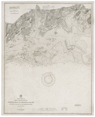
U.S. COAST & GEODETIC SURVEY. [Washington, DC: 1894/ 1898] North Shore Of Long Island Sound George’s Rock To Sheffield Island Including Saugatuck And Norwalk Rivers Connecticut… 42 x 33 ¼ inches. Lithograph expertly mounted on new linen. A few closed splits in margin & outer printed areas; overall very good.....
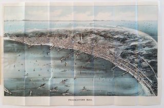
Provincetown, Massachusetts. Walker Lith. & Pub Co. ]Boston: 1910] Walker’s Bird’s_Eye View of Provincetown… 10 ½ x 16 ¾ inches. Two-stone, folding lithograph on banknote paper, in original heavy paper covers, with street plan on front cover. Light glue stain at left else an excellent example. In.....
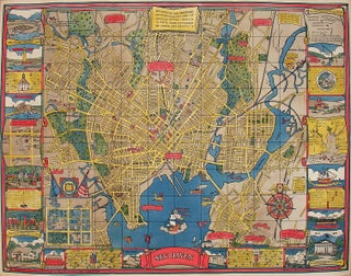
New Haven, Conn/ Yale University. MORTIMER (later MILLIGAN), Carina Eaglesfield/ EDWARD P. JUDD CO. (publisher) [New Haven: 1928] New Haven. 27 x 35 inches. Color printed; mounted on archival paper, very slight fold wear, else excellent. A vibrant, large plan of New Haven--a charming.....
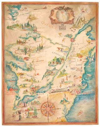
Pictorial Map/ United States/ Canada. CASS, Katherine "Kae" Dorn [Cleveland, Ohio: 1928] Untitled Manuscript of the Northeast & Midwest U. S. & Part of Canada. 26 ¾ x 21 inches. Watercolor & ink on poster board; excellent condition. Highly animated and well-executed biographical map chronicling the travels, activities, adventures and.....
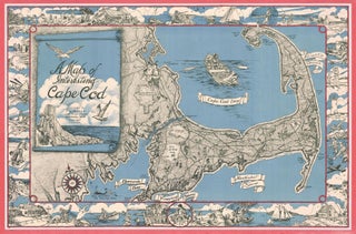
Cape Cod. MILLER, F. J. [Westwood, MA, c. 1945-1950] A Map of Interesting Cape Cod Plublished (sic) by F. J. Miller 1045 High Street Westwood, Mass. Copywright (sic) F. J. Miller Three-stone lithograph. 21 ¾ x 33 inches; with frame: 25 x 36 inches. Some fading of red border, else.....
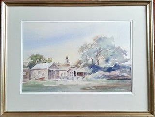
MORSE, Charles L. [Nantucket, 1987] Nantucket, South Beach. 13 ¾ x21 inches. Watercolor. Matted & in original frame. Fine condition. A skillful rendering of South Beach cottages in Nantucket as seen from the water, with the steeple.....
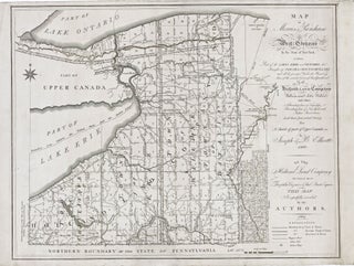
New York State/ Land Speculation. ELLICOTT, J. & B. [Philadelphia: 1801/ 1804] Map of Morris's Purchase or West Geneseo in the State of New York: Exhibiting Part of the Lakes Erie and Ontario, the Straights of Niagara, Chautauque Lake and All the Principal Waters ... Purchased by the Holland Land.....
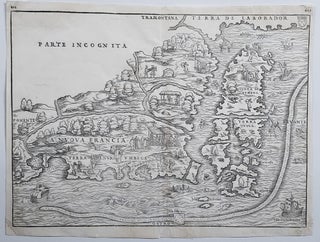
New England/ New York City. RAMUSIO, J. B./ GASTALDI, G. [Venice, 1556] La Nuova Francia. 10 1/2 x 14 1/2 inches. Woodcut map. A few minor marginal repairs, else excellent condition. .....
This very early map reveals the state of geographic knowledge of the Northeast and Mid-Atlantic regions at the time of their initial colonization. "A superbly executed engraving, [the map] depicts the northeastern American coastline as it was perceived by European geographers one hundred years after the discovery of the New World.....
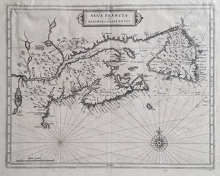
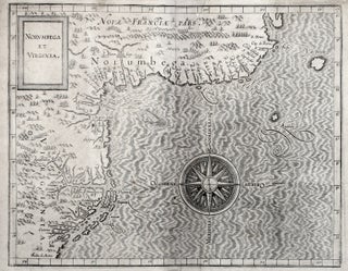
Canada/ Lake Champlain/ Maine/ Northern New England. DE LAET, Johannes/ GERRITSZ, Hessel [Leiden: 1630] Nova Francia et Regiones Adiacentes. 13 ½ x 16 inches. Copperplate engraving. Full margins, a few light stains, creasing at upper left, overall very good condition. A finely engraved, landmark map, the earliest to show Lakes.....
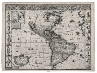
Western Hemisphere/ California as Island. SPEED, J. [London, 1626/ 1631] America with those known parts in that unknowne world both people and manner of buildings . . . 15 3/8 x 20 ¼ inches. With a strong, dark printing impression; excellent condition. .....
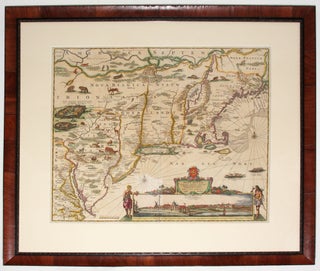
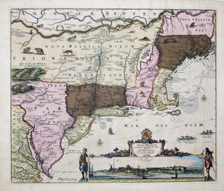
This is the most lavishly decorative of all the early editions of the best 17th century, Dutch map of the Northeast and New York. It added illustrations of animals and other detail not found on previous issues. The map was the culmination of all the surveys of the area conducted.....