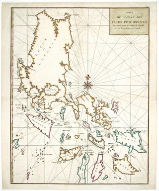
Philippines. ANSON, G. [London: 1749] Carte du Canal des Isles Philippines. 21 x 16 ½ inches. Fine hand color; excellent condition. A handsome chart.....
Philippines. ANSON, G. [London: 1749] Carte du Canal des Isles Philippines. 21 x 16 ½ inches. Fine hand color; excellent condition. A handsome chart.....
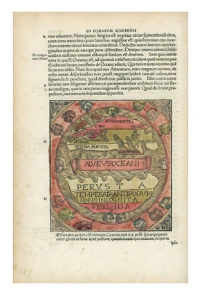
MACROBIUS, A. T. Macrobii Aurelii Theodosii Viri Consularis in Somnium Scipionis Li-bri Duo: Et Septem Eiudem Libri Saturna Lioru…Apud Sanctam Coloniam Anno M. D. XXI. Cologne: Eucharius Cervicornus, August 1521. Small folio ( 31 x 22.5 cm.) in 19th c. quarter red morocco, marbled paper over boards with considerable wear.....
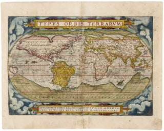
A very early issue of the stately world map that appeared in the first modern atlas; it provided the picture of the world that would prevail for many decades to come. Using the freshest information available, Ortelius employed as his chief source Mercator’s profoundly important world map of 1569, on.....
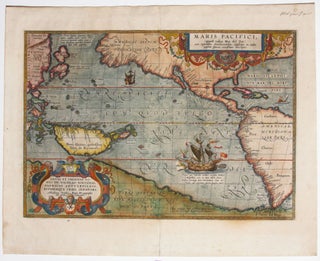
The first separate map of the Pacific in a strong example. “One of the most important maps that appeared in the Ortelius atlases ...” (Burden). With its two splendid cartouches and a well-detailed illustration of Magellan’s flagship, the Victoria, this is also one of the most beautifully engraved of Ortelius’.....
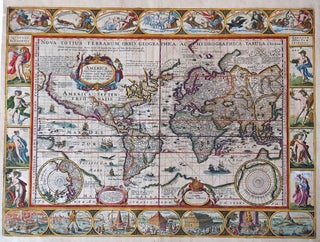
World/ Northwest Passage/ Australiana. KEERE, P. VAN DEN/ JANSSON, J. [Amsterdam, 1621/c. 1636] Totius Terrarum Orbis Geographica ac Hydrographica Tabula. 15 1/2 x 21 inches. Fine hand color; a few mended, inconspicuous into engraved surface & along a vertical crease, largely in margins, good overall. .....
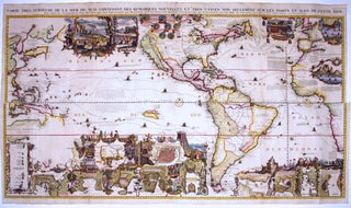
A splendid example, with rich, vibrant hand color, of a wall map of extraordinary intricacy and detail: "one of the most decorative maps of North America of the 18th century" (Tooley). Its elaborate illustrations provide a panorama of the Discovery Period, colorfully depicting the mores, rituals and practices of indigenous.....
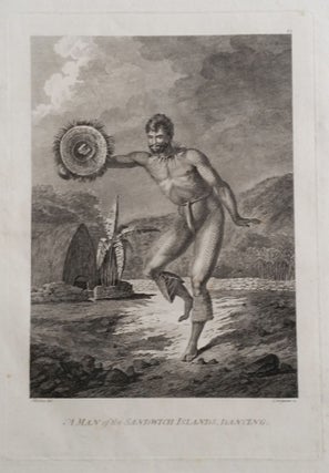
WEBBER, John (1752-1793) artist [London: G. Nicol & T. Cadell, 1784]. A Man of the Sandwich Islands, Dancing. Etched and engraved by C. Grignion after a drawing by Webber. Image size: 10 1/4 x 7 inches. Sheet size: 16 ½ x 14 inches. Lightly toned, faint tide mark upper right margin, faint.....
![Item #10137 The Cerographic Missionary Atlas… [Imprint inside front cover:] Entered according...](https://rtamaps.cdn.bibliopolis.com/pictures/10137.jpg?width=320&height=427&fit=bounds&auto=webp&v=1658773966)
An unusually well-preserved, scarce, and quite early American atlas of areas where missionary activity was being, or could be conducted. Includes an excellent map exclusively of the Hawaiian Islands. A map entitled “Indian Territory” encompasses Texas and east from Lake Superior and the Mississippi River to the Rocky Mountains in.....
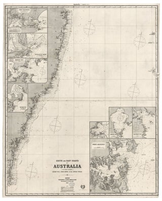
Southeast Australia/ Sydney. JAMES IMRAY AND SON [London: 1883 [1885 (stamped)] South And East Coasts Of Australia [In Four Charts] Chart No. 3, Cape Howe To The River Tweed…50 x 40 inches (127 x 101.6 cm). Two joined, lithographed sheets mounted on heavy, later blue paper with original yellow, trade.....
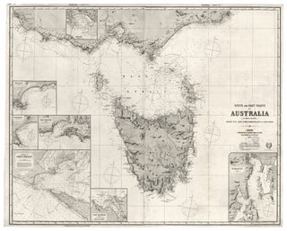
Southern Australia/ Melbourne/ Tasmania. JAMES IMRAY AND SON [London: 1883 [1885 (stamped)] South And East Coasts Of Australia [In Four Charts] Chart No. 2, Cape Northumberland To Cape Howe…40 ¼ x 50 inches (102.3 x 127cm). Two joined, lithographed sheets mounted on heavy, later blue paper with original yellow, trade.....
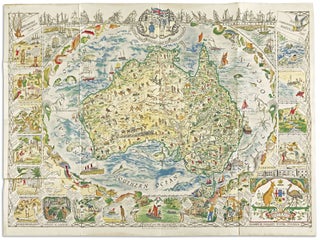
Australia/ Cartographic Education. SPILHAUS, Margaret Whiting/ GEORGE PHILIP AND SON, LTD. [London, c. 1929] Australia… 28 ¼ x 38 ¾ inches, 72 x 98.5 cm. Lithographed, folded, linen-lined map as issued; fine condition. .....