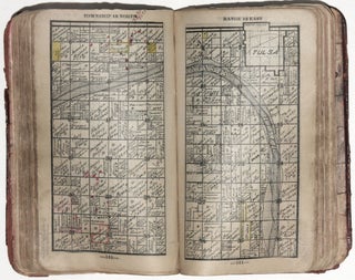
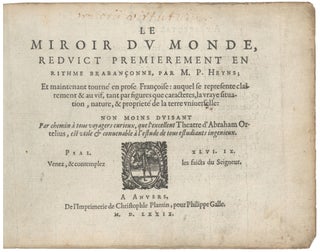
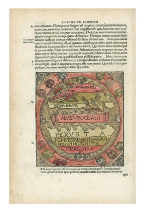
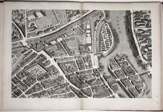
Atlas. ORTELIUS, A./ GALLE, F. [Antwerp, 1579] Le Miroir Du Monde, Reduict Premierement En Rithme… A Anvers, De l’Imprimerie de Christofle Plantin, pour Philippe Galle. M.D.LXXIX.Oblong octavo in contemp. Vellum, ties lacking; 72 maps, 6 of which folding; slight edge wear to text leaves, partial cropping to some folding maps for.....
Atlases & Books With Maps
Plan de Paris Commence l’Annee 1734.... Leve et Desine par Louis Bretez Grave par Claude Lucas / Et Ecrit par Aubin.
One of the most ambitious and finely engraved works of urban cartography ever produced: it depicts every structure existing in Paris at the time. This remarkable engraving enables the viewer to virtually hover a few hundred feet above the city and take in the exquisite details of its architectural glories.....
Out of stock
MACROBIUS, A. T. Macrobii Aurelii Theodosii Viri Consularis in Somnium Scipionis Li-bri Duo: Et Septem Eiudem Libri Saturna Lioru…Apud Sanctam Coloniam Anno M. D. XXI. Cologne: Eucharius Cervicornus, August 1521. Small folio ( 31 x 22.5 cm.) in 19th c. quarter red morocco, marbled paper over boards with considerable wear.....
The Cerographic Missionary Atlas… [Imprint inside front cover:] Entered according to Act of Congress, in the year 1848, By Se. E. Morse & Co.,….
An unusually well-preserved, scarce, and quite early American atlas of areas where missionary activity was being, or could be conducted. Includes an excellent map exclusively of the Hawaiian Islands. A map entitled “Indian Territory” encompasses Texas and east from Lake Superior and the Mississippi River to the Rocky Mountains in.....
Hastain's Township Plats of the Creek Nation.
A scarce, pocket land atlas, made for use in the field, of the properties owned by members of the Five Civilized Tribes--the Creek, Seminole, Cherokee, Choctaw and Chickasaw nations. The work remains to this day one of the best and most reliable sources for locating original land ownership titles in.....