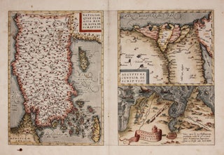
ORTELIUS, Abraham [Antwerp: 1570] Natoliae.../ Aegypti.../ Carthaginis... 12 1/2 x 19 1/4 inches. Fine hand color; reinforced bottom of centerfold, few edge mends, ink stain lower left, still very good condition overall.A very early issue from a 1570 edition, the year of the first appearance of Theatrum Orbis Terrarum, the first modern atlas. Three editions.....
Turkey & Middle East
Aden, Arabiae Foelicis Emporium….
One of relatively few engravings by Braun & Hogenberg of non-European locales. The earliest acquirable European view of Aden in Yemen, the Arabian port commanding the passage between the Red Sea and the Indian Ocean. Also pictured are Mombasa in Kenya, Kilwa in Tanzania, and Sofala in Mozambique, all on.....
Map Of The Balkan Peninsula….
A rare, clearly printed, political map of this volatile region, described as "entirely new" in the advertisement included here. Although the map is not dated, the Royal Geographic Society reported its acquisition of an example in July of 1914 (see below). Since the Archduke Franz Ferdinand was assassinated on June.....
Iraq/ World War I. PERVITITCH, Jacques [Jakub PERVITIĆ] [Constantinople: c. 1918] Irak. 18 ½ x 23 inches (47 x 58.5 cm. Color lithography, with some contemporary manuscript additions in pencil, bearing stamp of "J. Pervititch Constantinople." Mended marginal split, a few penetrating printed surface, some staining & creasing, yet still.....
Out of stock
Asia To Major James Rennell, Esqr. F. R. S. &c. &c. This Map Is Inscribed, by His much Obliged Humble Servant January 1st 1801. A. Arrowsmith.
Very scarce, sole edition of Arrowsmith's large, folding map of Asia, the most accurate of the continent available at the time. It bears all the hallmarks that made his maps models of clarity and accessibility. "It is a significant advance on other maps of the period, incorporating the work of.....