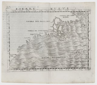
Northeast-Southeast/ New York City/ Bermuda. GASTALDI, G. [Venice, 1548] Tierra Nueva. 5 1/4 x 6 3/4 inches. A fine example with an uncommonly strong impression. .....
Northeast-Southeast/ New York City/ Bermuda. GASTALDI, G. [Venice, 1548] Tierra Nueva. 5 1/4 x 6 3/4 inches. A fine example with an uncommonly strong impression. .....
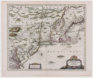
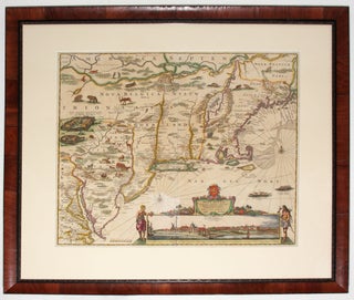
Northeast/ New York City. JANSSON, J. [Amsterdam, 1651] Belgii Novi, Angliae Novae, Et Partis Virginiae Novissima Delineatio. 17 ¼ x 20 ¼ inches. Superb original color; a few vertical creases else excellent with wide margins. .....
A map that is as historically important as it is attractive: it was the culmination of all the surveys conducted by the Dutch colonists of New Netherlands during their first three decades in America. It is also the first printed map to delineate the shape of Manhattan with relative accuracy;.....
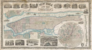
PHELPS, Humphrey [New York: 1857] Phelps' New York City Map, With Portions of Brooklyn, Jersey City, Williamsburgh, Greenpoint, Astoria, and Hoboken… 25 x 45 ¾ inches. 25 x 45 ¾ inches. Lithographed wall map with fine original color, refreshed; professionally conserved & re-backed, with some stabilized tears and a few.....
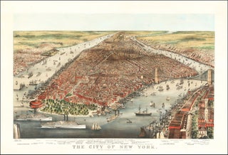
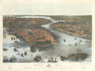
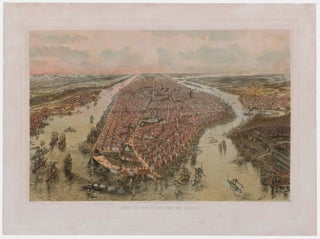
Brooklyn Bridge/ New York City. CURRIER & IVES/ PARSONS & ATWATER (artists & lithographers) [New York: 1876] The City of New York. 22 x 33 ¼ inches. Color lithograph; mounted on heavy stock; a few minor abrasions, else fine condition. A breathtaking bird’s-eye view capturing the dynamism and animation of.....
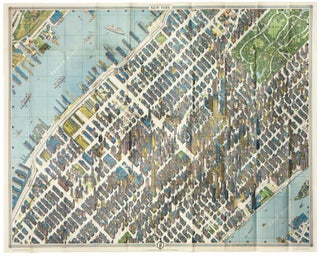
New York City/ Architecture/ Graphic Arts. BOLLMANN, H. [New York, 1963 [1964]New York Map-Guide. 33 ¾ x 44 ½ inches. Color-printed folding view of Midtown with a regional map on the verso, with original covers containing a 48 pp. booklet. Very slight fold wear to map, else excellent. .....
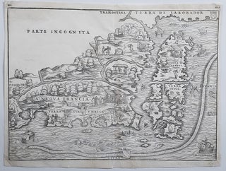
New England/ New York City. RAMUSIO, J. B./ GASTALDI, G. [Venice, 1556] La Nuova Francia. 10 1/2 x 14 1/2 inches. Woodcut map. A few minor marginal repairs, else excellent condition. .....
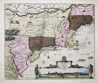
This is the most lavishly decorative of all the early editions of the best 17th century, Dutch map of the Northeast and New York. It added illustrations of animals and other detail not found on previous issues. The map was the culmination of all the surveys of the area conducted.....
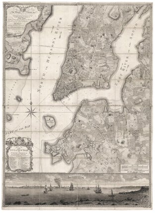
Rare; a superb example of the best executed and most beautiful, printed map one can acquire of early New York, and arguably, the masterpiece of 18th century, American, urban cartography. In addition to a plan of the city itself, the work provides a remarkable evocation of the pre-development landscape of.....
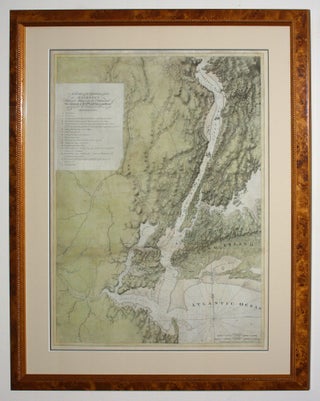
"One of the greatest of the Atlantic Neptune charts, with the best topographical information on the lower Hudson River valley, western Long Island, and Staten Island” (Nebenzahl, Bibliography). A rare and highly evocative map that provides a cartographic overview of both the ground and naval actions of the Revolutionary War.....
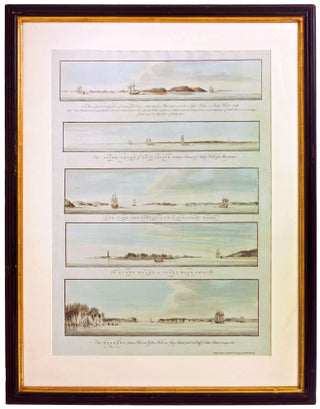
New York City/ American Revolution/ Navigation. DES BARRES, J. F. W. [London, Octr. 4, 1777] Five Profile Views from Various Points in New York Harbor, Including One Showing the City Itself. 28 x 18 ¼ inches. Aquatints with delicate, original wash color; fine condition. .....
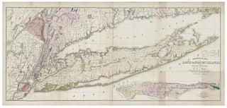
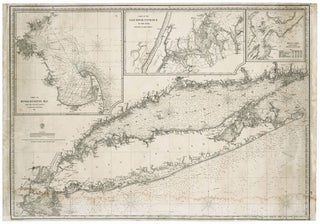
Long Island/ Manhattan/ Geology. MATHER, W. W./ SMITH, T. C. [New York?, 1842] Geological Map of Long & Staten Islands with the Environs of New York… 22 x 50 inches. Folding, lithographed map with fine, full original wash color; a few, confined toned areas, else fine condition. .....
BACHMANN, John / SCHEDLER & LIEBLER [New York: 1851] Bird's Eye View of New-York & Brooklyn. 25 x 32 ½ inches. Lithograph delicately finished with hand color. Mounted on rice paper, a few minor repairs, else excellent. .....
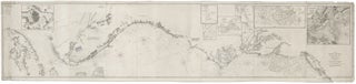
Nautical Chart: Block Island to Cuba. BLUNT, E. & G. W./ COPLEY, Charles [New York, 1853] Coast Of North America from Point Judith to Cape St. Antonio. (Island Of Cuba) Including The Bhama Banks… Every Authentic Survey, American, English & Spanish, Has Been Used In The Construction Of This Chart… 29.....
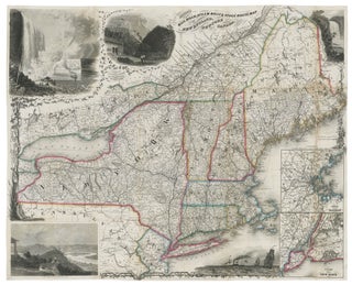
Northeast/ Canada/ Transportation History. SMITH, J. Calvin [New York: 1855/ 1858] Smith’s Rail Road, Steam Boat & Stage Route Map Of New England, New-York And Canada. By J. Calvin Smith. Published by J. Calvin Smith71 Nassau St. N.Y. MDCCCLVIII. 22 X 26 ¾ inches. Folding map, here flattened & mounted.....
Rare. This was as authoritative a chart of these waters as was available at the time. Despite its density of detail, the chart was engraved with uncommon clarity. Its delineation of the Connecticut shoreline includes the many, small harbor islands, especially along the western shore. Also, all inlets, rivers and.....
New York City. BACHMANN, J./ KIMMEL & FORSTER [New York, 1865] Birds Eye View Of New York And Environs. 12 ¼ x 18 inches. Hand colored lithograph; excellent condition. Very scarce, delicately executed and colored bird’s-eye view of New York City as it was at the end of the Civil.....
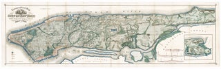
Manhattan. VIELE, Egbert L. [New York, 1865] Topographical Map of the City of New York,… 18 x 62 ½ inches. Lithograph with original hand color; flattened & mounted on rice paper, light discoloration & a few reinforcements at some folds, else excellent. With pamphlet (13 pp) describing the map and.....
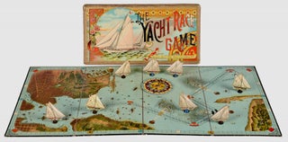
New York City & America’s Cup History. MCLOUGHLIN BROS. [1887 (copyright)/ 1888 (published)] The Yacht Race Game. Large folding game board, 31 ¼ x 16 inches. With spinner in the form of a compass and 8 (of 8) playing pieces in the form of yachts on wooden supports. All housed in.....
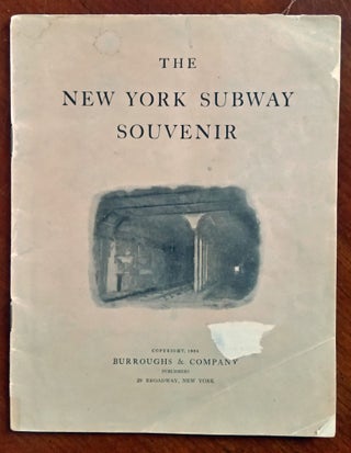
New York City. BURROUGHS & COMPANY [New York, 1904] The New York Subway Souvenir. 9 ¼ x 7 1/8 inches. Paper covers. 47 pp. with several photos, advertisements, and a double-page subway map. Some staining, scuffed area, & minor edge chipping to front cover; internally paper a bit age-toned, still.....
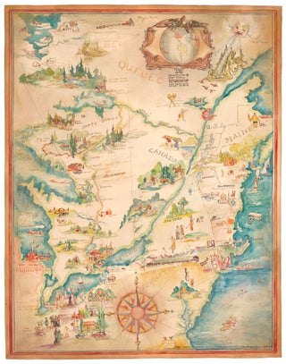
Pictorial Map/ United States/ Canada. CASS, Katherine "Kae" Dorn [Cleveland, Ohio: 1928] Untitled Manuscript of the Northeast & Midwest U. S. & Part of Canada. 26 ¾ x 21 inches. Watercolor & ink on poster board; excellent condition. Highly animated and well-executed biographical map chronicling the travels, activities, adventures and.....
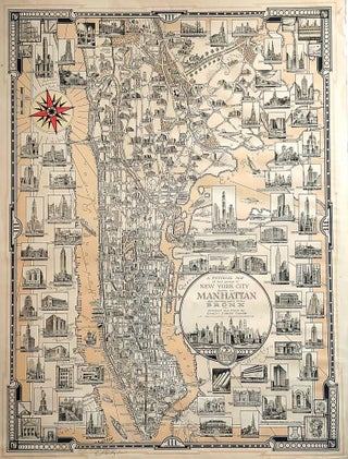
New York City. CHASE, Ernest Dudley [Winchester, MA: dated 1939] A Pictorial Map of that portion of New York City known as Manhattan also showing parts of the Bronx . . . 20 ½ x 27 ½ inches. Artist's signature in pencil lower left below copyright. Some chipping & mended splits.....
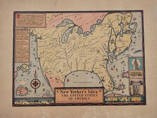
New York City/ Humor. WALLINGFORD, Daniel K. [New York: 1939] A New Yorker’s Idea of the United States of America. 11 ¾ x 15 7/8 inches. Color print. Mounted on acid-free paper, lightly toned, marginal chipping & creasing, still overall very good. Delightful satiric map.....
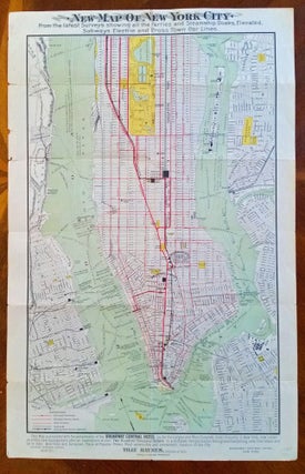
New York City/ Subway History. BROADWAY CENTRAL HOTEL/ BROOKS BANK NOTE CO. [Boston: n.d., c. 1905] New Map Of New York City. 21 5/8 x 12 inches. Color lithographed folding map; slight edge chipping else excellent. [Title on verso: New Reference Map & Guide To New York City… Text.....
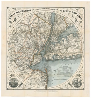
New York City/ New Jersey. G. W & C. B. COLTON & CO. [New York, 1889/ 1895] Map of the Country Thirty Three Miles Around The City of New York. 22 ¼ x 21 inches. Original wash & outline color; ex folding map with original cover, separate, map here flattened.....