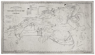
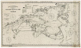
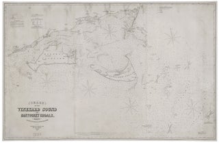
Nantucket/ Martha’s Vineyard/ Cape Cod. ELDRIDGE, G. [Boston, 1857/ 1874] Chart of the Vineyard Sound and Nantucket Shoals… 40 ½ x 62 ½ inches. Lighthouses and other navigational aid highlighted in color; expertly conserved & re-mounted on new linen, margins extended, some relatively light staining, early notations in pencil, still.....
Results
Results 1 - 3 (of 3)
Out of stock
Geo. W. Eldridge’s Chart C Vineyard Sound Lt-Ship to Chatham.
An uncommonly fine example of this scarce, well-detailed yet highly legible, nautical chart of the challenging waters in the area of Martha’s Vineyard and Nantucket. It is rich with navigational detail vital to anyone plying these problematic seas, all of which is presented with Eldridge’s characteristic clarity. In addition to.....
Nantucket/ Martha’s Vineyard/ Cape Cod. ELDRIDGE, George [Boston: 1914/ 1915 (stamped)] Geo. W. Eldridge’s Chart C Vineyard Sound Light-Ship to Chatham. 27 ¼ x 47 ½ inches. Lithograph mounted on original linen as originally issued, with identifying label & price list of available charts by Eldridge pasted on back; minor.....
Results 1 - 3 (of 3)


