
World/ Age of Discovery. SCHEDEL, Hartmann [Nuremberg: 1493] Secunda etas mundi. 14 ½ x 20 inches. Original woodcut; usual thread hole mends, else fine condition. .....
World/ Age of Discovery. SCHEDEL, Hartmann [Nuremberg: 1493] Secunda etas mundi. 14 ½ x 20 inches. Original woodcut; usual thread hole mends, else fine condition. .....

China/Japan/ Tibet/ Indochina. FRIES, Laurent [Vienne: 1541] Untitled Woodcut Map of East Asia. 11 ½ x 18 inches. A few, filled small wormholes in outer margins, else excellent condition with a strong printing impression. .....

Northeast-Southeast/ New York City/ Bermuda. GASTALDI, G. [Venice, 1548] Tierra Nueva. 5 1/4 x 6 3/4 inches. A fine example with an uncommonly strong impression. .....

Asia. MUNSTER, S. [Basel, c. 1550] Tabula orientalis regionis, Asiae scilicet extremas complectens terras & regna.. 10 ½ x 13 ½ inches. Excellent condition. The earliest separate map specifically of Asia. Munster’s striking woodcut map significantly.....

Americas. ORTELIUS, A. [Antwerp: 1570 [1571]] Americae Sive Novi Orbis, Nova Descriptio. 14 ½ x 20 inches. Fine original color, refreshed; mended split in left margin just entering surface, very slight fold wear, excellent condition with a sharp impression. .....

World. BLAEU, Willem. [Amsterdam: c. 1630-1635] Nova Totius Terrarum Orbis. 16 x 21 3/8 inches. Fine original color, refreshed; light matt burn, else a fine example with a strong impression. A beautiful example of an early issue of a cartographic masterwork. While the exact issue date of this Blaeu.....

North America/ California as an Island/ Great Lakes. JANSSON, J./ HONDIUS, H. [Amsterdam, 1641] America Septentrionalis. 18 1/4 x 21 1/2 inches. Fine original color; fine condition. One of the earliest maps to focus.....

Northeast/ New York City. JANSSON, J. [Amsterdam, 1651] Belgii Novi, Angliae Novae, Et Partis Virginiae Novissima Delineatio. 17 ¼ x 20 ¼ inches. Superb original color; a few vertical creases else excellent with wide margins. .....

Ptolemaic Solar System. CELLARIUS, Andreas. [Amsterdam, 1660] Planisphaerium Ptolemaicum… 17 3/8 x 20 5/8 inches. Full rich original color heightened with gold; bottom of centerfold reinforced, else a fine example. In a fine, archival, gold-leaf frame. .....

Copernican Solar System. CELLARIUS, A. [Amsterdam, 1660] Scenographia Systematis Copernicani. 17 x 20 1/2 inches. Superb original color, heightened with gold; fine condition. In a fine, archival frame. .....

Connecticut/ Long Island Sound/ Rhode Island. GENTLEMEN’S MAGAZINE [London: November, 1776] A Map of Connecticut and Rhode Island with Long Island Sound,&c. 6 ¾ x 8 ⅞ inches. Copperplate engraving. slight text offsetting on right side, else excellent. .....
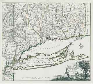
Connecticut. ROMANS, B./ COVENS & MORTIER & COVENS [Amsterdam, 1780] Connecticut and Parts adjacent… 20 ½ x 23 ¼ inches. Copperplate engraving with original outline color; all edges deckled, uncut; mint condition; in a fine archival frame. Very rare; separately published. The earliest acquirable map of Connecticut.....

HOWELL, Reading (surveyor) / PHILLIPS, James (printer) [Philadelphia: Reading Howell: 1792 [but ca. 1794] A MAP OF THE STATE OF PENNSYLVANIA, BY READING HOWELL, MDCCXCII. Engraving on four sheets, 37 x 63 inches if joined. Lightly cleaned, minor mends, and some vertical folds from storage, yet overall a superb example. .....

Connecticut. SOTZMANN, D. F. [Hamburg: 1796] Connecticut entworfen van D. F. Sotzmann… 14 x 17 1/8 inches. Full original wash color; fine condition with very wide margins. Separately published. One of the most advanced and detailed maps of Connecticut to date. Sotzmann's.....

United States. FADEN, W. [London, 1796] The United States of North America with the British Territories and Those of Spain. According to the Treaty, of 1784. 20 ½ x 24 ¾ inches. Full original wash and outline color; excellent condition. .....

SOTZMANN, Daniel Friedrich/ EBELING, Christoph [Hamburg: Carl Ernst Bohn, 1798. MAINE entworfen von D.F. Sotzmann. 25 ¼ x 17 3/8 inches. Copperplate engraving with original wash and outline color. Some discoloration from liquid damage at left along centerfold, with some old repairs and a recent mend to a short tear to.....
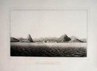
Rio De Janeiro. SYDENHAM, Thomas, Esq. / ORME, Edward [London: January 1, 1812] Entrance of the Harbour of Rio Janeiro. London: Pubd. Jan. 1 1812, by Edwd. Orme, Printseller to the King, Engraver & Publisher, Bond Strt. Corner of Brook St. 10 x 14 ¼ inches. Excellent condition. .....
![Item #11075 FIRST VIEW of the BATTLE of PATAPSCO NECK [:] DEDICATED TO THOSE WHO LOST THEIR...](https://rtamaps.cdn.bibliopolis.com/pictures/11075.jpg?width=320&height=427&fit=bounds&auto=webp&v=1585677032)
Extremely rare, unrecorded proof (or first) state, by an American participant, of the September 1814 Battle of North Point, at which Maryland militia stoutly defended Baltimore against a large force of British regulars.The early land campaigns of the War of 1812 took place along the Canadian border, but in mid.....
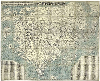
World Map/ Buddhism. Zuda RŌKASHI (Priest Hōtan) [Kyōto, c. 1710-1815] Nansen Bushu Bankoku Shōka No Zu. (“Outline Map of all the Countries of the Universe”) 45 x 57 ½ inches. Period wash color; nine woodblock sheets joined; folds reinforced, slight losses at some fold intersections, overall very good. .....
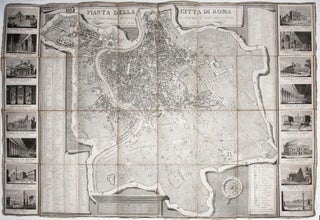
Large, attractively engraved plan of Rome, flanked by 16 vignettes, each approximately 4 x 5 inches, of the city's most prominent ancient and modern structures. Included among the latter are the Pantheon of Agrippa, Trajan's Column, and the Colosseum; among the former are the basilicas of St. Peter, St. John.....

New Jersey. GORDON, Thomas [Philadelphia, 1828] A Map of the State of New Jersey with part of the Adjoining States... 32 ½ x 55 ¼ inches. Engraved map, segmented and mounted to original linen backing with powder blue silk selvage as originally issued, folding into marbled paper self-wrappers. Vibrant original.....
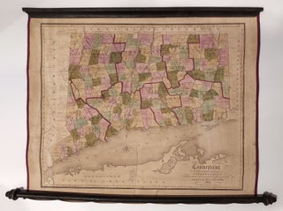
Connecticut. WARREN & GILLET/ GEORGE GILLET ESQ./ WILLARD, A. (PUBLISHER) [Hartford, 1847] Connecticut from the actual Surveys of Warren & Gillet With addition of new towns turnpike roads &C by George Gillet Esqr. 17 5/8 x 21 ¾ inches. Lithograph with original hand color, refreshed; expertly conserved & re-backed with.....
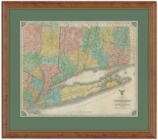
Connecticut. NEVERS, R./ DAMERUM, W. [Hartford, 1851] The State of Connecticut including Parts of New York and New Jersey. 23 x 28 ¼ inches (engraved area only. Original wash hand color, refreshed; re-mounted on new linen & expertly conserved; toned, some spotting, a few splits but overall very good. In.....
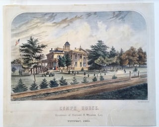
BONAR, Thomas [New York, c. 1855] Compo House. The Residence of Richard H. Winslow Esq. at Westport, Conn. 17 ¼ 21 ¼ inches. Color lithograph. Expertly mounted on acid-free paper; well-mended split lower right imperceptibly extending into printed surface, light mat burn, very good overall. .....
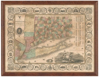
The State of Connecticut with all the new towns, including Parts of New York and New Jersey. 23 x 33 inches. Lithograph with original hand color, refreshed; wall map expertly conserved & re-mounted on new linen; relatively minor cracking, excellent of this type. Elegantly framed. .....