The World of the Early 18th Century in a Large, Beautiful, English Map
MOLL, Herman. [London, 1719]
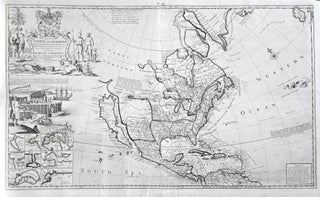
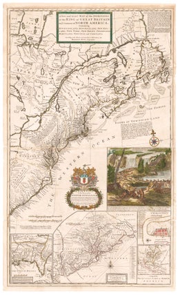
World/ California as an Island. MOLL, H. [London: 1719] A New & Correct Map Of The Whole World… 27 ¼ x 47 inches. Original outline color refreshed; mounted on rice paper, mended minor fold wear & separations, still an overall excellent, attractive example with a strong printing impression. .....
Moll's Cod Fisheries Map of North America in an Excellent Example
MOLL, Herman. [London, 1720]
North America/ California as Island. MOLL, H. [London, 1720] To the Right Honourable John Lord Sommers . . . This Map of North America . . . 22 5/8 x 38 inches. Original outline color; few, small wormholes in upper margin, reinforcement in lower margin, else excellent condition. .....
The Beaver Map — An Icon of American Cartography
In a Full Original Color
MOLL, Herman. [London, 1715/ 1731]
North America/ Postal History/ Carolinas. MOLL, H. [London, 1715/ 1731] A New and Exact Map of the Dominions of the King of Great Britain on ye Continent of North America. ... By Herman Moll Geographer. ... 39 5/8 x 23 7/8 inches. Full original color; lightly toned, some folds reinforced.....