![Item #10137 The Cerographic Missionary Atlas… [Imprint inside front cover:] Entered according to Act of Congress, in the year 1848, By Se. E. Morse & Co.,…. SIDNEY E. MORSE, CO.](https://rtamaps.cdn.bibliopolis.com/pictures/10137.jpg?width=768&height=1000&fit=bounds&auto=webp&v=1658773966)
click here to zoom
![The Cerographic Missionary Atlas… [Imprint inside front cover:] Entered according to Act of Congress, in the year 1848, By Se. E. Morse & Co.,…](https://rtamaps.cdn.bibliopolis.com/pictures/10137_2.jpg?auto=webp&v=1658773966)
![The Cerographic Missionary Atlas… [Imprint inside front cover:] Entered according to Act of Congress, in the year 1848, By Se. E. Morse & Co.,…](https://rtamaps.cdn.bibliopolis.com/pictures/10137_3.jpg?auto=webp&v=1585677021)
![The Cerographic Missionary Atlas… [Imprint inside front cover:] Entered according to Act of Congress, in the year 1848, By Se. E. Morse & Co.,…](https://rtamaps.cdn.bibliopolis.com/pictures/10137_4.jpg?auto=webp&v=1585677021)
The Cerographic Missionary Atlas… [Imprint inside front cover:] Entered according to Act of Congress, in the year 1848, By Se. E. Morse & Co.,….
12 x 13 ½ inches, Oblong quarto in original tan wrappers; 18 wax-engraved maps; relatively light wear to covers and maps with occasional light foxing, evidence of having been vertically folded, still excellent condition of its kind.
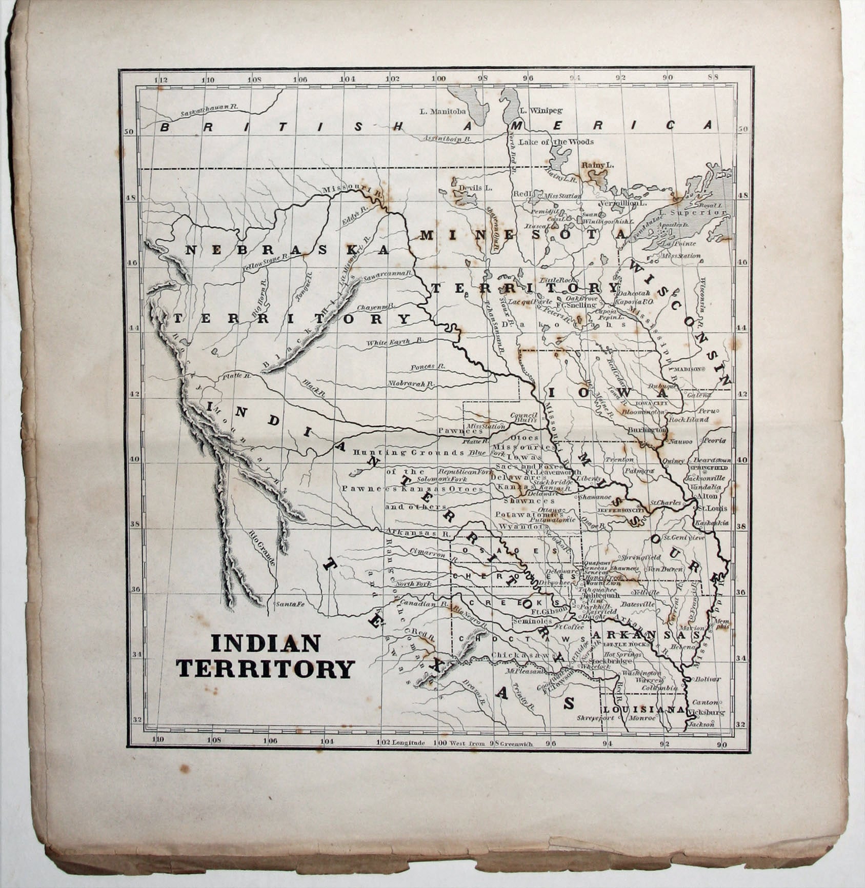
An unusually well-preserved, scarce, and quite early American atlas of areas where missionary activity was being, or could be conducted. Includes an excellent map exclusively of the Hawaiian Islands. A map entitled “Indian Territory” encompasses Texas and east from Lake Superior and the Mississippi River to the Rocky Mountains in the west. The map notes Indian tribes, forts and settlements. The atlas includes maps of what are today still remote places, such as one called “Country of the Nestorians” which in present-day southern Iraq. There are also maps of China, Palestine, Turkey, one of Greenland, four of India, and three of Africa.
The atlas was given gratis to subscribers of The New York Observer, a weekly religious journal founded by Morse. Sidney Morse was the son of Jedidiah, who was a Congregational minister as well as geographer and publisher. The atlas is also of interest for the then new printing process it utilized—cerography or wax engraving—invented by Sidney Morse with Henry A. Munsen in 1834. (Morse’s brother, Samuel, invented the telegraph.) The process was intended specifically for the printing of maps and was indeed much faster and cheaper than copperplate engraving but not nearly as refined as lithography, which rather than cerography eventually supplanted copperplate engraving. With the distribution of this work, Morse was most likely trying to both further religious ends as well as promote his printing process. He also provided to Observer subscribers the Cerographic Atlas of the United States (1842-45) and the Cerographic Bible Atlas (1844).
* Ristow, W. American Maps, p. 154; Phillips 182; Rumsey 4685.019.
Sold