click here to zoom
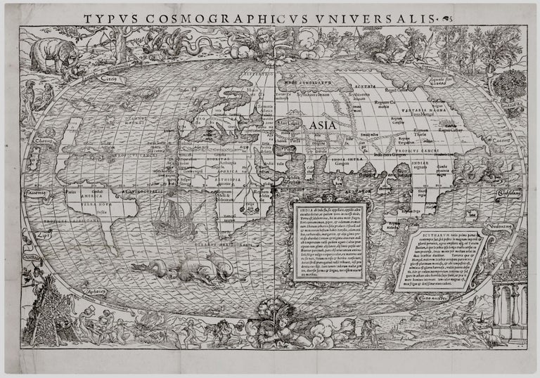
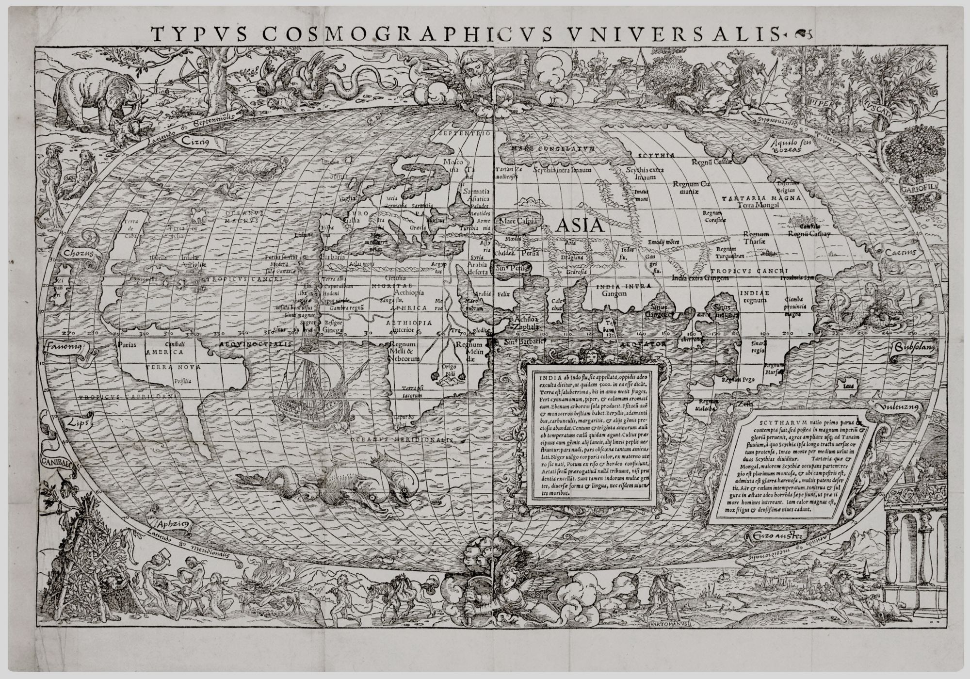
World. GRYNAEUS, S./ MUNSTER, S.(?)/ HOLBEIN the Younger, H. [Basel, c. 1532] Typus Cosmographicus Universalis. 14 ¾ x 22 inches. Woodcut printed on two joined sheets; very good condition overall; see below for details. An attractive example of this highly evocative Discovery-era world map. No printed world map obtainable by the collector today more vividly summons the outlook of the Age of Discovery. “From the artistic point of view it is one of the most interesting of the many world maps turned out in the sixteenth century” (The World Encompassed 65). Printed from two woodblocks, this map often suffered from uneven printing impressions on each of its side; here the printing strike is uniformly firm over the entire printed image. The map’s finely wrought border ornamentation has been attributed to the great German artist, Hans Holbein, the Younger, who in addition to having been the preeminent portrait painter in the court of Henry VIII, worked with several publishers in Basel where this map was published. The realism of the map’s imagery and the grace of the woodcutting certainly bear out this attribution. Moreover, Holbein’s involvement is supported in the fine catalogue that accompanied a major exhibition on early prints, particularly the woodcut, that was mounted by the Harvard Art Museums in 2011; see reference below. It is noted in the catalogue that it is an established fact that Holbein created designs for the mapmaker and publisher Sebastian Munster, when both were in Basel in 1529 and 1531-32. It goes on to describe at some length the nature of their collaboration. In each corner of the map, the continents and key images associated with them during the Age of Discovery are represented: for Asia, the spices pepper, nutmeg and clove; for America, an elaborate tableau of cannibalism; and for Africa, exotic people and animals. Within the map are equally well-executed images of a ship, sea monsters, and a mermaid. The map itself has been attributed to the Swiss geographer, Sebastian Munster. The map reflects the fact that certain fundamental aspects of the geographical nature of the New World were becoming firmly established by the third decade of the 16th century (even though much of the map still relied for its general outlines on Waldseemuller’s wall map of 1507). Examples of this are the clear separation of North America and Asia as well as the growing realization that North America was itself a significant landmass. Also, when the map was published in 1532, the use of the place name ‘America,’ which is prominently shown in South America, was still at an early point of its use. Curiously, North America is called on the map “Terra de Cuba,” a designation for which we have found no explanation; Cuba itself appears with its normally found, early name, “Isabella.” North and South America, again curiously, are separated by a strait in the approximate location of the Panama Canal. Japan appears just off the West Coast of North America. A prescient feature of the map is the images of the angels above and below the earth turning handles, thus illustrating the concept of the earth spinning on its axis. Such an image would have been in direct conflict with the Church-endorsed, Ptolemaic conception of the solar system that posited a stationary earth at its center. The possibility of a heliocentric solar system that is at least implied by this map was roughly concurrent with Copernicus’ proposal of this concept, though 11 years prior to the actual publication of his conclusions. Condition: Both joined sheets with uniformly strong impressions, left margin expertly extended with no loss of printed surface, ample margins otherwise, long mended horizontal tear in left sheet, reinforcements at fold intersections, still an attractive example on fine paper. Shirley 67; (Exhibition Catalogue:) Dackerman, S. Prints and the Pursuit of Knowledge in Early Modern Europe, no. 84; Nordenskiold, Facsimile Atlas, pp. 105-06; Harley, J. B. Maps and the Columbian Encounter, pp. 84-86; Lester, T. The Fourth Part of the World, p. 393.
Sold