
click here to zoom
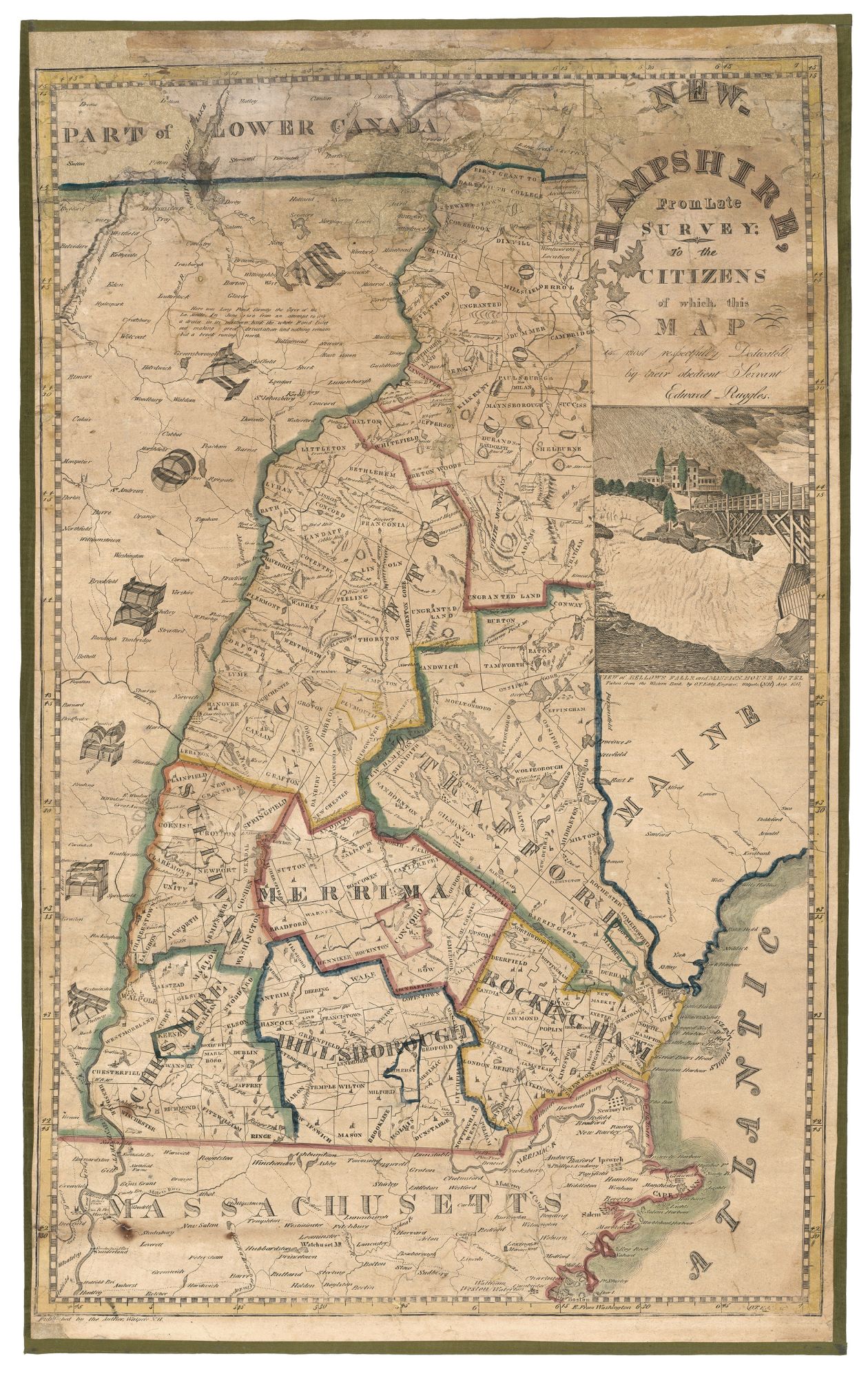
New Hampshire. RUGGLES, Edward/ EDDY, O. T. [Walpole, NH: 1817] NEW-HAMPSHIRE, From Late SURVEY; TO THE CITIZENS of which this MAP is most respectfully Dedicated by their obedient Servant Edward Ruggles. Engraving with outline color, refreshed, on two joined sheet: 29 x 18 ½ inches. Expertly conserved & fully stabilized, re-mounted on new linen with green silk selvage, some losses & cracking in top portion, two burn marks lower left, still quite good of this type. The second earliest map of New Hampshire published in the state, possessing the folk charm of a very early, regional American printing. Ruggles’ map was pretty much an outright piracy in reduced format of the first official map of the state, published by Carrigain in 1816, which was a large-scale wall map. Ruggles did replace the insets on Carrigain’s map with a view of Bellows Falls and the Mansion House Hotel, which was engraved by Eddy and dated 1817. Ruggles’ map shows the boundaries of the state’s counties, towns, and “ungranted” lands as well as its roads and waterways and the locations of churches and meeting houses. Some of the state’s nascent industries are shown, such as two iron factories in Franconia. The White Mountains and other ranges are crudely rendered. The map also includes eastern Vermont and a bit of Maine. Edward Ruggles remains an obscure figure as do a number regional “backwoods” mapmakers. He is known to have published a map of Massachusetts in 1819 and possibly one other of the United States after Shelton and Kensett. Ruggles is probably most remembered for the sharp denunciation he received from Carrigain for the piracy of his copyrighted map. It seems, though, that no legal measures were applied to Ruggles, perhaps due to the weakness of copyright protections at the time or Ruggles’ lack of mean. Much better known is the map’s engraver, Oliver Tarbell Eddy (1799-1868), born in Greenbush, Vermont and who learned engraving from his father Isaac, who also trained the better-known Vermont mapmaker Lewis Robinson (Ristow, American Maps and Mapmakers, p. 271). The younger Eddy’s primary profession was portrait painting, which he practiced as an itinerant artist in Newburgh, New York City, Newark, Baltimore and Philadelphia. Cobb, New Hampshire Maps to 1900, #94, cf. #129 (1837 edition); Rumsey 2990.
Sold