click here to zoom
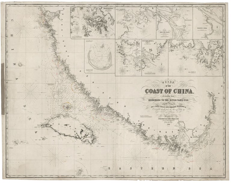
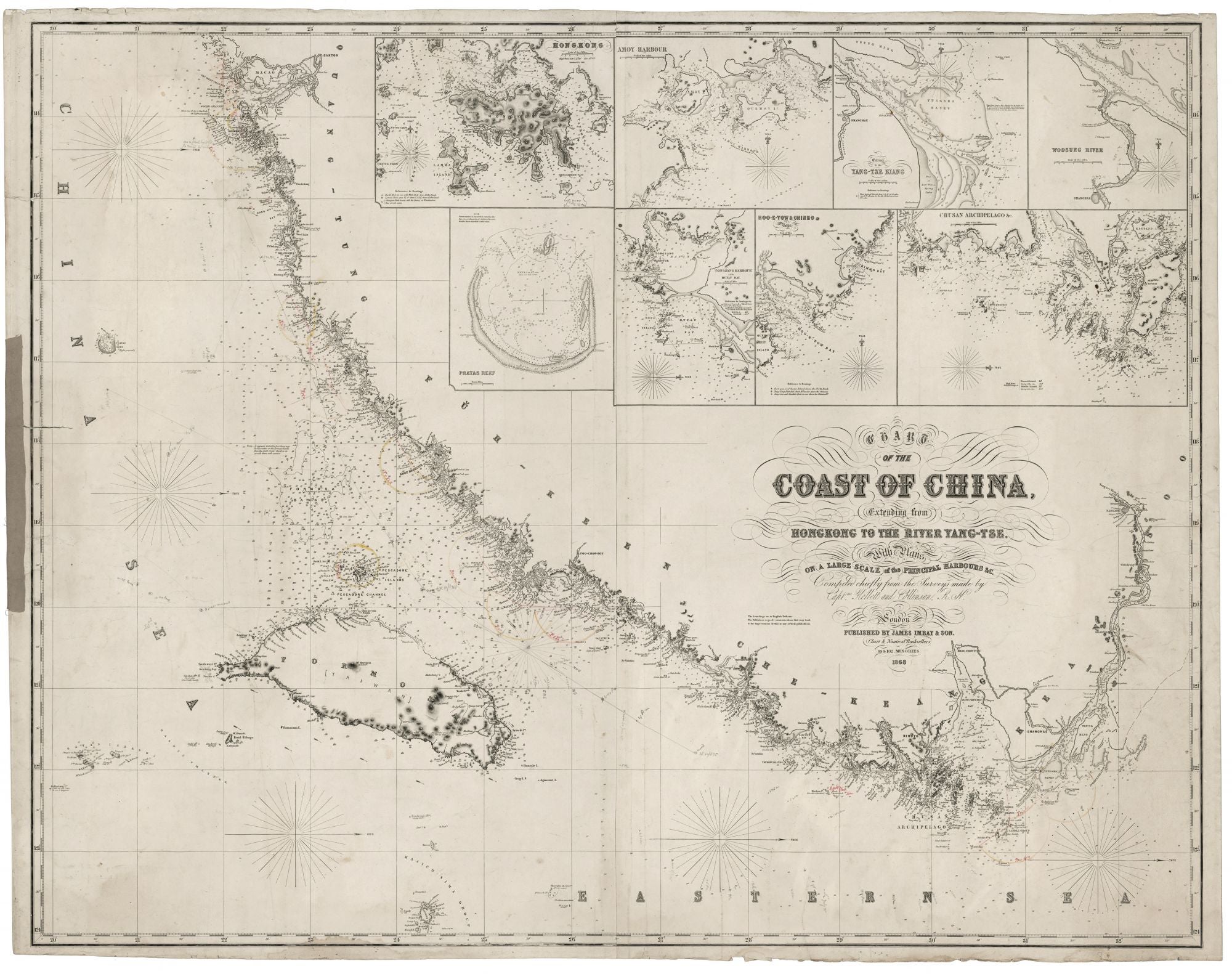
SE Coast of China: Hong Kong to Shanghai including Taiwan. JAMES IMRAY & SON [London: 1862] Chart Of The Coast Of China, Extending from Hongkong To The River Yang-tse… London… 89 & 102, Minories 1868. 38 ½ x 49 ½ inches (98 x 125 cm.) Two joined lithographed sheets mounted on later, heavy blue paper, with original, yellow trade label affixed. With eight, detailed insets of harbors & bays. Several, early navigational notations & courses in pencil & ink. Lightly toned overall, light tide mark lower left, some splitting & soiling along edges, crude cloth repair of 7cm split at left; still very good overall of this type, especially for an example that clearly saw considerable use at sea. This very rare and important chart focuses precisely on the area of China most vital to British commercial interests at the time—the coast line from Hong Kong to Shanghai and including both all of Taiwan and the Yangtze River inland to Nanjing. This edition of the chart is not in OCLC, and only two copies of other editions are to be found there. Similarly, we’ve found no record of this edition having been on the market previously, and three copies of other editions have appeared in the last twenty years. This chart was a crucial instrument of British commercial and imperial activities in China at a time when they were at or near their zenith. In 1860, largely by virtue of the Treaty of Tientsin, the British gained full control over Hong Kong, secured the legalization of the opium trade and navigation rights to the Yangtze River, and were allowed a diplomatic presence in Peking, from which the British could exert political influence on China’s internal affairs. In one way or another, all of these developments are reflected in this chart. The work’s eight detailed insets focus on vital commercial areas as well as reflect the penetration of British activity into China’s interior. Specifically, the insets depict the River Min, Amoy Harbor (Xiamen), Tongsang harbor, Hoo-e-Two and Chimmo Bays, the mouth of the Yangtze (depicting Shanghai), and the Chusan Archipelago (Zhoushan), and Hong Kong. Interestingly, this edition of the chart, unlike an earlier edition of 1855 we’ve seen, notes “Taiwan” as alternate place name for Formosa; “Taiwan” did not come into common usage among Europeans until the 20th century. (The earliest edition we’ve seen dates from 1852.) Also, this edition provides more interior detail for Taiwan than the earlier edition. There may be other updates in our edition: in a note to the left of the cartouche, Imray solicited data to improve the chart. This chart in its earlier editions would have been used by the Royal Navy during the Second Opium War (1856-60). Much of this conflict was fought in and around the harbors depicted on it, and the war resulted in Britain gaining control of Kowloon, which was added to the Colony of Hong Kong. The chart was based on the pioneering scientific surveys conducted by the Royal Navy, updated with new information supplied by British mariners. Notably, it features the surveys of Hong Kong and the Pearl River Delta executed by Captain Henry Kellett in 1840-1. Much of the rest of the coastline’s depiction was drawn from surveys done by Captain Sir Richard Collinson from 1840 to 1845. Importantly, Collinson conducted the first accurate survey of the mouths of the Yangtze and Huangpu Rivers, including the passage into the port of Shanghai. James Imray (1803-1870) was the leading publisher of sea charts in Britain during the mid-19th century. Imray's charts were prized throughout the world by both naval officers and merchant mariners for their unparalleled accuracy and the precise, elegant style of their engraving. Imray was consistently able to source the most up to date hydrographic intelligence from the British Admiralty, as well from as commercial pilots and sea captains who had returned to Britain from overseas. Imray was also London’s leading seller of navigational equipment as well nautical charts and sailing directions. Imray himself directly managed the chart end of the business. Initially a bookseller and binder in Cheapside, Imray in 1836 joined with Michael Blachford, a sea chart publisher based in London. The partnership flourished and soon began to compete with the larger firm of Norie and Wilson. In 1846 Imray bought out Blachford, taking over as sole proprietor. Through various partnerships over the years, the company has survived to this day, now specializing in charts for yachting and fishing.
Sold