click here to zoom
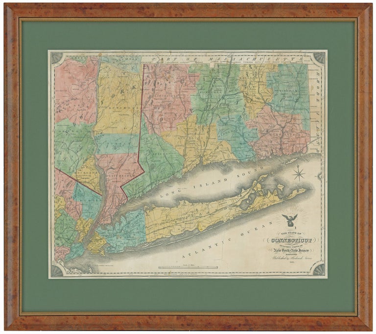
Connecticut. NEVERS, R./ DAMERUM, W. [Hartford, 1851] The State of Connecticut including Parts of New York and New Jersey. 23 x 28 ¼ inches (engraved area only. Original wash hand color, refreshed; re-mounted on new linen & expertly conserved; toned, some spotting, a few splits but overall very good. In a fine archival frame. Separately published, elegantly framed map of Connecticut. Nevers updated Damerum’s 1815 map Connecticut to such an extent as to constitute an entirely new map; yet remarkably, he utilized the very same copperplate as Damerum. In addition to adding the 24 towns (including Westport, Madison and Bridgeport) that had been incorporated since 1815, Nevers' map is significant for its inclusion of several railroad lines, which Thompson observes were delineated with “particular care.” Thompson further notes that the railroad information on the map was very up-to-date, including a recent spur from the New Haven and Springfield line and a “proposed” section of the Hartford, Providence and Fishkill line. Nevers’ edition also added town and county lines along with the populations of counties. Misspellings of towns on the Damerum edition were corrected by Nevers. This is the first of two states of the map, the second appearing in 1852. Thompson129; Rumsey 2562, second state (private collection).
Price: $3,750.00