
click here to zoom
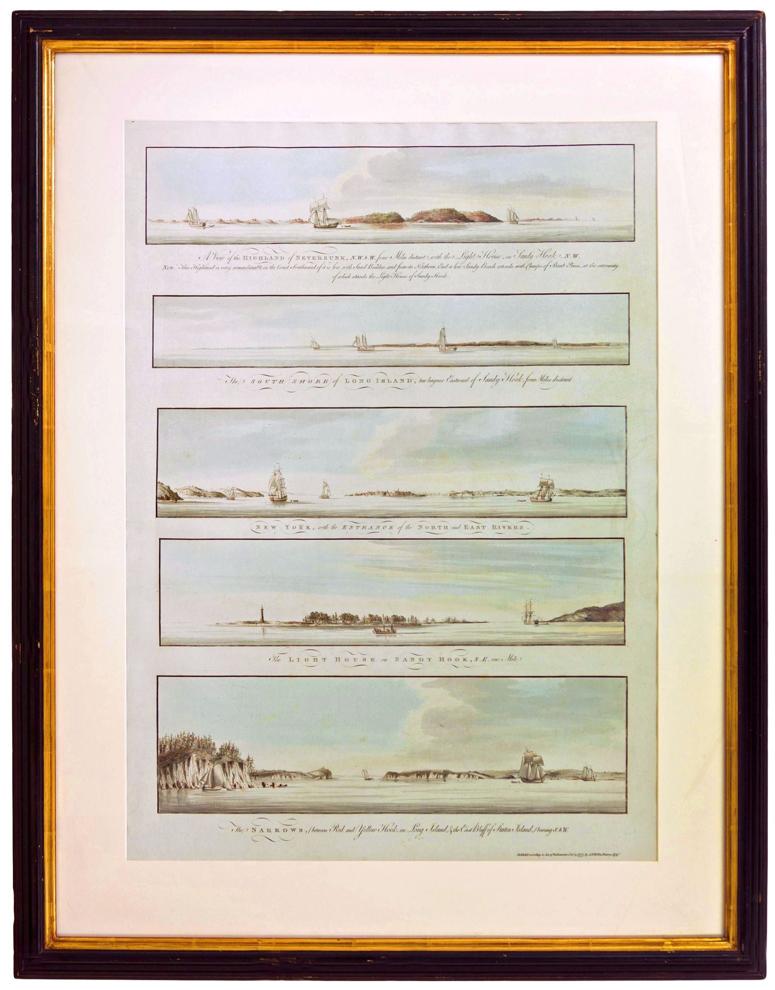
Five New York Harbor Views.
New York City/ American Revolution/ Navigation. DES BARRES, J. F. W. [London, Octr. 4, 1777] Five Profile Views from Various Points in New York Harbor, Including One Showing the City Itself. 28 x 18 ¼ inches. Aquatints with delicate, original wash color; fine condition. One of Des Barres's rarest works, much less often seen on the market than his chart of New York Harbor. A superb example of Des Barres's five profile recognition views that realistically portray what an 18th-century pilot would have seen at various points in sailing into New York Harbor and in approaching the city itself. While this work was very much a useful tool for the navigator, the delicacy of its execution elevates it to the level of fine art. We have not seen a finer example of this work; it was, in fact, reproduced in Manhattan in Maps. For these views Des Barres employed the then relatively new printing technology of aquatint. Aquatint produces gradient tones rather than lines and is especially effective at evoking light and shadow, which is certainly the case in this work. Aquatint prints thus often have the feel of watercolors. Only a handful of the views in Des Barres's Atlantic Neptune used aquatint, the rest being line engravings. The five views on this sheet are not arranged in proper sequence. The second from the top that displays the southern coast of Long Island should come first, followed the by the top view, which depicts the signal visual cue marking the entrance of the harbor's lower bay, the highlands of Navesink. Next should the view fourth from the top showing the lighthouse on Sandy Hook, the marker for the entrance to the lower bay. Next comes the bottom view that depicts the Narrows dividing the lower and upper bays; the cliffs on either side of the Narrows here show no signs of development. Finally, the view in the center shows the skyline of the city of New York in the distance, the openings of the Hudson and East rivers, and parts of Brooklyn and New Jersey on either side. The views were published about a year after New York fell to the British. Given the war was fully engaged when the views were produced, they have a strange quietude about them. This work, as mentioned, was published in Des Barres' magisterial atlas, The Atlantic Neptune, first appearing in 1775 and thereafter periodically until the end of the century. It was funded by the British government, itself an unusual circumstance in the production of maps in England to that date, for the use of the British Navy in America during the Revolution. Judging by the result, clearly no expense was spared in its creation; it has been described as “the most splendid collection of charts, plans, and views ever published.” (Rich, Bibliotheca Americana). Augustyn/ Cohen, Manhattan in Maps, pp. 66-69, illus. p. 68.
Sold