click here to zoom
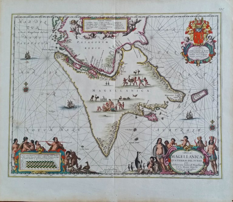
Patagonia/Tierra del Fuego. JANSSON, J. [Amsterdam: c. 1650] Tabula Magellanica Qua Tierrae del Fuego... 16 x 20 ¾ inches. Fine original color, fine condition. A stunning example, in full original color, of Dutch decorative cartography, this map abounds in images of indigenous peoples, flora, and fauna associated with the area. When it was first published, knowledge of the Strait of Le Maire and thus a water route to the Pacific below Tierra de Fuego was still relatively recent news. These discoveries were made in 1615-16 by the Dutch merchant-explorers, Jacques Le Maire and Jan Schouten. This fact suggests a reason why this and other Dutch maps of the southern tip of South America were so inordinately decorative—as a means of celebrating a signal Dutch achievement in oceanic exploration. Also, from Europeans’ earliest encounters with this area, many myths and legends became associated with it, such as that it was populated by giants. This and the region’s actual species that were in fact new and exotic to Europeans seemed to provide fodder to the visual imaginations of mapmakers. In the northeast portion of the island, a putative “Strait of Saint Sebastian” is shown; this fictitious feature appeared frequently on maps to the 18th century.
Sold