click here to zoom
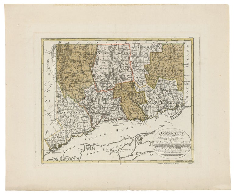
Connecticut. SOTZMANN, D. F. [Hamburg: 1796] Connecticut entworfen van D. F. Sotzmann… 14 x 17 1/8 inches. Full original wash color; fine condition with very wide margins. Separately published. One of the most advanced and detailed maps of Connecticut to date. Sotzmann's state maps are "among the rarest of cartographic Americana for the closing decade of the eighteenth century…Only a small number of American collections, among them the Library of Congress and Harvard University, have copies of all ten published maps" (Ristow). Modeled very closely on Blodget’s 1791 work, it includes “symbols for churches roads, court houses, distilleries, iron works, mills, academies, county lines, town lines and more” (Rumsey). Sotzmann’s map, however, improved the plotting of latitude and longitude in comparison with the Blodget. When compared to other state maps of the period, such as those in Carey's atlas, Sotzmann's seem to be the product of more modern era. Not only are they more detailed, but also their engraving is much more polished and precise. Strange to say, these maps produced in Germany represent some of the best cartography of American states produced in their day. Christoph D. Ebeling, the Hamburg scholar whose geographic studies provided the foundation for these maps, relied on his correspondence with American scholars to acquire the most up-to-date information. For example, the very rare Griffith wall map of Maryland, the first of the state produced in the state, is an important source for this map. Writing in a letter of another state map, Ebeling demonstrated his persistence in using the freshest information, "That of New York coasts (sic) me a great deal of trouble and many expenses to the Editor as the erection of new Counties obliged us to engrave a considerable part anew." This map was one of only 10 produced by the Ebeling and Sotzmann out of a proposed 18 for the Atlas von Nordamerika. Ebeling was one of the greatest 18th century European students of America, and he produced a massive, seven-volume work on the subject. Ebeling then engaged Daniel F. Sotzmann to compile and draft the maps for the above atlas to accompany Ebeling's work. Since the atlas was never completed, the maps were issued separately or in small groups at various dates beginning in 1794. It is because of this manner of publication that the maps are so rare. Thompson (1995 edition), no. 39; Ristow, W. American Maps and Mapmakers, pp. 169-177; Rumsey (on line) 2746.
Price: $5,000.00