click here to zoom
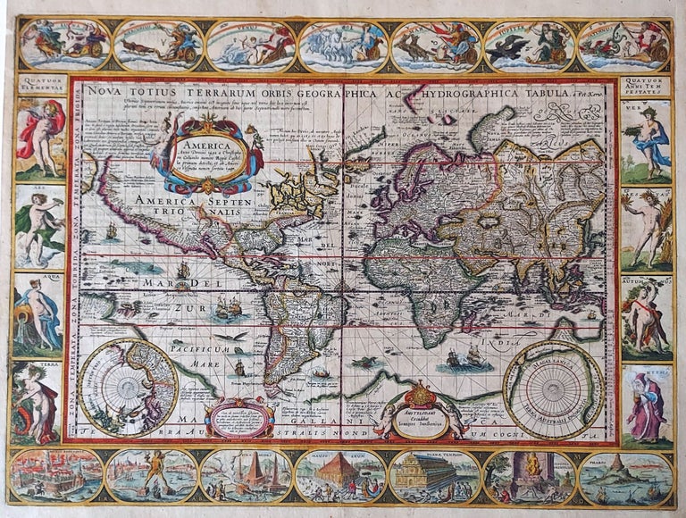
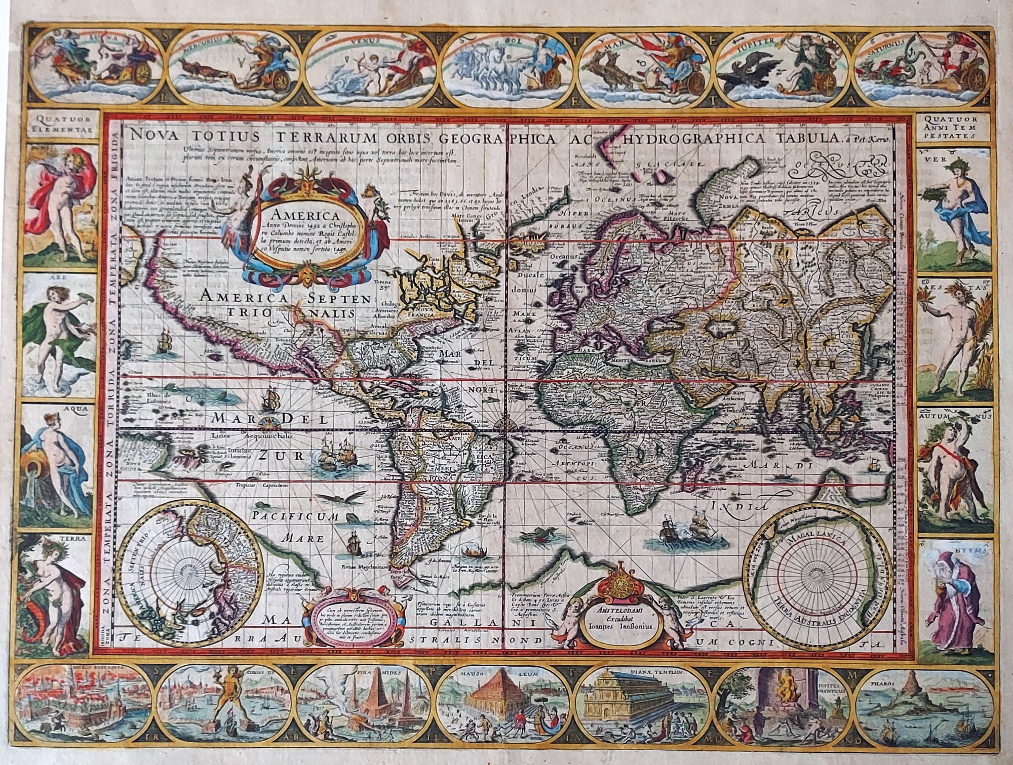
World/ Northwest Passage/ Australiana. KEERE, P. VAN DEN/ JANSSON, J. [Amsterdam, 1621/c. 1636] Totius Terrarum Orbis Geographica ac Hydrographica Tabula. 15 1/2 x 21 inches. Fine hand color; a few mended, inconspicuous into engraved surface & along a vertical crease, largely in margins, good overall. Van den Keere’s majestic world map in an attractive example. While Shirley praised Keere’s source, Blaeu’s Nova Totius Terrarum Orbis, as “one of the supreme examples of the mapmaker’s art,” he similarly lauded Keere’s work: “The clarity and precision of Keere’s engraving is in no way inferior to that of Josua van den Ende who engraved Blaeu’s map.” Keere’s map is more informative than Blaeu’s, particularly regarding the possible existence of a northern sea route to China. Using space left vacant on the Blaeu, Kaerius provided extensive Latin notations discussing the efforts to discover both the Northwest and a Northeast Passages. One proposes that the Strait of Anian and the Davis Strait are “perhaps one and the same.” Another explains “in the extreme north of America it is unknown whether there is water or land.” The Davis Strait is marked as a possible passage to China. To the east, several discoveries of the English explorer Hugh Willoughby are noted. Regarding the extreme northeast of Asia, Kaerius explains, “this is a very uncertain area of northern Asia…nevertheless we imitate others, and add nothing… until something certain comes out.” To the south, three entries describe supposed discoveries of the Spanish and Portuguese on the coast of the great Southern Continent, and one describes the fierce currents and violent seas of the Indian Ocean. The promontory named Beach is described as a “gold-bearing province.” Also labeled there are the kingdoms of Lucach and of Maletur, which are said to be teeming with spices. Keere engraved this map in 1608, shortly after the 1606 publication of Blaeu’s. Keere’s version preserves the rhumb lines that were present in the first state of the Blaeu but which were subsequently erased. At some point prior to 1621, Keere added the Strait of Le Maire. When Jansson acquired the plate in 1621, he added both his imprint and the date. The example of the map offered here is the fourth state of the map, with the Jansson imprint but with the 1621 date removed. Since Kaerius was unsuccessful in publishing an atlas, and Jansson only included the third state in two appendix editions, this fourth state of the map is virtually the only one that appears on the market. Pieter van den Keere (1571-1646?) was one of the most prolific of the Dutch cartographers at the beginning of the seventeenth century and an excellent engraver who often acted as his own publisher. He collaborated with Jodocus Hondius (his brother-in-law) and Jan Jansson (his nephew by marriage) on many publications. His maps of the world and America are rare. Van der Krogt 0001:1B2; Shirley 264 state 4. Imago Mundi XV:66-72.
Sold