click here to zoom
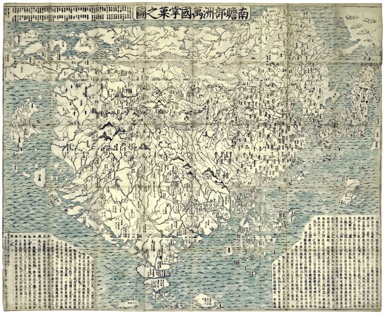
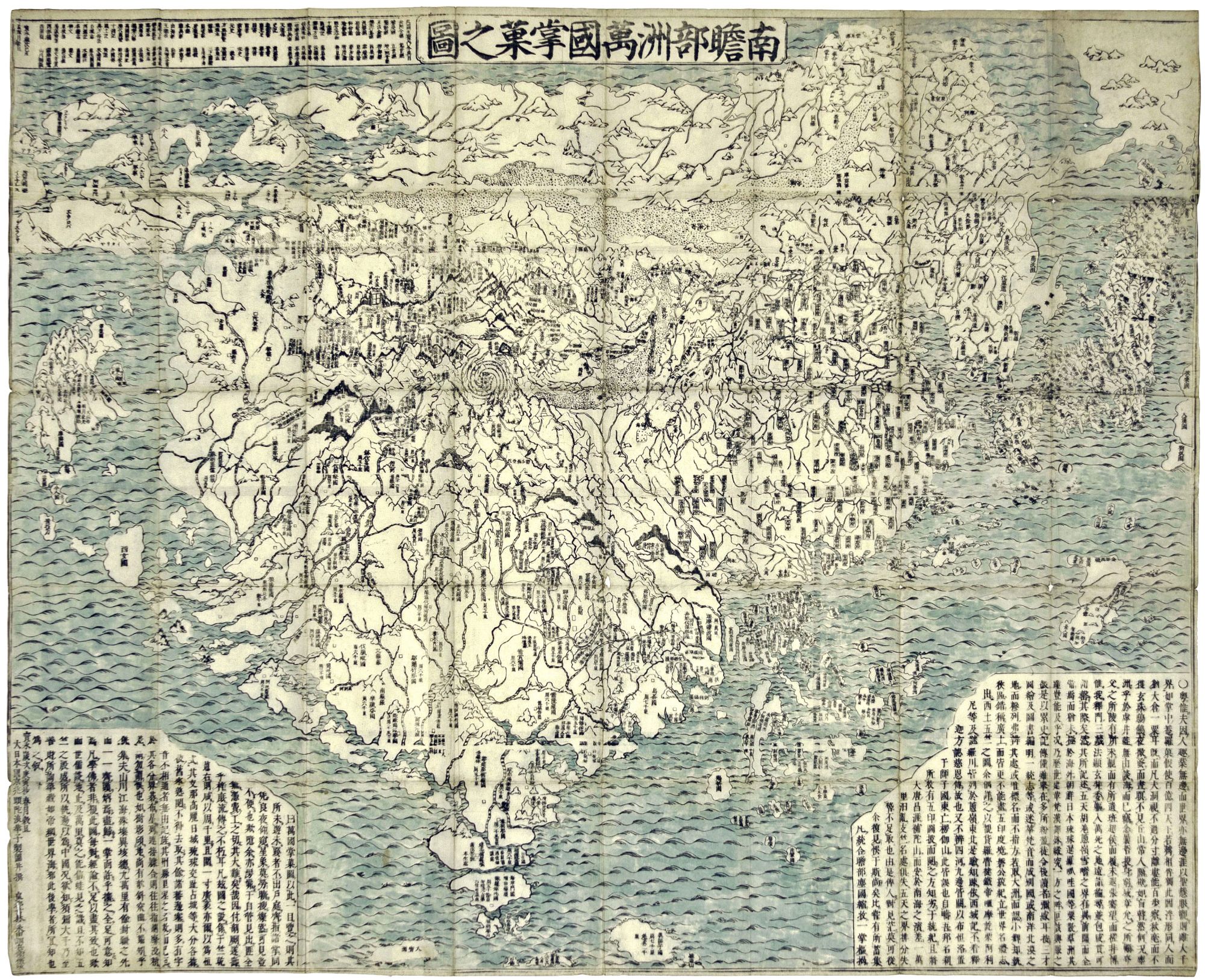
World Map/ Buddhism. Zuda RŌKASHI (Priest Hōtan) [Kyōto, c. 1710-1815] Nansen Bushu Bankoku Shōka No Zu. (“Outline Map of all the Countries of the Universe”) 45 x 57 ½ inches. Period wash color; nine woodblock sheets joined; folds reinforced, slight losses at some fold intersections, overall very good. This is the largest and most impressive, acquirable map we have seen that depicts the world according to Buddhist cosmology. Examples in full early color as here are very rare. China and India are positioned on the map at the center of the earth, and along with Japan, they occupy most of the map's surface. However, this was also ”the first Buddhist world map printed with European geographical knowledge” (History of Cartography), though the Americas, Europe, and Africa are minimally represented as islands. South America, for example, is the relatively small island below Japan. At top right, a land bridge joins Asia with another landmass, presumably North America. And the countries of Europe form an archipelago at upper left. Although the map is notable for its groundbreaking but primitive integration of Buddhist cosmology and Western geographic knowledge, its primary concern was Buddhist theology and history. Its author, Zuda Rokashi, was a scholar-priest who founded the Kegonji Temple in Kyoto. One of the map’s main purposes was to celebrate a most important event in Buddhist history—the pilgrimage of the famous Chinese Buddhist priest Hsuan-tsang (602-664 A.D.), who traveled to India to collect holy Sanskrit writings and visit the sacred places of Buddhism. The Japanese version of Hsuan-tsang’s Chinese narrative, the Si-yu-ki, was printed as late as 1653 and was the inspiration of this map. Hsuan-tsang not only brought to China and Japan a deeper understanding of Buddhism but also a richly detailed report of the country of its origin. His account of India, when finally translated in the West in the 19th century (accompanied by a reduced version of this map), formed the basis of historical and archeological studies of India between the classical Greek period and the 10th century period of Arabic travelers. Hence, this map has been long esteemed by European as well as Oriental scholars as a valuable source for the early place names of India and China. Without it, many of the original Asian place names of these countries would not have been preserved. The map’s text, which is in Chinese, concerns historic Buddhist sites and aspects of classical learning. (Place names of the European countries are given in both Chinese characters and Japanese kana-syllabary.) Other elements of Buddhist cosmology embodied in the map are that China, India, and Japan occupy two-thirds of the earth, and that the earth is square-shaped and centered on Mount Sumeru. Also, according to Buddhist belief, Lake Anavatapta, shown in the center of the northern part of India, is located south of a huge snowy mountain chain. The lake is the source of four rivers—the Ganges, Indus, Oxus, and the Sita (Tarim or Talihue in Sinkiang Province). Each river circles the lake once before moving off in its own direction. According to Prof. Unno (History of Cartography, footnote 301, p. 429), there were two editions of the map, both published in 1710 in Kyoto, by Bundaiken Uhei and by Nagata Chobee. We have closely examined illustrations of what are reported to be the two editions and found nothing to distinguish the two, and our example matches both illustrations in all discernible details. While it is believed that the map was published as late as 1815 (but always with the 1710 date), it is uncommon on the market. K. Unno in Harley/ Woodward, ed. History of Cartography, Vol. 2, Book 2, pp. 428-29, fig. 11.59; Cortazzi, Isles of Gold, p. 38 (no. 2), pl. 48 (p. 120); Beans, Japanese Maps of the Tokugawa Era, 1710.1, p. 20, illustrated facing p. 21.
Price: $12,000.00