
World/ Age of Discovery. SCHEDEL, Hartmann [Nuremberg: 1493] Secunda etas mundi. 14 ½ x 20 inches. Original woodcut; usual thread hole mends, else fine condition. .....
World/ Age of Discovery. SCHEDEL, Hartmann [Nuremberg: 1493] Secunda etas mundi. 14 ½ x 20 inches. Original woodcut; usual thread hole mends, else fine condition. .....
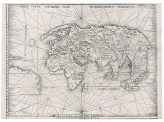
World. WALDSEEMULLER, M. [Strasbourg, 1513] Orbis Typus Universalis Iuxta Hydrographorum Traditionem. 17 3/8 x 22 1/2 inches. Woodcut with a strong printing impression; very slightly cropped along bottom, still overall excellent condition. .....
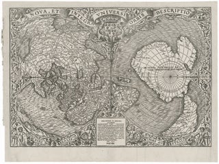
World. FINE, O. [Paris, 1531 [1532]] Nova, Et Integra Universi Orbis Descriptio . . . Orontius F. Delph . . . 1531 Mense Julio. 11 3/8 x 16 1/4 inches. Woodcut with a strong printing impression. Top & right side margins expertly extended with minor replacement of printed area at.....

World/ Jerusalem. BUNTING, H. [Magdeburg, 1581] Die ganze Welt in ein Kleeblatt…10 ¼ x 14 ¼ inches. Woodcut with fine hand color; side margins extended with very slight loss, reinforced fold separations at bottom, else excellent. .....
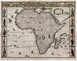
A vigorously decorative map of Africa--the first in English but adopting the rich Dutch cartes a figures style so popular at the time. As is customarily seen on 17th century maps, Africa's interior is filled with fictitious mountains, rivers and lakes as well as notations concerning legends, notably where gold.....
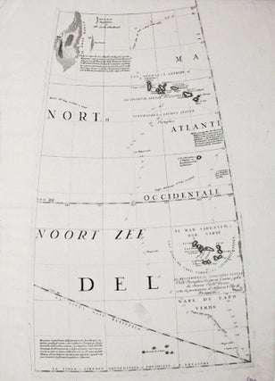
A gore (constituent globe part) by the greatest early globe maker, showing the Azores and Cape Verde island groups. Tracks of various 17th century European voyages headed to the East Indies, which used these islands as way stations, are plotted out, with their positions for particular dates indicated. In the.....
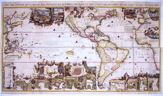
A splendid example, with rich, vibrant hand color, of a wall map of extraordinary intricacy and detail: "one of the most decorative maps of North America of the 18th century" (Tooley). Its elaborate illustrations provide a panorama of the Discovery Period, colorfully depicting the mores, rituals and practices of indigenous.....

[Reproduction of the 13th Century Ebstorf Medieval World Map c. 1234-1240] MILLER, Dr. Konrad [Stuttgart: 1898] Monialium Ebstorfensium Mappammundi quae exeunte saeculo XIII. videtur picta. Hannoverae nunc adservatur, edidit Conradus Miller. Jos. Roth’sche Verlagshandlung, Stuttgart. Chromolith Kunstandstalt v. Eckstein & Stahle, Stuttgart. Editio altera 1898. [Map of the world at the end.....
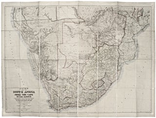
This large, superbly detailed map of South Africa shows the region just prior to the outbreak of the Second Boer War. The Boer territories - Orange Free State and the South African Republic - are both shown in yellow, as distinct from the surrounding red of British lands. The gold.....
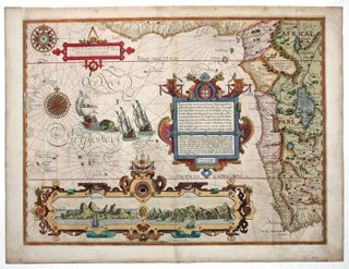
South & Western Africa. LINSCHOTEN, J. VAN/ LANGREN, A. & H. VAN [Amsterdam, 1596] Typus orarum maritimarum Guineae, Manicongo, & Angolae ultrap promontorium Bonae spei . . . 15 1/8 x 20 3/8 inches. Fine hand color; margins expertly extended with no loss of engraved surface, excellent. .....