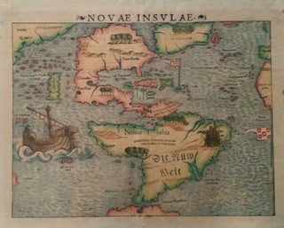
Americas/ Florida. WALDSEEMULLER, M./ FRIES, L. [Vienne-in-the-Dauphine, 1522/ 1541] Untitled Woodcut Map of the Americas. 11 ¼ x 14 7/8 inches. Excellent condition. Laurent Fries’s more elaborate edition of Waldseemuller's landmark "Tabula Terre Nove" (1513), the first separate, printed map of America. Although the Fries edition is geographically.....
Gulf Coast, Louisiana, Mississippi River
Out of stock
Occidentalis Americae partis, ve, earum Regionum quas Christophorus Columbus.
Arguably the most beautifully engraved early map of the Caribbean, including Florida and the Southeast, here with color of uncommon beauty. The map includes representations of Columbus’ ships and various notes regarding his discoveries. It appeared in Book IV of De Bry’s Grands Voyages with text by Benzoni. De Bry’s.....
Southeast/ Florida/ Columbia/ Bolivia ORTELIUS, A./ CHIAVES, H. [Antwerp/ London, 1584/ 1606] La Florida. Auctore Hieron. Chiasues. Peruviae Auriferae Regionis Typus… Guastecan Reg. 14 x 18 inches. Fine original color; light staining along centerfold & a bit in the margins, else excellent condition. .....
South America/ Brazil/ Caribbean/ Florida. DE BRY, T. [Frankfurt, 1592/ 1624] Americae Pars Magis Cognita. Chorographia nobilis & opulentae Peruanae Provinciae, atque Brasiliae, . . . MDCXXIV. 14 3/8 x 17 1/4 inches. Fine hand color; margins expertly extended with no loss of engraved surface, else excellent condition. .....
Haemisphaerium stellatum Australe aequali sphaerum proportione.
In this arresting work, constellations of the southern skies, as if viewed from deep in space, can be seen superimposed over a portion of the earth. The area depicted “beneath” the stars extends from the United States to the South Pole and includes all of South America. Because this chart.....
United States/Early Geographic Education/ Native American History. DAWES Jr., Samuel [Mississippi?: Dated: 1820] A Map of the United. States By Samuel Dawes Jr. 1820. [Verso:] Asia. 18 ¾ x 23 3/8 inches. Pen & ink & watercolor on woven paper. Some staining and age toning, three neatly closed splits into.....
United States/ Cartographic Curiosity. BOYNTON, George W. (engraver)/ TUTTLE, Joseph Willard (publisher) [Boston: Tremont Print Company: dated 1841] A MAP OF THE UNITED STATES, FROM THE LATEST SURVEYS. WITH THE HEIGHT OF MOUNTAINS And length of the PRINCIPAL RIVERS. PATENT. 25 3/4 x 25 inches (image not including margins). Lithographed map.....


