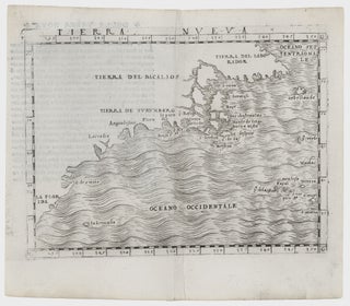
Northeast-Southeast/ New York City/ Bermuda. GASTALDI, G. [Venice, 1548] Tierra Nueva. 5 1/4 x 6 3/4 inches. A fine example with an uncommonly strong impression. .....
Northeast-Southeast/ New York City/ Bermuda. GASTALDI, G. [Venice, 1548] Tierra Nueva. 5 1/4 x 6 3/4 inches. A fine example with an uncommonly strong impression. .....
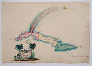
Cuba/ Opera History. CARDENA, Mariano/ BECHERINIE, F. [Havana, 1848] Arribo de Albina Steffanoni a la Isla de CUBA. 1848. 8 x 11 inches (sheet size). Manuscript in pen & ink & watercolors on heavy, watermarked wove paper, bit of soiling & toning, else excellent. [With:] A ms. sonnet titled Omaggio.....
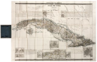
Cuba/ Havana. COELLO, D. F. [Madrid, 1851 & 1855] Isla De Cuba (both sheets with same title) Each, 30 x 41 1/2 inches. Pair of folding maps on heavy paper, with original outline color, in original covers; some discoloration at a few folds, very slight wear at fold intersections.....
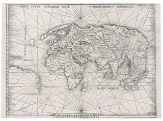
World. WALDSEEMULLER, M. [Strasbourg, 1513] Orbis Typus Universalis Iuxta Hydrographorum Traditionem. 17 3/8 x 22 1/2 inches. Woodcut with a strong printing impression; very slightly cropped along bottom, still overall excellent condition. .....
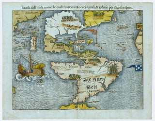
Excellent example of the earliest separate map of the entire Western Hemisphere. This was also the earliest map to refer to the Pacific Ocean (along with Munster's world map) by a variant of its present name, Mare pacificum. It was one of earliest acquirable maps to show Japan prominently, which.....
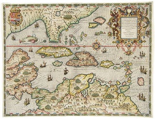
Arguably the most beautifully engraved early map of the Caribbean, including Florida and the Southeast, here with color of uncommon beauty. The map includes representations of Columbus’ ships and various notes regarding his discoveries. It appeared in Book IV of De Bry’s Grands Voyages with text by Benzoni. De Bry’s.....
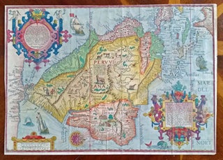
South America/ Southeast U.S./ Gulf of Mexico. LINSCHOTEN, J. VAN [Amsterdam, 1596/ ?] Delineatio omnium orarum totius Australis partis Americae, . . . 15 x 20 1/4 inches. Fine, possibly early hand color; right margin with some expert reinstatement of engraved border, very good. .....

Bermuda. BLAEU, W./ NORWOOD, R. [Amsterdam, 1642] Mappa Aestivarum Insularum, alias Barmudas . . . 15 7/8 x 21 inches. Superb original color; a few light marginal stains, mend in lower right corner, well away from printed image, else excellent. The most richly decorative, early.....
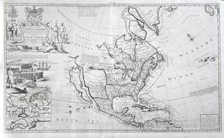
North America/ California as Island. MOLL, H. [London, 1720] To the Right Honourable John Lord Sommers . . . This Map of North America . . . 22 5/8 x 38 inches. Original outline color; few, small wormholes in upper margin, reinforcement in lower margin, else excellent condition. .....
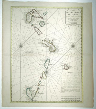
A very handsome example of De l’Isle’s map of the French Antilles, covering an area stretching from Guadeloupe in the north to Grenada in the south. Included on it are St. Vincent and the Grenadines, showing and naming both Bequia and Mustique. This is the Amsterdam edition of the map.....
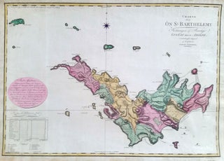
FAHLBERG, Samuel [Stockholm: 1801] Charta ofver On St. Barthelemy – Konungen af Sverige Gustaf den IV. Adolph . . . 20 X 28 inches. Fine hand color; a few mended, marginal splits, else excellent. .....
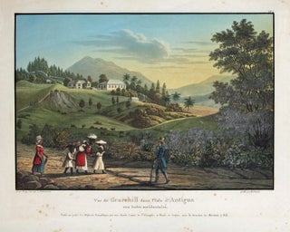
Antigua/ Slave Emancipation. STOBWASSER, L./ HURLIMANN [Basel, 1835] Vue de Gracehill dans I’Isle d’Antigoa aux Indes occidentales. 8 ¾ x 11 1/8 inches. Aquatint with fine original color; slight mended edge split, few spots, else excellent. Rare, luminously colored view that relates directly to the then recent emancipation of slaves.....
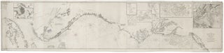
Nautical Chart: Block Island to Cuba. BLUNT, E. & G. W./ COPLEY, Charles [New York, 1853] Coast Of North America from Point Judith to Cape St. Antonio. (Island Of Cuba) Including The Bhama Banks… Every Authentic Survey, American, English & Spanish, Has Been Used In The Construction Of This Chart… 29.....
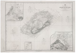
Bermuda. U. S. NAVY HYDROGRAPHIC OFFICE [Washington, DC: March 1878/ June 1887] North Atlantic Ocean. Bermuda Islands. From The Most Recent Brit. Admty. Surveys. 1877. 28 x 38 ¼ inches. Lithograph with three insets printed on separate sheets & pasted on. Lighthouses denoted with hand color. Expertly mounted on new.....
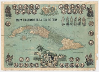
Cuba/ Cuban Revolution. MAUCCI, M. [Barcelona: Maucci, 1896.] Mapa Ilustrado De La Isla De Cuba. Color lithograph. 29 ½ x 41 inches (75 x 104 cm) Mounted on linen as issued; chipping along edges, some splits at folds, light water staining in upper border, still overall good to very good. .....
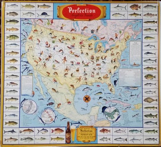
HORLACHER BREWING CO. [Allentown, Pennsylvania, 1946] Perfection Angler's Guide. 32 x 34 ½ inches. Color-printed. Excellent condition with vibrant color. A scarce, vibrant and informative promotional poster featuring two of mankind’s greatest pleasures—beer and.....

FAHLBERG, Samuel [Stockhom: 1801] Charta ofver On St. Barthelemy – Konungen af Sverige Gustaf den IV. Adolph . . . 20 X 28 inches. Fine hand color; a few mended, marginal splits, else excellent. .....