
Northeast/ New Jersey. HOMANN, J. B. [Nuremberg, 1724] Nova Anglia Septentrionali Americae implantata . . . 19 ¼ x 22 ¾ inches. Fine original body color, cartouche with later color, slight fading of color along centerfold, else excellent. .....
Northeast/ New Jersey. HOMANN, J. B. [Nuremberg, 1724] Nova Anglia Septentrionali Americae implantata . . . 19 ¼ x 22 ¾ inches. Fine original body color, cartouche with later color, slight fading of color along centerfold, else excellent. .....
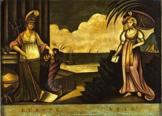
Geographic Allegorical Figures. W.B. WALKER (publisher) [London: 4 Fox & Knot Court, Cow Lane: 1805] EUROPE. ASIA. 10 ½ x 14 3/8 inches. Mezzotint, transferred to glass, finished with oil color. Slightly age-toned, small area of lower right corner chipped off, two areas of bubbling; color rich & vibrant, overall.....
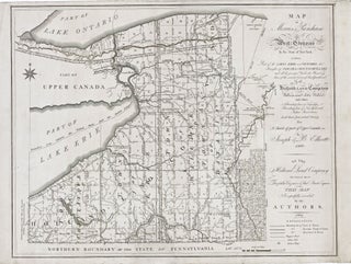
New York State/ Land Speculation. ELLICOTT, J. & B. [Philadelphia: 1801/ 1804] Map of Morris's Purchase or West Geneseo in the State of New York: Exhibiting Part of the Lakes Erie and Ontario, the Straights of Niagara, Chautauque Lake and All the Principal Waters ... Purchased by the Holland Land.....
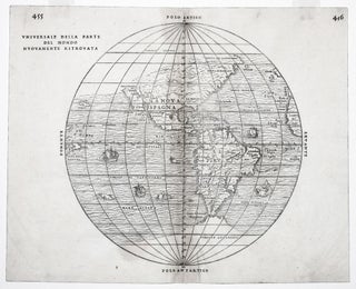
The rare first state of an important and in some ways groundbreaking map. The woodblock for this map was destroyed shortly after its publication in a fire in November of 1557, hence its rarity. The map was compiled by the great Venetian cartographer, Giacomo Gastaldi, and appeared in a three-volume.....
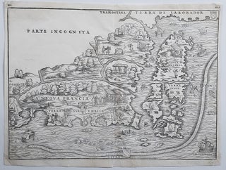
New England/ New York City. RAMUSIO, J. B./ GASTALDI, G. [Venice, 1556] La Nuova Francia. 10 1/2 x 14 1/2 inches. Woodcut map. A few minor marginal repairs, else excellent condition. .....
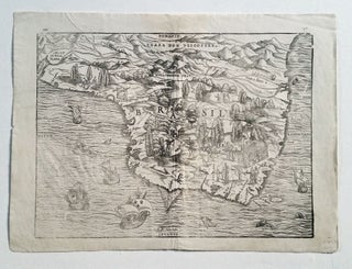
Brazil. GASTALDI, G./ RAMUSIO, J.B. [Venice, 1556/ 1606] Brasil. 10 ¾ x 14 ½ inches. Woodcut in very good condition with wide margins. One of the first separate maps of Brazil and certainly among the most richly illustrated. Indigenous peoples are depicted at various labors and activities, with an emphasis.....
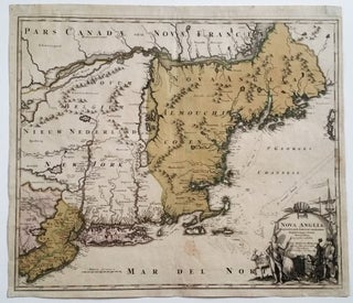
Northeast/ New Jersey. HOMANN, J. B. [Nuremberg, 1724] Nova Anglia Septentrionali Americae implantata . . . 19 ¼ x 22 ¾ inches. Fine original wash color; lightly age-toned, a few light stains, overall very good with a strong impression. .....
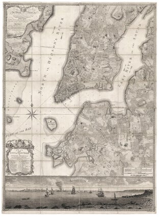
Rare; a superb example of the best executed and most beautiful, printed map one can acquire of early New York, and arguably, the masterpiece of 18th century, American, urban cartography. In addition to a plan of the city itself, the work provides a remarkable evocation of the pre-development landscape of.....
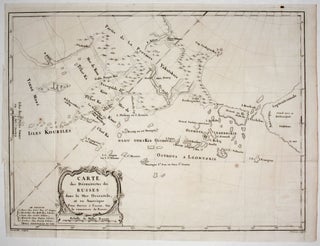
A scarce, attractively engraved map, from Russian sources, focusing on northeastern Russia, the Bering Strait and its islands, and Alaska. It appeared in M. Marbault’s Essai sur le commerce de Russie…, which is an account of Russian trade as well as a history of Russian explorations in the areas depicted.....
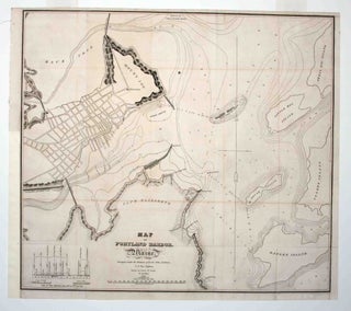
Early, detailed plan of Portland Harbor, produced to accompany a report to the 23rd Congress with regard to a proposed breakwater for the harbor. The survey was executed by Lt. Col. John Anderson at the instruction of the Secretary of War Lewis Cass; the chart itself was drawn by Lt.....

New York City/ Printing History/ Post Prohibition. VOORHIES, Stephen Jerome & STONE, Harold F. (artists) / FRANK B. DOLPH PUBLISHER. [New York: 1938] Midnight Map of Manhattan. 22 ½ x 17 ½ inches. Photostat (negative image) on matte photographic paper. Creasing lower left corner, a few marginal split, else excellent. .....
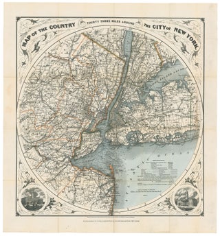
New York City/ New Jersey. G. W & C. B. COLTON & CO. [New York, 1889/ 1895] Map of the Country Thirty Three Miles Around The City of New York. 22 ¼ x 21 inches. Original wash & outline color; ex folding map with original cover, separate, map here flattened.....